
[ Archive ]

|
ASPB and CIMSS Weekly Report
[ Archive ] |
|
IN THE PRESS:
ITEMS FOR THE ADMINISTRATOR:
ITEMS FOR THE ASSISTANT ADMINISTRATOR:
ITEMS FOR THE OFFICE DIRECTOR, STAR:
Tri-Agency Atlantic Hurricane Research Field Program Dry Run: Beginning
August 15th, NOAA, NASA and NSF scientists will collaborate on a major
research field project in the Atlantic Ocean basin to study tropical
cyclone genesis and intensity change. Along with the routine operational
reconnaissance aircraft provided by NOAA and the USAF, three additional
piloted aircraft and the unmanned Global Hawk will participate. Key to
the forecast and mission support will be satellite data and products
provided by GOES and other polar orbiters. Chris Velden from CIMSS is
coordinating this effort with NESDIS and its NASA partners. A 'dry run'
of the field exercise is being conducted at present, with Velden
participating at one of the mock operations centers at NCAR in Boulder,
Colorado. The experiment will run through the end of September. (C.
Velden, CIMSS, 608-262-9168)
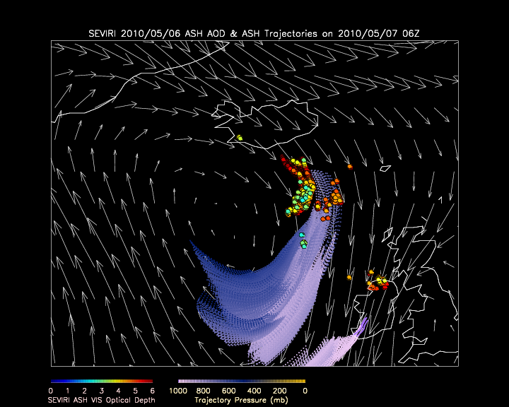
Developmental SEVIRI based Volcanic Ash Trajectory Predictions: As
part of activities under the NOAA Volcanic Ash Working Group (VAWG)
Science Team, Advanced Satellite Products Branch (ASPB) scientists used
aerosol trajectory forecast capabilities from the International version
of Infusing Satellite data into Environmental Applications (IDEA-I) to
demonstrate how Spinning Enhanced Visible and Infrared Imager (SEVIRI)
volcanic ash visible optical depth and ash top pressure retrievals could
be used to initialize volcanic ash trajectory predictions associated
with the April 2010 Eyjafjoll eruption in southern Iceland. IDEA-I
trajectory initialization software was adapted for SEVIRI ash retrievals
and delivered to scientists at the NOAA Air Resources Laboratory (ARL)
for use in Operational HYbrid Single-Particle Lagrangian Integrated
Trajectory (HYSPLIT) volcanic ash predictions. (R.B. Pierce, E/RA2,
608-890-1892, brad.pierce@noaa.gov, M. Pavolonis, E/RA2, 608-263-9597,
mpav@ssec.wisc.edu, J. Sieglaff, CIMSS, 608-265-5357,
justins@ssec.wisc.edu )
 (Click image to enlarge)
Figure caption: 24hr Volcanic Ash trajectory prediction associated with the Eyjafjoll eruption in southern Iceland from IDEA-I (http://idea-i.ssec.wisc.edu/)
valid at 06Z May 07, 2010. The IDEA-I trajectories are colored by their
pressure (mb) and were initialized using SEVIRI ash visible optical
depth (colored circles) and ash top pressure retrievals provided by Mike
Pavolonis (NESDIS/STAR). 500mb wind predictions from the NWS Global
Forecasting System (GFS) are shown in white. An animated version of this
image is available at ftp://ftp.ssec.wisc.edu/pub/raqms/VAST/ash_traj_fx.gif.
ITEMS FOR THE DIVISION CHIEF, CoRP:
Teacher Workshop: Steve Ackerman & Margaret Mooney of CIMSS participated in the Earth Systems Information Partners (ESIP) Fall meeting in Knoxville, TN. They organized a teacher workshop on their project Climate Literacy Ambassadors. The session featured activities and resources from an on-line course on Global and Regional Climate Change (http://cimss.ssec.wisc.edu/climatechange/) created to clarify concepts and graphs from the 2007 Intergovernmental Panel on Climate Change (IPCC) Summary for Policy Makers. After a short presentation, participants worked through two activities including a statistics exercise utilizing ice-on/ice off data from Madison, Wisconsin. G6-12 science teachers were then invited to join a Global Climate Change Educator project called Climate Literacy Ambassadors where they can take the on-line course in October and receive stipends and become ambassadors of climate literacy in their local schools and communities. The workshop was organized with support from NESDIS Education Office, Nina Jackson. (Margaret Mooney, CIMSS; S. Ackerman, CIMSS, 608-263-3647; Nina Jackson, NESDIS)CIMSS Celebrates Four Years of Supplying MODIS Products in AWIPS to NWS Users: July 2010 marks the 4-year anniversary of the point that the Cooperative Institute for Meteorological Satellite Studies (CIMSS) first began to supply Moderate Resolution Imaging Spectroradiometer (MODIS) images and products to National Weather Service (NWS) users in an Advanced Weather Interactive Processing System (AWIPS) format. To date, 51 NWS forecast offices have begun to use the CIMSS-supplied MODIS imagery in their local AWIPS workstations, with 22 of these offices actively mentioning MODIS in their daily Area Forecast Discussions. Examples of the MODIS images being supplied in an AWIPS format can be found on the CIMSS Satellite Blog (http://cimss.ssec.wisc.edu/goes/blog/archives/6199). (J. Gerth, CIMSS, 608- 263-4942, S. Bachmeier, CIMSS, 608-263-3958)
GOES-R land surface emissivity ATBD submitted: GOES-R land surface emissivity ATBD Submitted: The Geostationary Operational Environmental Satellite (GOES)-R land surface emissivity (LSE) Algorithm Theoretical Basis Document (ATBD) for the Advanced Baseline Imager (ABI) was submitted to the GOES-R Algorithm Integration Team (AIT). This ATBD covers the theory of using GOES-R high temporal information for retrieving LSE from ABI measurements. (Jun Li, CIMSS, 608-262-3755, Jun.Li@ssec.wisc.edu; Zhenglong Li, CIMSS, 608-890-1982; Xin Jin, CIMSS, 608-890-0619; Tim Schmit, tim.j.schmit@noaa.gov, 608-263-0291)
VISITORS:
NEXT WEEK:
LOOKING AHEAD:
| Archived Weeklies Page | Submit a report item |