 |
ASPB and CIMSS Weekly Report
[ Archive ] |
 |
ASPB AND CIMSS WEEKLY HIGHLIGHTS FOR THE WEEK ENDING AUGUST 21, 2010
IN THE PRESS:
CIMSS Featured onYouTube: Steve Ackerman and
the Cooperative Institute for Meteorological Satellites Studies (CIMSS)
are featured in a video that is part of Wisconsin Research Profiles, a series produced by the University of Wisconsin-Madison communications office. The video is available through YouTube at http://www.youtube.com/uwmadisoncio (see link for Steve Ackerman). The 6-minute video discusses CIMSS' research, history and collaborations with NOAA.
(S. Ackerman, CIMSS, 608-263-3647)
Press Release on CIMSS Re-competition: The
University of Wisconsin-Madison issued a press release on the recent
Cooperative Institute for Meteorological Satellite Studies (CIMSS)
re-competition. The press release is at http://www.news.wisc.edu/18311.
(J. Key, E/RA2, 608-263-2605, jkey@ssec.wisc.edu)
ITEMS FOR THE ADMINISTRATOR:
ITEMS FOR THE ASSISTANT ADMINISTRATOR:
ITEMS FOR THE OFFICE DIRECTOR, STAR:
ITEMS FOR THE DIVISION CHIEF, CoRP:
GOES-R ABI Visibility CDR: R. Bradley Pierce led the Algorithm Theoretical Basis discussion for the Geostationary Operational Environmental Satellite (GOES)-R Advanced Baseline Imager (ABI) Visibility retrieval at the final GOES-R Algorithm Working Group (AWG) Aviation Team Critical Design Review (CDR) on August 20, 2010. W. Straka participated via a telecon. Visibility is the tier 2 product for GOES-R that is being developed at the Cooperative Institute for Meteorological Satellite Studies (CIMSS) by Brad Pierce and Allen Lenzen. (R.B. Pierce, E/RA2, 608-890-1892, brad.pierce@noaa.gov)
GOES-R ABI Waiver Simulation and Product Analysis: Conditions matching an out-of-specifications waiver request for the 13.3 micron band on the Geostationary Operational Environmental Satellite (GOES)-R Advanced Baseline Imager (ABI) were simulated by the Cooperative Institute for Meteorological Satellite Studies (CIMSS) GOES-R Analysis Facility for Instrument Impacts on Requirements (GRAFIIR) team. GOES-R Algorithm Working Group (AWG) proxy data were altered in order to simulate the waiver and the GRAFIIR team provided analysis to the GOES-R Program Office as a decision-making aid. The simulated waiver data were compared to the baseline proxy data for 12 products. The analysis was presented to the Integrated Modeling Working Group (IMWG) and the "Tiger Team" assembled to address the waiver on 20 August 2010. (M. Gunshor, CIMSS, 608-263-1146)
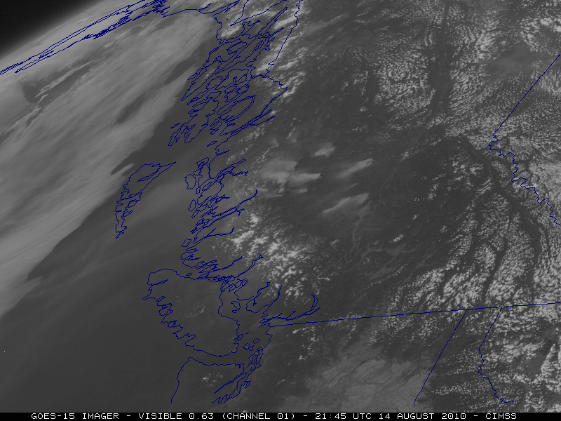
CIMSS VISIT Activities and CIMSS Satellite Blog Updates: The Virtual Institute for Satellite Integration Training (VISIT) distance learning module "The University of Wisconsin Convective Initiation Product" (http://rammb.cira.colostate.edu/visit/uwci.html) was led by S. Lindstrom on August 17, 2010. The National Weather Service forecast office at Blacksburg, Virginia participated in the VISIT lesson. Updates to the Cooperative Institute for Meteorological Satellite Studies (CIMSS) Satellite Blog in support of the beginning of the Geostationary Operational Environmental Satellite (GOES-15) Science Test included GOES, Polar Operational Environmental Satellite (POES), and Moderate Resolution Imaging Spectroradiometer (MODIS) images of severe thunderstorms that produced damaging winds in Arizona (http://cimss.ssec.wisc.edu/goes/blog/archives/6380), wildfires in British Columbia, Canada (http://cimss.ssec.wisc.edu/goes/blog/archives/6366), and an isolated weak tornado event in Minnesota (http://cimss.ssec.wisc.edu/goes/blog/archives/6346). (S. Lindstrom, CIMSS, 608-263-4425, S. Bachmeier, CIMSS, 608-263-3958)
 (Click image to enlarge)
Figure caption: An animation of GOES-15 visible images showing the spread of smoke from intense wildfires in British Columbia, Canada on August 14, 2010.
VISITORS:
NEXT WEEK:
LOOKING AHEAD: