 |
ASPB and CIMSS Weekly Report
[ Archive ] |
 |
ASPB AND CIMSS WEEKLY HIGHLIGHTS FOR THE WEEK ENDING OCTOBER 9, 2010
IN THE PRESS:
ITEMS FOR THE ADMINISTRATOR:
ITEMS FOR THE ASSISTANT ADMINISTRATOR:
ITEMS FOR THE OFFICE DIRECTOR, STAR:
ITEMS FOR THE DIVISION CHIEF, CoRP:
VIIRS Land Team Validation Workshop: The NPOESS Preparatory Project (NPP) Visible Infrared Imager/Radiometer Suite (VIIRS) Land Product Validation Team held a validation workshop in College Park, MD, October 5-6, 2010. J. Key participated remotely and gave a presentation on the cryosphere team's VIIRS validation activities. (J. Key, E/RA2, 608-263-2605, jkey@ssec.wisc.edu)
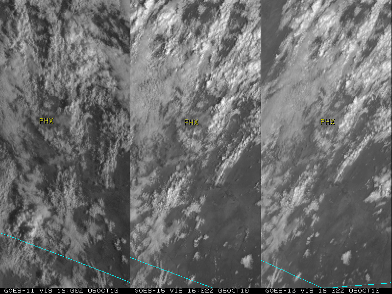
CIMSS VISIT Activities and CIMSS Satellite Blog Updates: The Virtual Institute for Satellite Integration Training (VISIT) distance learning modules "The University of Wisconsin (UW) Nearcasting Product" (http://rammb.cira.colostate.edu/visit/uwnc.html) and "The UW Convective Initiation Product" (http://rammb.cira.colostate.edu/visit/uwci.html) were led by S. Lindstrom on October 4 and 7, 2010. Staff from the National Weather Service forecast offices at Riverton, Wyoming and Des Moines, Iowa participated in the VISIT lessons. In addition, a number of posts were added to the Cooperative Institute for Meteorological Satellite Studies (CIMSS) Satellite Blog, including Geostationary Operational Environmental Satellite (GOES), Moderate Resolution Imaging Spectroradiometer (MODIS), and Advanced Very High Resolution Radiometer (AVHRR) images of thunderstorms that produced historically large hail in southern Arizona on October 5, 2010 (http://cimss.ssec.wisc.edu/goes/blog/archives/6955). (S. Lindstrom, CIMSS, 608-263-4425, S. Bachmeier, CIMSS, 608-263-3958)
 (Click image to enlarge)
Figure caption: GOES-11 (left panel), GOES-15 (center panel), and GOES-13 (right panel) visible images showing multiple clusters of severe thunderstorms moving across southern Arizona on October 5, 2010.
VISITORS:
NEXT WEEK:
LOOKING AHEAD: