
[ Archive ]

|
ASPB and CIMSS Weekly Report
[ Archive ] |
|
IN THE PRESS:
ITEMS FOR THE ADMINISTRATOR:
ITEMS FOR THE ASSISTANT ADMINISTRATOR:
ITEMS FOR THE OFFICE DIRECTOR, STAR:
CIMSS Satellite Product Workshop in Salt Lake City: On 16-17 February 2011, Cooperative Institute for Meteorological Satellite Studies (CIMSS) and STAR scientists conducted a workshop in Salt Lake City, UT with staff from the National Weather Service (NWS) Western Region (WR) Headquarters, the NWS Salt Lake City Weather Service Forecast Office (WSFO), and the NWS Center Weather Service Unit (CWSU) at the Salt Lake City Federal Aviation Administration (FAA) Air Route Traffic Control Center (ARTCC). W. Feltz, K. Strabala, and J. Gerth (CIMSS) along with G. S. Wade (STAR/ASPB) presented information on CIMSS products, some of which are already available (via the NWS Advanced Weather Interactive Weather Processing System (AWIPS)) with others to be implemented or in development. These products serve to prepare NWS forecasters for day-1 use of future GOES (Geostationary Operational Environmental Satellite)-R data. One day of the workshop utilized remote access, via webinar, to include staff from other NWS WR WSFOs as well as other CIMSS and ASPB presenters in Madison, WI (T. Schmit, R. Aune, S. Bachmeier, and S. Lindstrom). A variety of current GOES data (Imager and Sounder), NASA MODIS (MODerate resolution Imaging Spectroradiometer) imagery, and simulated imagery were demonstrated as proxy GOES-R data to be used for forecasting, nearcasting, and aviation applications. Areas of observational data needs noted by NWS staff were also part of the process, with the intent to gauge where applications from satellite data might be effective. (W. Feltz, CIMSS, 608-265-6283, wayne.feltz@ssec.wisc.edu; G.S. Wade, E/RA2, 608-263-4743, gary.s.wade@noaa.gov)
Satellite-based Convective Initation Article Published: A paper titled "Nowcasting Convective Storm Initiation
Using Satellite-Based Box-Averaged Cloud-Top Cooling and Cloud-Type
Trends", authored by
Justin M. Sieglaff, Lee M. Cronce, Wayne F. Feltz, Kristopher M. Bedka,
Michael J. Pavolonis, and Andrew K. Heidinger, was published in the
January 2011 Journal of Applied Meteorology and Climatology. This paper
describes using Geostationary Operational Environmental Satellite (GOES) imager cloud typing methodology and cloud top
cooling rates using the 10.7 micron infrared channel to determine which
maturing cumulus clouds were likely to grow into significant convection.
The technique was shown to
have a probability of detection of 55% and a false alarm rate of 25%.
More information and real-time quicklooks from University of Wisconsin
convective initiation methodology can be found at
http://cimss.ssec.wisc.edu/snaap/convinit/quicklooks/ and
http://cimss.ssec.wisc.edu/goes_r/proving-ground/SPC/SPC.html. (W. Feltz,
CIMSS, 608-265-6283, J. Sieglaff, CIMSS, Lee Cronce, CIMSS)
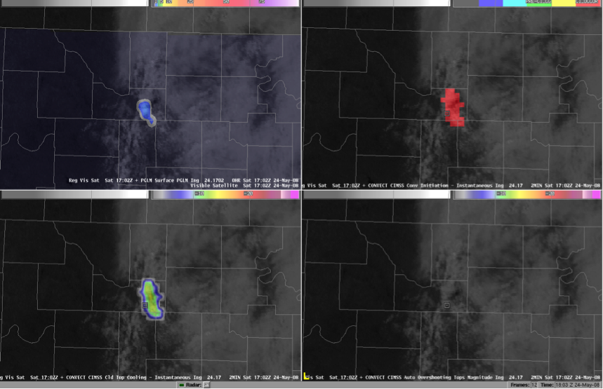 (Click image to enlarge)
Figure caption: 4-panel display within AWIPS of Lightning Mapping Array
(LMA) 8-km Psuedo-Geostationary Lightning Mapper (top left), GOES imager
UWCI convective initiation (top right), GOES imager UWCI cloud-top
cooling rate (bottom left), and GOES imager overshooting-top magnitude
(bottom right) for the 24 May 2008 archive case event.
GOES Sounder Nearcasting implemented for NWS Western Region: The nearcasting model, developed at the Cooperative Institute for Meteorological Satellite Studies (CIMSS), is now generating hourly nearcasts of atmospheric instability for the National Weather Service Western Region in real-time. The model uses temperature and moisture profiles measured by the GOES-11 Sounder to produce 9-hour nearcasts of atmospheric de-stabilization. The nearcasts are useful for locating areas where severe thunderstorms are most likely to occur. Nearcast products can be viewed on line at http://cimss.ssec.wisc.edu/model/nrcw/. (R. Aune, E/RA2, 608-262-1071, robert.aune@noaa.gov)
ITEMS FOR THE DIVISION CHIEF, CoRP:
CIMSS VISIT Activities: The Virtual Institute for Satellite Integration Training (VISIT) distance learning modules "The University of Wisconsin Convective Initiation Product" (http://rammb.cira.colostate.edu/training/visit/training_sessions/the_uw_convective_initiation_product/) and "Morphed Total Precipitalble Water Detection" (Morphed Intergrated Microwave Imagery at the Cooperative Institute for Meteorological Satellite Studies, MIMIC) (http://rammb.cira.colostate.edu/training/visit/training_sessions/morphed_tpw_detection/) were led by S. Lindstrom on February 16 and 17, 2011. Staff from the Center Weather Service Unit (CWSU) at Cleveland, Ohio and the National Weather Service forecast office at La Crosse, Wisconsin participated in the VISIT lessons. (S. Lindstrom, CIMSS, 608-263-4425)
NASA Panel Review: Andrew Heidinger served on a NASA Panel Review in Potomac, Maryland for three days this week. The panel reviewed 48 proposals of which four to five will ultimately be funded.(A. Heidinger, E/RA2, 608-263-6757, andrew.heidinger@noaa.gov)
VISITORS:
NEXT WEEK:
LOOKING AHEAD:
| Archived Weeklies Page | Submit a report item |