
[ Archive ]

|
ASPB and CIMSS Weekly Report
[ Archive ] |
|
IN THE PRESS:
ITEMS FOR THE ADMINISTRATOR:
ITEMS FOR THE ASSISTANT ADMINISTRATOR:
NOAA Significant Event Reports – Grímsvötn Volcanic Eruption: In
response to the May 21-25, 2011 eruption of the Grímsvötn Volcano
in Iceland, the NOAA Volcanic Ash Working Group (VAWG) prepared twice
daily significant event reports to NOAA senior leadership. These
reports were used to help brief White House officials on the status of
the ash cloud over Europe and the North Atlantic. NOAA/NESDIS/STAR
contributed satellite-derived information on the height and horizontal
location of volcanic ash to these reports. (M. Pavolonis, E/RA2,
608-263-9597, Mike.Pavolonis@noaa.gov)
Significance: Airborne volcanic ash is a major threat to aviation.
Satellite products developed by NOAA/NESDIS/STAR were used to
quantitatively track Grímsvötn volcanic ash in near real-time as it
spread over the North Atlantic and Europe, impacting air traffic, while
President Obama was visiting Europe.
NOAA Mission Goal: Support the Nation’s Commerce with Information for
Safe, Efficient, and Environmentally Sound Transportation
Cross-Cutting Priorities: Sound, Reliable State-of-the-Art Research
16th WMO Congress Approves Resolutions for Polar Activities: The World Meteorological Organization’s 16th Congress considered six resolutions for various polar activities. Of primary interest was the resolution for a Global Cryosphere Watch (GCW) initiative. Additionally, the WMO Executive Council expert panel on Polar Observations, Research, and Services (EC-PORS) had resolutions for a Global Integrated Polar Prediction System (GIPPS), an Antarctic Observing Network (AntON), and the International Polar Decade (IPD) concept. The resolutions for GCW and GIPPS were approved by Congress. The other polar resolutions are currently in working paper status. J. Key (STAR), who attended the meeting as part of the U.S. delegation, co-led the initial development of GCW and is a U.S. representative on EC-PORS. David Grimes, head of Canada’s Meteorological Service and co-chair of EC-PORS, was elected as WMO’s new President. He plans to place a greater focus on polar regions within WMO, including advocating for better weather monitoring and information services in the northern high latitudes. (J. Key, E/RA2, 608-263-2605, jkey@ssec.wisc.edu)
Significance: NOAA can continue to play a leading
role in the Global Cryosphere Watch, which will contribute to GEOSS through
WIGOS. The NOAA Arctic Priority Objective Team is planning an initiative
for improved polar services and prediction, so GIPPS is also relevant
to NOAA's future polar activities.
NOAA Mission Goal: Understand Climate Variability and Change to Enhance
Society's Ability to Plan and Respond Serve Society's Needs for Weather
and Water Information; Support the Nation's Commerce with Information
for Safe, Efficient, and Environmentally Sound Transportation
NOAA Cross-Cutting Priorities: Sound, Reliable State-of-the-Art Research; Integrating Global Environmental Observations and Data Management
ITEMS FOR THE OFFICE DIRECTOR, STAR:
Visit to ESA Cloud CCI Meeting: Andrew
Heidinger attended a meeting of European Space Agency's Cloud Climate
Change Initiative (CCI) science team in Berlin, Germany. The goal of
the meeting was to present the results of the initial round-robin
comparisons of the candidate algorithms. The NOAA Algorithm Working
Group (AWG) cloud algorithms were submitted for comparison purposes
only. The NOAA AWG algorithms performed well compared those submitted by
the various European groups. The goal of the Cloud CCI is to generate
cloud climate data records from 2007 to 2010 using ESA, NASA and NOAA
sensors. (A. Heidinger, E/RA2, 608-263-6757, andrew.heidinger@noaa.gov)
Inter-American Development Bank Representatives Briefed on STAR Volcanic Ash Research: M. Pavolonis remotely briefed four representatives from the Inter-American Development Bank (IDB) on the volcanic ash research being conducted at STAR. The NESDIS International and Interagency Affairs (IIA) office hosted the IDB visitors. The IDB, which helps finance natural disaster relief funds, was interested in learning how the remote sensing research being conducted at STAR can be used to improve the prediction of ash accumulation at the surface. As conveyed to the IDB, STAR has been collaborating with scientists from the United States Geological Survey (USGS) on using a combination of satellite products and models to improve ash dispersion and ash fall prediction. (M. Pavolonis, E/RA2, 608-263-9597, Mike.Pavolonis@noaa.gov)
ITEMS FOR THE DIVISION CHIEF, CoRP:
GOES-R AWG Code Delivery and OTIM Improvement: A new version (5) of the GOES-R Algorithm Working Group (AWG) ice thickness/age algorithm code has been submitted to Algorithm Integration Team (AIT) on 24 May 2011. Additionally, the One-dimensional Thermodynamic Ice Model (OTIM) that is used to generated the ice thickness product has been improved by adding a regression algorithms to estimate residual heat flux to make it applicable with daytime data. (X. Wang, CIMSS, 608-261-1390)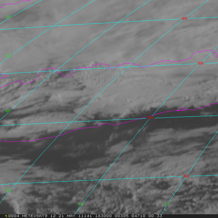 (Click image to enlarge)
Figure caption: Meteosat-9 visible channel images showed the volcanic eruption cloud emanating from the Grímsvötn volcano in Iceland on 21 May 2011 (images courtesy of Dave Santek, SSEC). According to the Icelandic Met Office, at 21:00 UTC the eruption plume had risen to an altitude of over 65,000 ft (~20 km).
 (Click image to enlarge)
NEXT WEEK:
LOOKING AHEAD:
| Archived Weeklies Page | Submit a report item |