
[ Archive ]

|
ASPB and CIMSS Weekly Report
[ Archive ] |
|
IN THE PRESS:
ITEMS FOR THE ADMINISTRATOR:
ITEMS FOR THE ASSISTANT ADMINISTRATOR:
ITEMS FOR THE OFFICE DIRECTOR, STAR:
McIDAS Training for Staff from Weather Service of Mexico: For the week of 3-7 October 2011, H. Hernández Peralta, J. C. Ramos Soto, and H. Lara, representing the Servicio Meteorologico Nacional (SMN) in Mexico City, visited the University of Wisconsin-Madison (UW) Space Science and Engineering Center (SSEC) to receive training on the Man computer Interactive Data Access System (McIDAS) as well as satellite applications. R. Kohrs, J. Heinzelman, and J. Beavers (SSEC) led the training for both the traditional (Linux-based) McIDAS-X software as well as the more recently developed, visualization-focused (fifth generation) McIDAS-V software. Cooperative Institute for Meteorological Satellite Studies (CIMSS) staff provided presentations on a number of satellite applications, and their usage in McIDAS: G. S. Wade (NOAA ASPB) on the Geostationary Operational Environmental Satellite (GOES) Sounder products; S. Wanzong (CIMSS), on the determination of cloud drift winds from satellites; and K. Strabala (CIMSS), on products from the NASA MODerate resolution Imaging Spectroradiometer (MODIS) instrument. H. Hernández Peralta expressed interest in seeking better GOES Sounder coverage over Mexico; currently the East and West GOES coverage provided by NOAA excludes southwest and central Mexico. (B. Schaffer, SSEC, 608-263-6141, becky.schaffer@ssec.wisc.edu; G. S. Wade, E/RA2, 608-264-4743, gary.s.wade@noaa.gov)
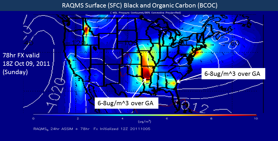
Aerosol Forecasting Support for NASA DEVOTE Mission: Aerosol
forecasts from the Real-time Air Quality Modeling System (RAQMS) are
currently being used by the NASA DEVOTE (Development and Evaluation of
satellite ValidatiOn Tools by Experimenters) project (http://www-air.larc.nasa.gov/missions/devote/devote.html)
to help plan research flights to sample smoke from agricultural fires
in the lower Mississippi River valley and Gulf Coast. DEVOTE is a
collaboration between NASA Langley Research Center, Goddard Space Flight
Center, and University of Maryland, Baltimore county that uses research
flights from the NASA Langley UC-12 aircraft to measure aerosol and
cloud optical and microphysical parameters. DEVOTE measurements will be
used for evaluating advanced aerosol retrieval satellite algorithms
using combined lidar and polarimeter data. (R.B. Pierce, E/RA2,
608-890-1892, brad.pierce@noaa.gov, T. Schaack, SSEC, A. Lenzen, SSEC)
 (Click image to enlarge)
ITEMS FOR THE DIVISION CHIEF, CoRP:
VISITORS:
NEXT WEEK:
LOOKING AHEAD:
| Archived Weeklies Page | Submit a report item |