
[ Archive ]

|
ASPB and CIMSS Weekly Report
[ Archive ] |
|
IN THE PRESS:
ITEMS FOR THE ADMINISTRATOR:
ITEMS FOR THE ASSISTANT ADMINISTRATOR:
ITEMS FOR THE OFFICE DIRECTOR, STAR:
NASA and NOAA Honor Suomi in Renaming the NPP Satellite: NASA
and NOAA renamed their newest Earth-observing satellite after Verner
Suomi, a longtime University of Wisconsin-Madison professor who often is
called the father of satellite meteorology. The National Polar-orbiting Operational Environmental Satellite System
Preparatory Project (NPP) satellite is now named Suomi NPP -- the Suomi
National Polar-orbiting Partnership. Suomi, who died in 1995, spent
nearly his entire career at UW-Madison. He may be best known for the
spin-scan camera, which allowed satellites in stationary orbit of one
point on Earth to maintain continuous focus and enable, among other
capabilities, the instant-replay-style weather images that are used on
television. The UW-Madison press release is at
http://www.news.wisc.edu/20240. (J. Key, E/RA2, 608-263-2605,
jkey@ssec.wisc.edu)
Two SWIPA Papers Published: A special issue
of the scientific journal AMBIO contains papers based on various components of
the the Arctic Council initiative “Snow, Water, Ice, and Permafrost in
the Arctic” report. SWIPA is an assessment of recent changes in the Arctic
cryosphere. J. Key co-authored two of the papers: "The changing Arctic
cryosphere and likely consequences: An overview" (Olsen et al., Ambio,
40, 111-118) and "Feedbacks and interactions: From the Arctic cryosphere
to the climate system" (Callaghan et al., Ambio, 40, 75-86). (J. Key,
E/RA2, 608-263-2605, jkey@ssec.wisc.edu)
AMS Annual Meeting: The Cooperative Institute for Meteorological Satellite Studies (CIMSS) and the NESDIS/STAR Advanced Satellite Products Branch (ASPB) had 58 presentations and posters at the the annual meeting of the American Meteorological Society (AMS) held in New Orleans, Louisiana. The 35 oral presentations and 23 posters covered algorithm development, data assimilation, modeling and impacts, visualization, meteorological stidues, climate datasets and analyses, instruments, validation, and training. From ASPB, Tim Schmit spoke on the status of the Advanced Baseline Imager (ABI) and the work done on simulating it before launch; Michael Pavolonis gave talks on algorithms and applications of fog and volcanic ash retrievals; Andy Heidinger presented the new cloud climate data from Geostationary Operational Environmental Satellite (GOES) data and its ability to improve the long-term Polar Orbiting Environmental Satellite (POES) records. Tim Schmit served as a co-chair of the Eighth Symposium on Future Operational Environmental Satellite Systems. Michael Pavolonis and Tim Schmit were interviewed as part of the NOAA 'Big Picture' event (http://www.nnvl.noaa.gov/BigPictureGallery.php). (A. Heidinger, E/RA2, 608-263-6757, M. Pavolonis, E/RA2, 608-263-9597, T. Schmit, E/RA2, 608-263-0291)
ITEMS FOR THE DIVISION CHIEF, CoRP:
First Light CrIS Observations: The Crosstrack Infrared Sounder (CrIS) signal processors were turned on at 7:48 Eastern time on 20 January 2012. Raw data was received at the University of Wisconsin Space Science and Engineering Center (SSEC) via the NPP Atmospheres Product Evaluation and Test Element (PEATE) at SSEC and then processed with the CrIS Calibration Algorithm and Sensor Testbed (CCAST), developed jointly by CrIS Cal/Val colleagues at UW and the University of Maryland Baltimore County (UMBC), to produce calibrated/geolocated radiance spectra. Sample figures show global images of 900 1/cm brightness temperature, and sample spectra. (D. Tobin, CIMSS, 608-265-6281)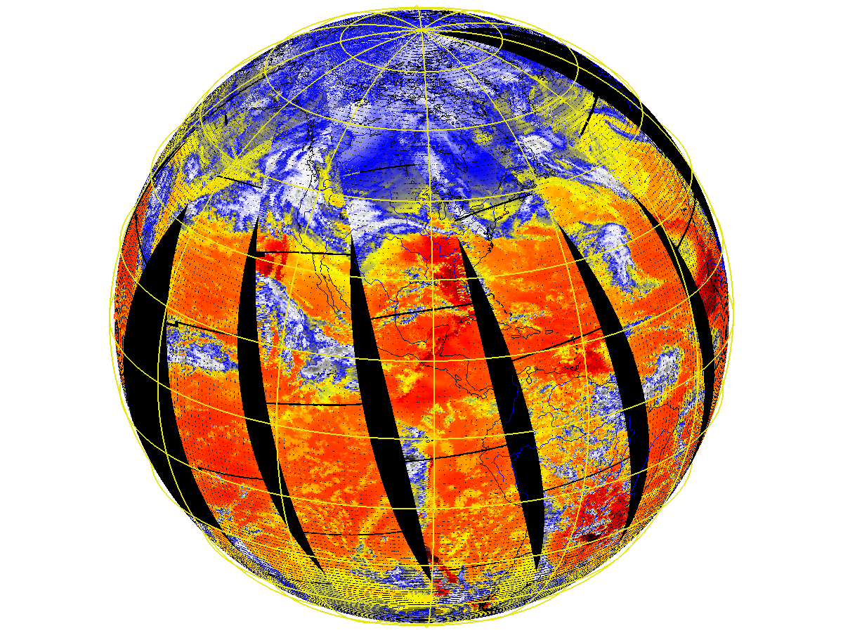 (Click image to enlarge)
 (Click image to enlarge)
VISITORS:
NEXT WEEK:
LOOKING AHEAD:
| Archived Weeklies Page | Submit a report item |