 |
ASPB and CIMSS Weekly Report
[ Archive ] |
 |
ASPB AND CIMSS WEEKLY HIGHLIGHTS FOR THE WEEK ENDING FEBRUARY 4, 2012
IN THE PRESS:
ITEMS FOR THE ADMINISTRATOR:
ITEMS FOR THE ASSISTANT ADMINISTRATOR:
ITEMS FOR THE OFFICE DIRECTOR, STAR:
ITEMS FOR THE DIVISION CHIEF, CoRP:
Annual IIPS Conference: The 28th annual conference on Interactive Information and Processing Systems (IIPS) was held during the week of 23 January, in conjunction with the annual meeting of the American Meteorological Society. Tom Whittaker (CIMSS) again served as Program Chair for this conference, where nearly 300 presentations were made in more than 30 sessions. It should be noted that the AMS has moved the IIPS to be under the Scientific and Technological Activities Commission (STAC) as a Board. The name has been also been changed, so the 2013 meeting will be titled the 29th Environmental Information Processing Technologies (EIPT) conference. (T. Whittaker, CIMSS, 608-262-2759).
Manuscript on Infrared Radiance Assimilation Published: A
manuscript entitled “Assessing the impact of the covariance
localization radius when assimilating infrared brightness temperature
observations using an ensemble Kalman filter” was published in the
February issue of Monthly Weather Review. The paper by Jason
Otkin (Cooperative Institute for Meteorological Satellite Studies,
CIMSS) presented results from a regional-scale Observing System
Simulation Experiment (OSSE) that was used to examine the impact of the
horizontal covariance localization radius employed during the
assimilation of clear and cloudy-sky 8.5 μm brightness temperatures in
an Ensemble Kalman Filter data assimilation system. (J. Otkin, CIMSS, 608-265-2476)
Directing GOES-based Convective Initiation to Operations: On 30 January 2012, at the Satellite Product and Services Review Board (SPSRB) Process Improvement Working Group (SPI WG) meeting, a report was provided describing the work done to try to quantitatively compare two versions of Convective Initiation (CI) products derived from Geostationary Operational Environmental Satellites (GOES). A satellite-based CI product had previously been requested by a National Weather Service (NWS) office, and the two reasonable options were algorithms from the University of Alabama-Huntsville and from the University of Wisconsin-Madison. Real-time data from both algorithms had been provided to the NWS Storm Prediction Center (SPC) in Norman, OK as part of the Hazardous Weather Testbed (HWT) of the GOES-R Proving Ground effort in May and June 2011, and were statistically compared, to a radar-based CI product, by V. Lakshmanan (University of Oklahoma). However, the satellite and radar match-up concept was deficient and did not yield legitimate statistics. The two algorithms were comparable but different, with neither showing any fatal flaws. The SPI WG decided to go back to the NWS to obtain more useful requirements information, to help in selecting one algorithm to transition into operations. (G. S. Wade, E/RA2, 608-263-4743, gary.s.wade@noaa.gov)
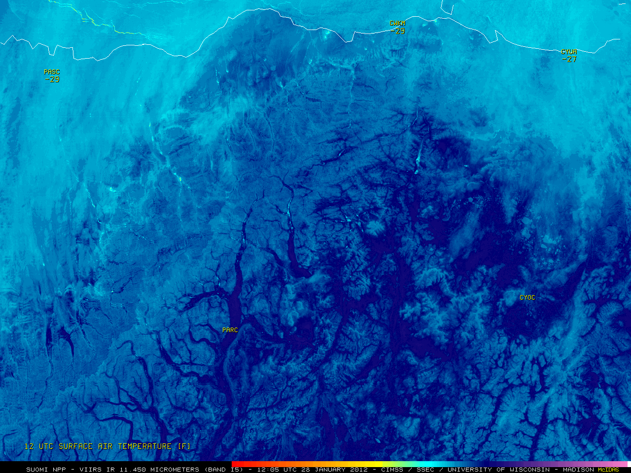
CIMSS VISIT Activities: The Virtual Institute for Satellite Integration Training (VISIT) session "Cooperative Institute for Meteorological Satellite Studies (CIMSS) Regional Assimilation System (CRAS) Forecast Imagery in Advanced Weather Information Processing System (AWIPS)" (http://rammb.cira.colostate.edu/training/visit/training_sessions/trowal_identification/) was led by S. Lindstrom on January 31, 2012. Staff from the National Weather Service forecast office at Riverton, Wyoming participated in the VISIT lesson. In addition, the CIMSS Satellite Blog was updated with new posts containing a variety of Geostationary Operational Environmental Satellite (GOES), Polar Operational Environmental Satellite (POES) Advanced Very High Resolution Radiometer (AVHRR), Moderate Resolution Imaging Spectroradiometer (MODIS), and Suomi National Polar-orbiting Partnership (NPP) Visible Infrared Imaging Radiometer Suite (VIIRS) images showing an anomalously large dry region aloft over the central Pacific Ocean (http://cimss.ssec.wisc.edu/goes/blog/archives/9697), the "hot spot" from a fire that may have caused a fatal traffic accident in Florida (http://cimss.ssec.wisc.edu/goes/blog/archives/9686), and signatures of cold air drainage into lower elevations in Alaska (http://cimss.ssec.wisc.edu/goes/blog/archives/9672). (S. Lindstrom, CIMSS, 608-263-4425, S. Bachmeier, CIMSS, 608-263-3958)
 (Click image to enlarge)
Figure caption: 375-meter resolution Suomi NPP VIIRS 10.450 µm IR image showing the signature of cold air drainage (darker blue enhancement) into lower elevation terrain such as the relatively narrow river valleys along the south side of the Brooks Range in Alaska on January 28, 2012.
VISITORS:
NEXT WEEK:
LOOKING AHEAD: