
[ Archive ]

|
ASPB and CIMSS Weekly Report
[ Archive ] |
|
IN THE PRESS:
GOES-R Highlighted in NASA Science News: The Geostationary Lightning Mapper (GLM) and Advanced Baseline Imager (ABI) were highlighted in NASA Science News. The article is titled "Next-Gen Weather Satellites to Improve Tornado Warnings" (http://science.nasa.gov/science-news/science-at-nasa/2012/29feb_tornadosurprise/). T. Schmit and S. Goodman were quoted on Geostationary Operational Environmental Satellite (GOES)-R. (T. Schmit, E/RA2, Timothy.J.Schmit@noaa.gov)
ITEMS FOR THE ADMINISTRATOR:
ITEMS FOR THE ASSISTANT ADMINISTRATOR:
ITEMS FOR THE OFFICE DIRECTOR, STAR:
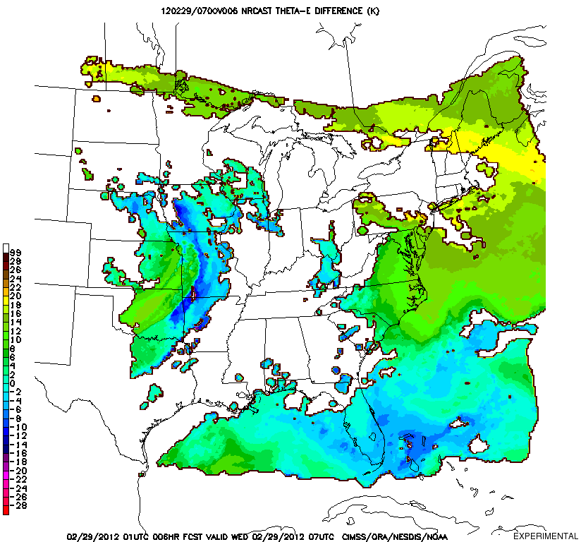
CIMSS Severe Weather Nearcasting Model Predicts Southern Missouri Storms: The
Cooperative Institute for Meteorological Satellite Studies (CIMSS) runs
a prediction model that "near-casts" (out to 9 hours) the potential for
the development of severe weather. The model is initialized hourly
using retrieved profiles of equivalent potential temperature from the
GOES-13 sounder, which are projected forward in time along trajectories
and then monitored for vertical destabilization. The 01 UTC run on
February 29 isolated an area of strong
destabilization near Branson, MO at 07 UTC (1:00 AM CST), six hours in
advance of the storms that spawned multiple tornadoes. Real-time
near-casting products can be viewed online at
http://cimss.ssec.wisc.edu/model/nrc/. (R. Aune, E/RA2, 608-262-1071).
 (Click image to enlarge)
Figure caption: 6-hour near-cast of equivalent potential temperature
lapse rate valid 07 UTC, February 29, 2012. Larger negative values
(purple or red) indicated the atmosphere becoming strongly unstable.
Velden Receives Chancellor's Award for Excellence in Research: Chris
Velden is the recipient of the University of Wisconsin Chancellor's
Award for Excellence in Research. This award, given to an independent
university researcher, recognizes a lifetime achievement for
significantly impacting their discipline. Velden's nomination package
included strong recommendations of support from international and
national institutions, including NOAA's National Hurricane Center. The
award will be presented in April at a special Chancellor's honors
ceremony. (J. Key, E/RA2, 608-263-2605, jkey@ssec.wisc.edu)
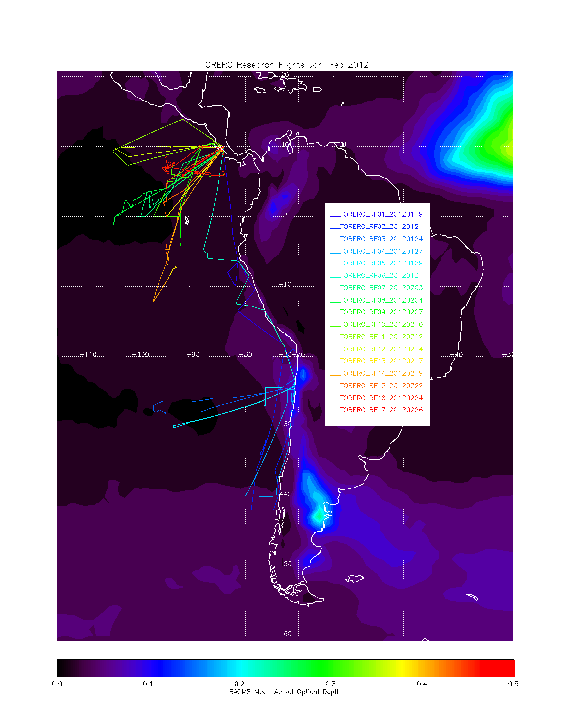
Field Phase of GOES-R TORERO Airborne Cal/Val Completed: The
data acquisition phase of the National Science Foundation (NSF)
Tropical Ocean Troposphere Exchange of Reactive halogen species and
Oxygenated volatile organic compounds (TORERO) mission (http://www.eol.ucar.edu/deployment/field-deployments/field-projects/torero)
was completed on February 28, 2012 with 17 successful research flights,
5 from Antofagasta, Chile and 12 from San Jose, Costa Rica. Data
collected during TORERO will be used by NESDIS and Cooperative Institute
for Meteorological Satellite Studies (CIMSS) scientists to validate
GOES-R Advanced Baseline Imager (ABI) cloud, aerosol and legacy sounding
products over the Equatorial Pacific. Scientists from the Advanced
Satellite Products Branch (ASPB) provided daily chemical and aerosol
forecasts using the Real-time Air Quality Modeling System (RAQMS) and
real-time cloud products from the AVHRR Pathfinder Atmospheres –
Extended (PATMOS-x) which were used extensively for flight planning
during TORERO. (R.B. Pierce, E/RA2, 608-890-1892, A. Heidinger, E/RA2,
608-263-6757, A. Walther, CIMSS, W. Feltz, CIMSS)
 (Click image to enlarge)
Figure caption: Map of TORERO research flights overlaid on the RAQMS
mean aerosol optical depth analysis during January 19th -February 28th,
2012.
ITEMS FOR THE DIVISION CHIEF, CoRP:
Beta testing of IDEA-I within IMAPP: A select group of Direct Broadcast users will begin beta testing of an open source, portable version of Infusing Satellite Data into Environmental Applications (IDEA), a satellite based aerosol forecasting, visualization, and data synthesis tool for use by the international air quality forecasting community. IDEA International (IDEA-I) is being released as part of the International Moderate Resolution Imaging Spectroradiometer (MODIS) Atmospheric Infrared Sounder (AIRS) Processing Package (IMAPP) and its operational follow-on the Community Satellite Processing Package (CSPP). IMAPP provides freely distributed science production software for MODIS and AIRS science data products; CSPP provides similar capability for the Visible Infrared Imaging Radiometer Suite (VIIRS), Cross-track Infrared Sounder (CrIS) and Advanced Technology Microwave Sounder (ATMS) on the Suomi National Polar-orbiting Partnership (Suomi NPP). IDEA-I supports the Global Earth Observation Systems of Systems (GEOSS) Group on Earth Observations (GEO) Health Societal Benefit Area (SBA) and has been developed within the framework of the GEO Earth Observations in Decision Support Call for Proposals (R.B. Pierce, E/RA2, 608-890-1892,K. Strabala, CIMSS, J. Davies, SSEC, E. Schiffer, CIMSS, R. Garcia, SSEC, A. Huang, CIMSS)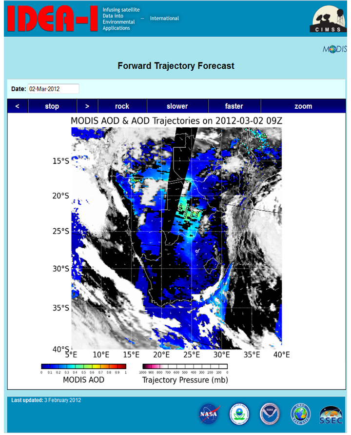 (Click image to enlarge)
NEXT WEEK:
LOOKING AHEAD:
| Archived Weeklies Page | Submit a report item |