
[ Archive ]

|
ASPB and CIMSS Weekly Report
[ Archive ] |
|
IN THE PRESS:
Short Video on the Evolution of GOES: A
short video on the evolution of the Geostationary Operational
Environmental Satellite (GOES) was produced by the NOAA NESDIS
Visualization Laboratory (NNVL). Tim Schmit was interviewed as part of
the NOAA 'Big Picture' event at annual American Meteorological Society
(AMS). The video can be seen at
http://www.nnvl.noaa.gov/MediaDetail2.php?MediaID=1019&MediaTypeID=3&ResourceID=104501
or several other locations. (T. Schmit, E/RA2,
Timothy.J.Schmit@noaa.gov)
 (Click image to enlarge)
Figure caption: Top of the NOAA Facebook page on 22 March 2012.
ITEMS FOR THE ADMINISTRATOR:
ITEMS FOR THE ASSISTANT ADMINISTRATOR:
ITEMS FOR THE OFFICE DIRECTOR, STAR:
Support to NWS in Hawaii During GOES-15 Outage: To
help mitigate the temporary loss of Geostationary Operational
Environmental Satellite (GOES)-15 imagery during an outage between 21
and 23 March 2012, the Cooperative Institute for Meteorological
Satellite Studies (CIMSS) supplied imagery from four polar-orbiting
satellites to the National Weather Service (NWS) Weather Forecast Office
(WFO) in Honolulu, Hawaii. The Science Operations Officer (SOO) of WFO
Honolulu specifically made the request shortly after the outage
occurred; imagery was transmitted from CIMSS to the WFO shortly
thereafter. With limited in-situ weather observations from the Pacific
Ocean, WFO Honolulu relies heavily on satellite imagery for weather
forecasting, and the SOO said the additional data from CIMSS was "super
helpful". Evidence that supports the value of polar-orbiting imagery as
a supplement to GOES imagery is available at
http://cimss.ssec.wisc.edu/goes/blog/archives/10039. The NWS WFO
Honolulu homepage, which carried information on the loss GOES-15
imagery, is http://www.prh.noaa.gov/pr/hnl/. (T. Schmit, E/RA2,
608-263-0291, tim.j.schmit@noaa.gov, J. Gerth, CIMSS, 608-263-4942, S.
Bachmeier, CIMSS, 608-263-3958)
ITEMS FOR THE DIVISION CHIEF, CoRP:
Participation in 2012 EUMETSAT Organizational Committee Planning Meeting: Wayne Feltz (Cooperative Institute for Meteorological Satellite Studies, CIMSS) participated in planning the 2012 EUMETSAT (European Organisation for the Exploitation of Meteorological Satellites) conference as U.S. representative on 22-23 in Sopot, Poland. The main focus was providing oral and poster presentation guidance for a session titled "Current and Future Satellites, Instruments and their Applications". (W. Feltz, CIMSS, 608-265-6283)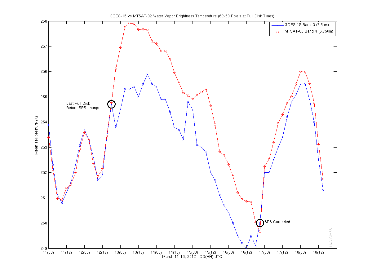 (Click image to enlarge)
VISITORS:
NEXT WEEK:
LOOKING AHEAD:
| Archived Weeklies Page | Submit a report item |