
[ Archive ]

|
ASPB and CIMSS Weekly Report
[ Archive ] |
|
IN THE PRESS:
GOES-R Volcanic Ash Products Featured in Article: The
Next generation Geostationary Operational Environmental Satellite
(GOES-R) volcanic ash products were featured in an article in the May
2012 issue of “Meteorological Technology International,” which is a
publication dedicated to the latest developments in climate, weather and
hydrometeorological forecasting, measurement and analysis technologies
and service providers. The article, written by Steve Albersheim and
Larry Burch of the Federal Aviation Administration (FAA), describes
recent progress made on establishing safety guidelines for aircraft
operations in environments that may be contaminated with volcanic ash.
The GOES-R volcanic ash products are highlighted as one of the tools
needed to determine flight safety risks. (M. Pavolonis, E/RA2,
608-263-9597, Mike.Pavolonis@noaa.gov)
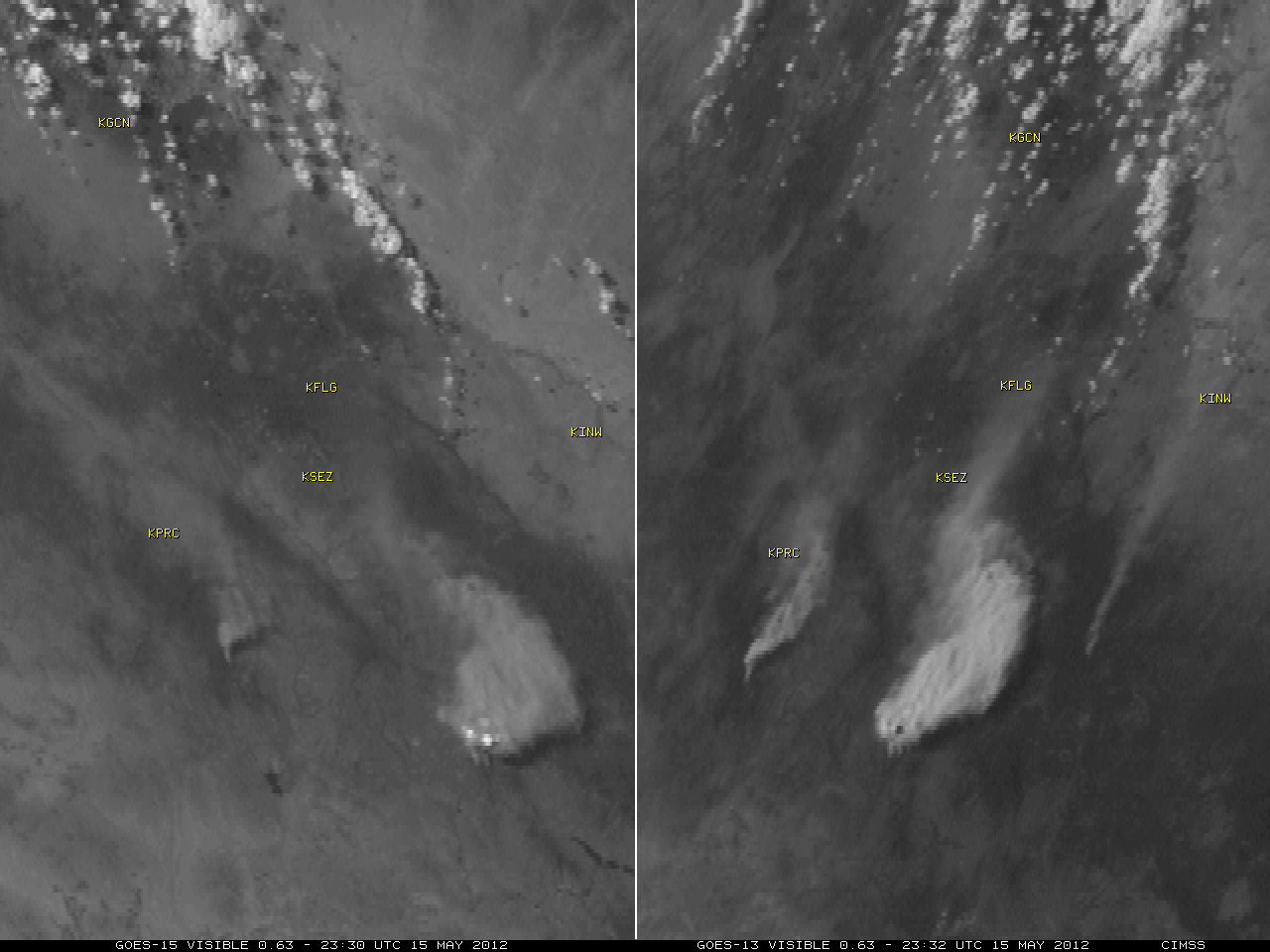
GOES Images of Arizona Wildfires Appear on NBC Nightly News: A
comparison of Geostationary Operational Environmental Satellite
(GOES-15 and GOES-13) visible channel images showing pyrocumulus clouds
and a thick smoke plume associated with a large wildfire burning in
Arizona was posted on the Cooperative Institute for Meteorological
Satellite Studies (CIMSS) Satellite Blog
(http://cimss.ssec.wisc.edu/goes/blog/archives/10359). This GOES imagery
also appeared on a NBC Nightly News segment covering the Arizona fires
on May 17, 2012 (http://go.wisc.edu/eqt85d). (S. Bachmeier, CIMSS,
608-263-3958)
 (Click image to enlarge)
Figure caption: GOES-15 (left) and GOES-13 (right) visible channel
images showing pyrocumulus clouds and a thick smoke plume associated
with the "Sunflower Fire" in Arizona on May 15, 2012. Due to the
different satellite viewing angles, the overshooting tops of the
pyrocumulus clouds were brightly illuminated on the GOES-15 image, while
casting a distinct shadow onto the top of the cloud/smoke plume on the
GOES-13 image.
ITEMS FOR THE ADMINISTRATOR:
ITEMS FOR THE ASSISTANT ADMINISTRATOR:
ITEMS FOR THE OFFICE DIRECTOR, STAR:
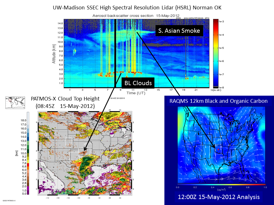
Deep Convective Clouds and Chemistry (DC3) Field Campaign: Science
flights for the National Science Foundation (NSF) Deep Convective
Clouds and Chemistry (DC3) field campaign are now underway (http://www.eol.ucar.edu/projects/dc3/).
Data collected during DC3 will be used to validate GOES-R Advanced
Baseline Imager (ABI) cloud and aerosol retrievals under support from
the GOES-R Cal/Val program. Advanced Satellite Products Branch (ASPB)
and University of Wisconsin-Madison Space Science and Engineering Center
(SSEC) scientists are providing real-time High Spectral Resolution
Lidar (HSRL) measurements, AVHRR Pathfinder Atmospheres-Extended
(PATMOS-X) cloud retrievals, and Real-time Air Quality Modeling System
(RAQMS) chemical forecasts to the DC3 mission scientists to assist in
flight planning. DC3 investigates the impact of deep, midlatitude
continental convective clouds on upper tropospheric composition and
chemistry with research flights in Oklahoma, Texas, Colorado, and
Alabama. The SSEC HSRL instrument has been deployed to the National
Severe Storms Laboratory (NSSL) in Norman OK and is being hosted by Dave
Turner at NSSL (R.B. Pierce, E/RA2, 608-890-1892, A. Heidinger, E/RA2,
W. Feltz, CIMSS, E. Eloranta, SSEC, D. Turner, NSSL)
 (Click image to enlarge)
Figure caption: May 15, 2012 HSRL backscatter cross section measurements
in Norman, OK show Planetary Boundary Layer (PBL) aerosols, cloud
formation at the top of the PBL (3km), and upper tropospheric (10-12km)
aerosol enhancements on May 15, 2012. The 08:45Z PATMOS-X GOES Cloud Top
Height retrievals over Norman, OK show very good agreement with the
HSRL PBL cloud top heights. RAQMS 12Z black and organic carbon aerosol
analyses show that the upper tropospheric aerosol enhancements are
associated with Trans-Pacific transport of pollution from S. Asian
biomass burning.
GOES-R Near-casting Demonstrated at the Hazardous Weather Testbed (HWT): R. Aune and J. Gerth (CIMSS) supported the Hazardous Weather Testbed this week at the National Weather Service's Storm Prediction Center (SPC), Norman, Oklahoma. While there, they assisted NWS forecasters with interpreting near-casting products generated by the GOES Sounder near-casting model running at the Cooperative Institute for Meteorological Satellite Studies (CIMSS) (See http://cimss.ssec.wisc.edu/model/nrc/). Forecasters found the nearcasted stability parameters to be very useful in locating areas where convective storms were most likely to form and were not likely to form, up to six hours in advance. A new parameter derived from the nearcast, Convective Available Potential Energy (CAPE), was introduced and well received. (R. Aune, E/RA2, 608-262-1071, J. Gerth, CIMSS, 608-263-4942)
ITEMS FOR THE DIVISION CHIEF, CoRP:
GOES-13 Imager Infrared Band Co-registration Issue: The Cooperative Institute for Meteorological Satellite Studies (CIMSS) found an issue on the GOES-13 Imager regarding the co-registration between infrared (IR) bands 2 (3.9 um) and 4 (10.7 um). Working with the Advanced Satellite Products Branch (ASPB), this information was confirmed and passed to the proper authorities, along with noting the operational products potentially effected. The shift between bands can be as large as one IR pixel (4 km), while the specification is a quarter pixel. Apparently a GOES Incident Report (GIR) is being considered. More information can be found at http://cimss.ssec.wisc.edu/goes/blog/archives/10341. (S. Lindstrom, CIMSS; S. Bachmeier, CIMSS, 608-263-3958; C. Schmidt, CIMSS, 608-262-7973; T. Schmit, E/RA2, 608-263-0291, tim.j.schmit@noaa.gov)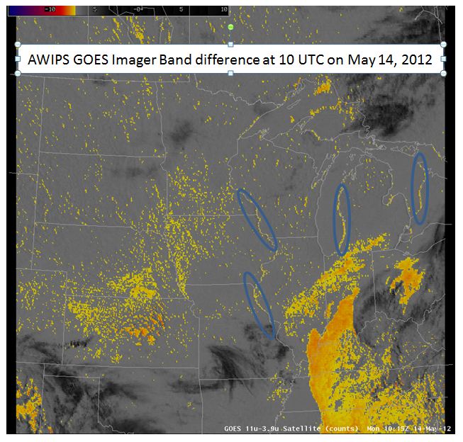 (Click image to enlarge)
Figure caption: GOES Imager band difference at 10 UTC on May 14, 2012 displayed in AWIPS. Many points show artificial differences due to the band co-registration offset.
VISITORS:
NEXT WEEK:
LOOKING AHEAD:
| Archived Weeklies Page | Submit a report item |