
[ Archive ]

|
ASPB and CIMSS Weekly Report
[ Archive ] |
|
IN THE PRESS:
Live Weather Channel Interviews: The Weather Channel interviewed Jim Kossin (NCDC/RSAD) about a new model recently adopted by the National Hurricane Center to help predict hurricane eyewall replacement cycles. There were two interviews that took place on 6 June 2012. The second interview is available at http://www.weather.com/weather/videos/storms-42/hurricanes-213/keeping-an-eye-on-the-eyewall-29038. (J. Kossin, NCDC/RSAD, 608-265-5356)
ITEMS FOR THE ADMINISTRATOR:
ITEMS FOR THE ASSISTANT ADMINISTRATOR:
ITEMS FOR THE OFFICE DIRECTOR, STAR:
Second Meeting of the Polar Space Task Group: The
World Meteorological Organization's (WMO) Polar Space Task Group (PSTG)
is a continuation of the Space Task Group for the International Polar
Year (IPY-STG) that was formed in 2006. The PSTG was established for the
purpose of space agency planning, processing, and archiving of
satellite products covering, or relevant to, the polar regions. All
major space agencies have representatives on the PSTG. The second PSTG
meeting was held in Geneva, Switzerland, 12-14 June 2012. Jeff Key
attended as the NESDIS representative and PSTG Vice-Chair. He reported
on NOAA’s current work on cryosphere and atmosphere products from the
NPP satellite. (J. Key, E/RA2, 608-263-2605, jkey@ssec.wisc.edu)
NASA Air Quality Applied Science Team Meeting: The Cooperative Institute for Meteorological Satellite Studies (CIMSS) and the Center for Sustainability and the Global Environment (SAGE) at the University of Wisconsin-Madison hosted the 3rd NASA Air Quality Applied Science Team (AQAST) meeting in Madison, WI on June 13-15, 2012 (http://www.ssec.wisc.edu/meetings/aqast/). AQAST works in partnership with air quality agencies at the local, state, regional, and national levels to address air quality management issues through the use of Earth Science data and models. The 3rd AQAST meeting focused on air quality management issues in the Midwestern states and included representatives from the Wisconsin Department of Natural Resources and Lake Michigan Air Directors Consortium (LADCO) which addresses air quality issues in Illinois, Indiana, Michigan, Wisconsin, and Ohio. (R.B. Pierce, E/RA2, 608-890-1892, brad.pierce@noaa.gov)
ITEMS FOR THE DIVISION CHIEF, CoRP:
CIMSS Satellite Proving Ground Activities for NOAA Testbeds: The Cooperative Institute for Meteorological Satellite Studies (CIMSS) and and the STAR Advanced Satellite Products Branch (ASPB) concluded five weeks of participation at the Norman, Oklahoma NOAA Hazardous Weather Testbed (HWT) and two weeks at the Kansas City, MO Aviation Weather Testbed this week. CIMSS is providing convective cloud top cooling rate, nearcasting, and Weather Research Forecasting (WRF) model simulated geostationary satellite decision support products for forecaster evaluation at HWT as part of the NOAA GOES-R Proving Ground project. In parallel, CIMSS is providing satellite derived cloud top height, cloud type, fog/low cloud, convective cloud top cooling rate, nearcasting, overshooting-top/enhanced-V, and WRF simulated geostationary satellite decision support products for use in evaluation of impact on commercial aviation route planning. Forecaster feedback is available from the following blog internet sites: http://goesrawt.blogspot.com/ and http://goesrhwt.blogspot.com/. (W. Feltz, CIMSS, 608-265-6283)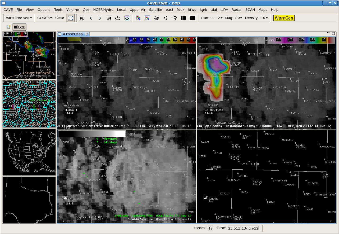 (Click image to enlarge)
VISITORS:
NEXT WEEK:
LOOKING AHEAD:
| Archived Weeklies Page | Submit a report item |