 |
ASPB and CIMSS Weekly Report
[ Archive ] |
 |
ASPB AND CIMSS WEEKLY HIGHLIGHTS FOR THE WEEK ENDING SEPTEMBER 15, 2012
IN THE PRESS:
ITEMS FOR THE ADMINISTRATOR:
ITEMS FOR THE ASSISTANT ADMINISTRATOR:
ITEMS FOR THE OFFICE DIRECTOR, STAR:
ITEMS FOR THE DIVISION CHIEF, CoRP:
Forecaster Training in Alaska: Mike Pavolonis (NOAA/NESDIS/STAR) and Corey Calvert (Cooperative Institute for Meteorological Satellite Studies, CIMSS) visited National Weather Service (NWS) offices in Fairbanks and Anchorage, AK. The main goal of the visit was to train forecasters on the use of fog/low cloud and volcanic ash products developed by the next generation Geostationary Operational Environmental Satellite (GOES-R) Algorithm Working Group (AWG). Over 20 forecasters attended group training sessions and/or individual training sessions. In addition, M. Pavolonis met with colleagues at the University of Alaska – Fairbanks and the United States Geological Survey (USGS) Alaska Volcano Observatory (AVO) to discuss ongoing collaborations. (M. Pavolonis, E/RA2, 608-263-9597, Mike.Pavolonis@noaa.gov, C. Calvert, CIMSS)
Data Collection of Special 1-min GOES-14 Scans Continues: The data collection phase of the special 1-min scans from the Geostationary Operational Environmental Satellite (GOES)-14 imager continues. Many phenomena (convection, hurricanes, fires, smoke, etc.) have been captured. More information, including daily coverage maps, can be found at http://cimss.ssec.wisc.edu/goes/srsor/GOES-14_SRSOR.html. Other animations can be found at http://cimss.ssec.wisc.edu/goes/blog/archives/category/goes-14, for example, an animation comparing the operational image cadence to GOES-R like time resolutions: http://cimss.ssec.wisc.edu/goes/blog/wp-content/uploads/2012/09/g13_g14_loop.mov. (S. Lindstrom, CIMSS; S. Bachmeier, CIMSS, 608-263-3958; T. Schmit, E/RA2, 608-263-0291, tim.j.schmit@noaa.gov; Steve Goodman, GOES-R Project Office)
CIMSS VISIT Activities: S. Lindstrom participated in two Virtual Institute for Satellite Integration Training (VISIT) Satellite Chat sessions on "Satellite views of severe and tropical weather" (see http://rammb.cira.colostate.edu/training/visit/satellite_chat/) on September 12, 2012. In addition, the Cooperative Institute for Meteorological Satellite Studies (CIMSS) Satellite Blog (http://cimss.ssec.wisc.edu/goes/blog/) was updated with a number of posts on topics such as Tornadoes in metropolitan New York City, Evidence of cool upwelled water in the wake of Leslie, Heavy rainfall and flooding in Las Vegas, Nevada, Super Typhoon Sanba, and Geostationary Operational Environmental Satellite (GOES-14) full disk images at 30-minute intervals. (S. Lindstrom, CIMSS, 608-263-4425, S. Bachmeier, CIMSS, 608-263-3958)
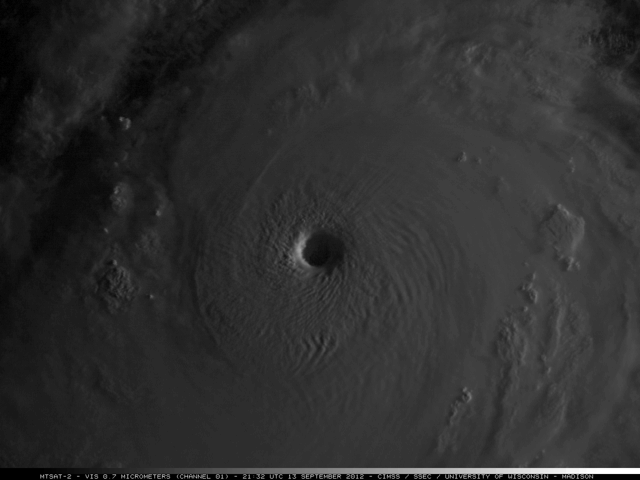 (Click image to enlarge)
Figure caption: MTSAT-2 0.7 µm visible channel image showing the large, well-defined eye of Super Typhoon Sanba on September 13, 2012.
VISITORS:
NEXT WEEK:
LOOKING AHEAD: