
[ Archive ]

|
ASPB and CIMSS Weekly Report
[ Archive ] |
|
IN THE PRESS:
Velden Interviewed by NPR: Chris Velden,
Cooperative Institute for Meteorological Satellite Studies, was
interviewed by National Public Radio (NPR) on the subject of hurricane
forecasting. The article, titled "Computers, Pinch Of Art Aid Hurricane
Forecasters", is online at
http://www.npr.org/2012/10/26/163725684/computers-pinch-of-art-aid-hurricane-forecasters.
(J. Key, E/RA2, 608-263-2605, jkey@ssec.wisc.edu; J. Phillips, SSEC)
STAR/CIMSS Volcanic Ash Research Spotlighted by NOAA Research Council: Volcanic ash remote sensing research being conducted by Mike Pavolonis (NOAA/NESDIS/STAR) and Justin Sieglaff (Cooperative Institute for Meteorological Satellite Studies, CIMSS) was featured in a NOAA Research Council “Cooperative Institute in the Spotlight” article (http://www.nrc.noaa.gov/ci/hotitems/2012/cimss-10.html). The article highlights how satellite derived volcanic ash cloud products, developed by STAR and CIMSS, are being used to improve operational volcanic cloud monitoring. (M. Pavolonis, E/RA2, 608-263-9597, Mike.Pavolonis@noaa.gov, J. Sieglaff, CIMSS)
ITEMS FOR THE ADMINISTRATOR:
ITEMS FOR THE ASSISTANT ADMINISTRATOR:
ITEMS FOR THE OFFICE DIRECTOR, STAR:
Special 1-min GOES-14 Scans of Hurricane Sandy: Data
collection continues with special 1-min scans from the Geostationary
Operational Environmental Satellite (GOES)-14 imager of Hurricane Sandy.
Imagery is expected until October 31, 2012. More information, including
daily coverage maps, can be found at
http://cimss.ssec.wisc.edu/goes/srsor/GOES-14_SRSOR.html. Images and
animations can be found at
http://cimss.ssec.wisc.edu/goes/blog/archives/11644, for example, an
animation from October 26, 2012:
http://cimss.ssec.wisc.edu/goes/srsor/1080x1920_GOES_B1_RSRSO_SANDY_animated_2012300_141500_182_2012300_181100_182_X.mov.
The data is acquired by the Space Science and Engineering Center (SSEC)
Data Center and provided to many other users. (T. Schmit, E/RA2,
608-263-0291, tim.j.schmit@noaa.gov; S. Bachmeier, CIMSS, 608-263-3958)
NOAA ESRL Seminar: Brad Pierce visited the NOAA Earth Systems Research Laboratory (ESRL) Chemical Science Division (CSD) in Boulder, CO to present a seminar entitled “Forecasting Stratospheric Intrusion Events over the Western US for Exceptional Event Demonstration”. This seminar presented results from recent modeling studies that utilized global ozone analyses from the Real-time Air Quality Modeling System (RAQMS) which were used to initialize high resolution (8km) Weather Research and Forecasting – Chemistry (WRF-CHEM) regional predictions of stratospheric intrusion (SI) events that occurred during May-June 2012. This work supports the Environmental Protection Agency (EPA) SI working group, which was formed to develop standardized technical methods for analysis of SI, promote collaboration and data sharing between the states, academics and federal researchers, and promote archiving of key data sets. Potential OAR/NESDIS collaboration during the 2013 Southeast Nexus (SENEX) field mission was also discussed with CSD scientists during this visit. SENEX will focus on studying the interactions between natural and anthropogenic emissions at the nexus of climate change and air quality and will be conducted over the Southeastern US during June-July 2013 (R.B. Pierce, E/RA2, 608-890-1892, brad.pierce@noaa.gov)
ITEMS FOR THE DIVISION CHIEF, CoRP:
Metop-B AVHRR Data Included in Polar Winds Processing: Satellite-derived winds from Advanced Very High Resolution Radiometer (AVHRR) images are generated routinely at the Cooperative Institute for Meteorological Satellite Studies (CIMSS) using data from four NOAA satellites (NOAA-15, -16, -18, -19), and Metop-A. This polar winds product has been updated to include the use of AVHRR data from the recently launched Metop-B satellite. Also, Metop-B AVHRR is now incorporated into the generation of the Leo/Geo winds product. Plots of wind data are available at http://stratus.ssec.wisc.edu/products/rtpolarwinds/. (D. Santek, CIMSS, 608-263-7410; J. Key, E/RA2, 608-263-2605, jkey@ssec.wisc.edu)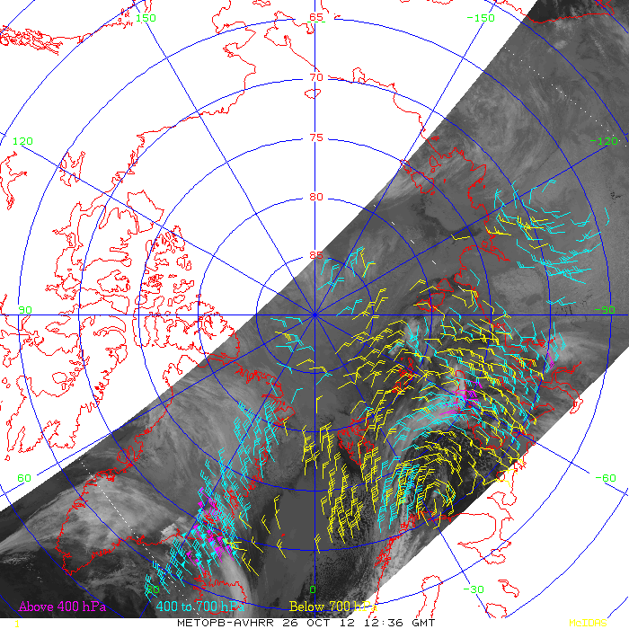 (Click image to enlarge)
GOES-R Proving Ground Training at Local NWS Weather Forecast Office: On October 26 2012, Michael Pavolonis (NOAA/NESDIS/STAR) and Corey Calvert (Cooperative Institute for Meteorological Satellite Studies, CIMSS) joined National Weather Forecast (NWS) forecaster Steve Davis for a training shift at the Weather Forecast Office (WFO) in Sullivan, Wisconsin (designation of MKX) in support of the next Generation Operational Environmental Satellite (GOES-R) Proving Ground. Given the foggy weather conditions over the majority of the eastern half of the continental United States on October 26, most of the time was spent using the fog/low cloud products developed by the GOES-R Algorithm Working Group (AWG) to determine the spatial extent of the low clouds and to predict fog dissipation time. Steve Davis indicated that the GOES-R AWG fog/low cloud products add value to short-term forecasts (e.g., http://goesrhwt.blogspot.com/2012/10/goes-r-awg-foglow-cloud-products.html). (M. Pavolonis, E/RA2, 608-263-9597, Mike.Pavolonis@noaa.gov, C. Calvert, CIMSS, S. Davis, Steve.Davis@noaa.gov)
VISITORS:
NEXT WEEK:
LOOKING AHEAD:
| Archived Weeklies Page | Submit a report item |