
[ Archive ]

|
ASPB and CIMSS Weekly Report
[ Archive ] |
|
IN THE PRESS:
ITEMS FOR THE ADMINISTRATOR:
ITEMS FOR THE ASSISTANT ADMINISTRATOR:
Meeting of the WMO Task Team on WIGOS Regulatory Material: The
World Meteorological Organization's (WMO) Inter-Commission Coordination
Group on the WMO Integrated Global Observing System (ICG-WIGOS)
recently formed a Task Team on WIGOS Regulatory Material (TT-WRM). The
first meeting of the TT-WRM was held at WMO headquarters in Geneva,
Switzerland, 19-23 November 2012.
The TT-WRM will produce a guide on WIGOS measurement standards and
practices. The TT-WRM will also examine the WMO Technical Regulations
and propose updates. Jeff Key (NESDIS/STAR) participated as a
representative of the WMO Global Cryosphere Watch initiative. (J. Key,
E/RA2, 608-263-2605, jkey@ssec.wisc.edu)
Significance: In the coming months, TT-WRM members will write the WIGOS
sections to be included in a future update of the WMO Technical
Regulations. NOAA’s main contribution will be the material on GCW. GCW
contributes to GEOSS through WIGOS.
NOAA Mission Goal: Understand Climate Variability and Change to Enhance
Society's Ability to Plan and Respond Serve Society's Needs for Weather
and Water Information; Support the Nation's Commerce with Information
for Safe, Efficient, and Environmentally Sound Transportation
NOAA Cross-Cutting Priorities: Sound, Reliable State-of-the-Art Research; Integrating Global Environmental Observations and Data Management
ITEMS FOR THE OFFICE DIRECTOR, STAR:
Unique GOES-14 GVAR Files Transferred to NCDC: Unique
rapid (1-minute interval) scans during late October from the
Geostationary Operational Environmental Satellite (GOES)-14 imager were
collected during Hurricane Sandy. These non-operational data were not
acquired by the National Climatic Data Center (NCDC) in real-time. So
that these unique datasets might be more widely available, the Space
Science and Engineering Center (SSEC) Data Center transferred the GOES
Variable (GVAR) data to NCDC. The total amount of data transferred was
on the order of 98 GB. This is one of many examples of the SSEC Data
Center assisting NOAA/NESDIS. Donna McNamara, Lee Kampmeyer, and Axel
Graumann assisted in this effort. (J. Robaidek, SSEC; T.
Schmit, E/RA2, 608-263-0291, tim.j.schmit@noaa.gov)
Global Cryosphere Watch CryoNet Meeting: The World Meteorological Organization (WMO) Global Cryosphere Watch (GCW) held its first "CryoNet" workshop to define the GCW snow and ice surface-based observation network. The meeting was hosted by the Zentralanstalt für Meteorologie und Geodynamik (ZAMG, the Austrian weather service) in Vienna, Austria, 20-22 November 2012. Jeff Key co-leads the development of GCW and co-organized the workshop. Surface measurements are critical to the validation of satellite products, so ensuring that the surface sites make the “right” measurements was the focus of his participation. There were about 30 workshop participants representing observing sites in China, Japan, USA, Canada, Austria, Norway, Finland, Germany, Argentina, Russia, and Antarctica (France). (J. Key, E/RA2, 608-263-2605, jkey@ssec.wisc.edu)
ITEMS FOR THE DIVISION CHIEF, CoRP:
Earth Observation and Cryosphere Science Conference: Yinghui Liu and Xuanji Wang, Cooperative Institute for Meteorological Satellite Studies (CIMSS), attended the Earth Observation and Cryosphere Science Conference hosted by the Italian center of the European Space Agency, 13-16 November 2012. This conference aims to provide a forum for world-class scientists to present new research results and focus on and discuss future challenges on EO technology for cryosphere science. Liu gave a presentation titled "Arctic Sea Ice, Clouds and the Atmosphere Interactions from Satellite Observations", and Wang presented "Sea Ice Thickness Estimation and Inter-comparisons from Different Satellite Data". (Y. Liu, CIMSS, 608-265-8620)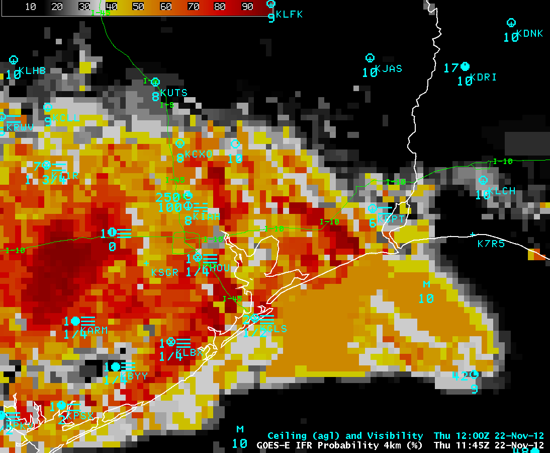 (Click image to enlarge)
Figure caption: GOES-R IFR Probability product (with the algorithm applied to GOES-13 data) showing high probabilities (in the 80-90% range) of IFR conditions along the portion of Interstate 10 in southeastern Texas where a fog-related 140-vehicle accident occurred on the morning of November 22, 2012.
Annual Wall-to-Wall Property Inventory Completed at ASPB: The
annual NESDIS wall-to-wall property inventory, required to be done in
the first quarter of each fiscal year, was completed at the NESDIS
Advanced Satellite Products Branch (ASPB) in Madison, WI, on 19 November
2012. All 83 assets of personal federal property assigned to ASPB were
located, documented, and resolved in Sunflower (the NOAA property
management software system). The resolution results document and
certification forms were uploaded to Sunflower to complete the FY2013
property requirements. (G. S. Wade, E/RA2, 608-263-4743,
gary.s.wade@noaa.gov; J.Key, E/RA2, 608-263-2605, jeff.key@noaa.gov)
VISITORS:
NEXT WEEK:
LOOKING AHEAD:
| Archived Weeklies Page | Submit a report item |