
[ Archive ]

|
ASPB and CIMSS Weekly Report
[ Archive ] |
|
IN THE PRESS:
ITEMS FOR THE ADMINISTRATOR:
ITEMS FOR THE ASSISTANT ADMINISTRATOR:
ITEMS FOR THE OFFICE DIRECTOR, STAR:
Visit to Australian Bureau of Meteorology: Mike Pavolonis (NOAA/NESDIS/STAR) and Corey Calvert (Cooperative Institute for Meteorological Satellite Studies, CIMSS) visited the Australian Bureau of Meteorology (BoM) in Melbourne, Australia, December 2-7, 2012. The purpose of the visit was to continue to collaborate on cloud remote sensing science and software issues. Several mutually beneficial exchanges occurred. Updated versions of the GEOstationary Cloud Algorithm Testbed (GEOCAT) and the Clouds from AVHRR (Advanced Very High Resolution Radiometer) Extended (CLAVR-x) processing systems were installed and tested on BoM computers. The GEOCAT and CLAVR-x software can be used to generate a large suite of STAR products, including the STAR volcanic cloud products, which will be used by the Darwin Volcanic Ash Advisory Center (VAAC). BoM has agreed to provide feedback on these products. In addition, GEOCAT was modified to optionally utilize the BoM regional Numerical Weather Prediction (NWP) model, ACCESS-R (the regional Australian Community Climate and Earth-System Simulator). Accurate NWP fields are needed to produce high quality volcanic cloud products and the high spatial resolution ACCESS-R fields will improve the accuracy of the volcanic cloud products over a large portion of the Pacific and Indian Oceans, where NOAA is partially responsible for issuing volcanic ash advisories. M. Pavolonis also gave seminars on volcanic cloud and fog/low cloud remote sensing. (M. Pavolonis, E/RA2, 608-263-9597, Mike.Pavolonis@noaa.gov; C. Calvert, CIMSS)
Arctic Report Card 2012 Released: The NOAA Arctic Report Card for 2012 is now available at http://www.arctic.noaa.gov/reportcard/. Jeff Key and Yinghui Liu (Cooperative Institute for Meteorological Satellite Studies, CIMSS) are co-authors on the "Temperature and Clouds" section. The Arctic Report Card provides clear, reliable and concise environmental information on the current state of the Arctic relative to historical time records. Prepared under the direction of an inter-agency editorial team, this peer-reviewed, web-based annual update is written by an international team of 141 scientists from 15 countries. “The Arctic is changing in both predictable and unpredictable ways, so we must expect surprises,” said Jane Lubchenco, who participated in a panel discussion that presented the annual update of the Arctic Report Card at the American Geophysical Union meeting in San Francisco. (J. Key, E/RA2, 608-263-2605, jkey@ssec.wisc.edu; Y. Liu, CIMSS, 608-265-8620)
ITEMS FOR THE DIVISION CHIEF, CoRP:
CIMSS VISIT Activities: S. Lindstrom led the Virtual Institute for Satellite Integration Training (VISIT) lesson "Geostationary Operational Environmental Satellite (GOES)-R Fog/low stratus (FLS) products" on December 5, with staff from the National Weather Service forecast office at Buffalo, New York and the Aviation Weather Center in Kansas City, Missouri participating in the training. In addition, the Cooperative Institute for Meteorological Satellite Studies (CIMSS) Satellite Blog was updated with a post containing a variety of satellite images of Super Typhoon Bopha (http://cimss.ssec.wisc.edu/goes/blog/archives/11937), a Category 5 tropical cyclone which was responsible for over 400 fatalities in the Philippines on December 3. (S. Lindstrom, CIMSS, 263-4425, S. Bachmeier, CIMSS, 608-263-3958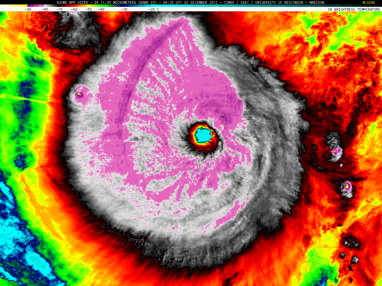 (Click image to enlarge)
VISITORS:
NEXT WEEK:
LOOKING AHEAD:
| Archived Weeklies Page | Submit a report item |