
[ Archive ]

|
ASPB and CIMSS Weekly Report
[ Archive ] |
|
IN THE PRESS:
ITEMS FOR THE ADMINISTRATOR:
ITEMS FOR THE ASSISTANT ADMINISTRATOR:
ITEMS FOR THE OFFICE DIRECTOR, STAR:
Comments on R&D Portfolio Review Task Force Report: The
following summarizes Cooperative Institute for Meteorological Satellite
Studies (CIMSS) feedback to the NOAA Science Advisory Board (SAB) draft
report on NOAA's research and development portfolio, "In the Nation's
Best Interest: Making the Most of NOAA's Science Enterprise". This
report is a very thoughtful review. It puts research and development
directly under the NOAA umbrella. CIMSS has two major comments:
1) The report notes the values of the Cooperative Institutes (CIs) and
NOAA scientists. One of the successful attributes of the CIs is their
ability to help transition current research to operations. This is
particularly affective for those institutes that have NOAA employees
co-located with the institute. Any downsizing of CI should include
consideration the value of having collocated NOAA scientists with the
University staff. As NOAA seeks to reduce its own work force, it should
seek to preserve the scientists stationed at CIs in order to best
maintain the strong collaborations and deliver high returns per dollar
invested in them.
2) Research to operations is an important aspect of NOAA science. It
should be remembered that this transition varies in time. In other
words, some transitions may only take a year, while others many years.
So it is important to remember that not all research can be transitioned
to operations in one year or at the end of a three year project.
Sometimes the path to operations is a bit blurry and more time
consuming. Grants with one or two year time periods do not typically
engage graduate students at the PhD level.
(S. Ackerman, CIMSS, 608-263-3647)
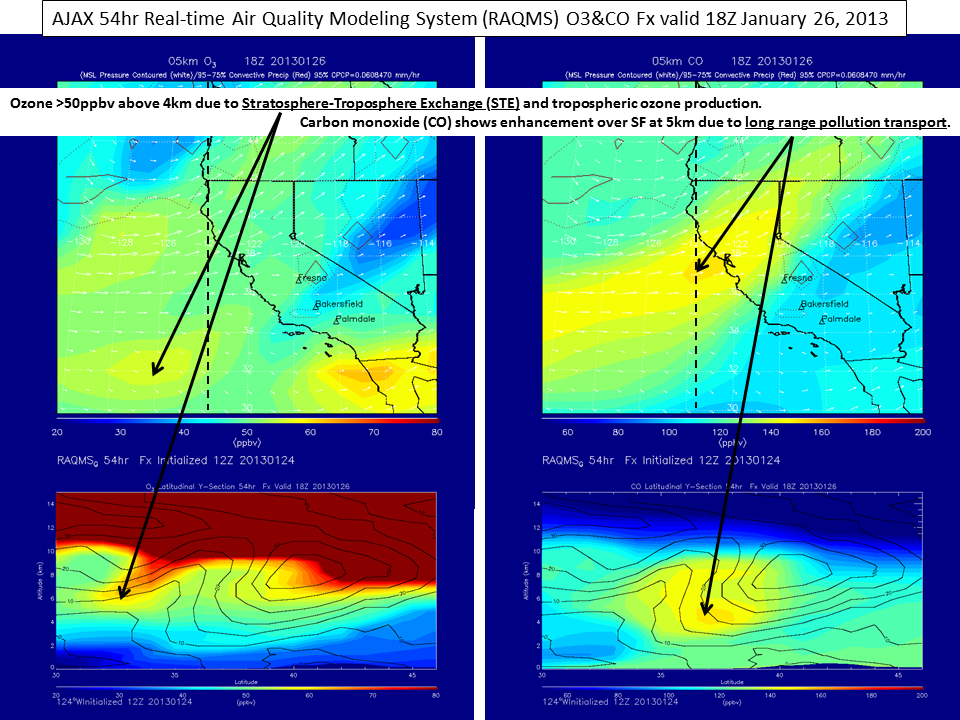
RAQMS Supporting NASA AJAX and DISCOVER-AQ Missions: The
Real-time Air Quality Modeling system (RAQMS) is currently providing
ozone (O3), carbon monoxide (CO), and methane (CH4) forecasts over
California (http://raqms.ssec.wisc.edu/data/forecast/) to support the NASA Ames Research Center Alpha Jet Atmospheric eXperiment (AJAX) field experiment (http://geo.arc.nasa.gov/ajax/ajax_index.html).
AJAX flights are conducting in situ measurements over California to
provide information on free tropospheric background conditions to
support the NASA DISCOVER-AQ (Deriving Information on Surface Conditions
from Column and Vertically Resolved Observations Relevant to Air
Quality) airborne mission. DISCOVER-AQ (http://discover-aq.larc.nasa.gov/)
is a 4 year NASA Earth Venture airborne program to improve the use of
satellites to monitor air quality for public health and environmental
benefit. Through targeted airborne and ground-based observations,
DISCOVER-AQ will enable more effective use of current and future
satellites to diagnose ground level conditions influencing air quality
(R.B. Pierce, E/RA2, 608-890-1892, brad.pierce@noaa.gov, T. Schaack,
SSEC, 608-263-3210, A. Lenzen, SSEC, 608-263-3897)
 (Click image to enlarge)
Figure caption: 54hr RAQMS forecast of 5km O3 (upper left) and CO (upper
right) and O3 (lower left) and CO (lower right) cross-sections at 124W
valid at 18Z January 26, 2013 showing enhanced O3 due to both
Stratosphere-Troposphere Exchange (STE) and tropospheric ozone
production associated with long-range transport of pollution (elevated
CO) from Asia.
ITEMS FOR THE DIVISION CHIEF, CoRP:
IPCC Lead Authors Meeting: Jim Kossin (NCDC/RSAD) attended the 4th Lead Authors Meeting of the IPCC AR5, held in Hobart, Tasmania on 13-18 January. Strategies to address the comments from the open review of the Second Order Draft were defined, and required tasks and deadlines for crafting the Final Draft were established. Kossin is a Lead Author on Chapter 14 (Climate Phenomena and their Relevance for Future Regional Climate Change) and a Contributing Author on Chapter 2 (Observations: Atmosphere and Surface) and Chapter 10 (Detection and Attribution of Climate Change: from Global to Regional). (J. Kossin, NCDC/RSAD, 608-265-5356) (Click image to enlarge)
VISITORS:
NEXT WEEK:
LOOKING AHEAD:
| Archived Weeklies Page | Submit a report item |