
[ Archive ]

|
ASPB and CIMSS Weekly Report
[ Archive ] |
|
IN THE PRESS:
ITEMS FOR THE ADMINISTRATOR:
ITEMS FOR THE ASSISTANT ADMINISTRATOR:
ITEMS FOR THE OFFICE DIRECTOR, STAR:
Bill Line to be Satellite Liaison at the NOAA/National Weather Service Storm Prediction Center (SPC): Bill Line, working with Ralph Petersen, a pioneer in NearCasting, completed his M.S. work at the University of Wisconsin-Madison on the development and improvement of a NearCasting model that makes use of GOES soundings. Nearcasting is the time between nowcasting (0-1 hours) and forecasting (beyond 12 hours). He is heading to Norman, Oklahoma, where he will be the new Cooperative Institute for Mesoscale Meteorological Studies (CIMMS) Satellite Liaison at the NOAA/National Weather Service Storm Prediction Center (SPC). A story about Bill can be found at http://www.ssec.wisc.edu/news/articles/2912. (S. Ackerman, CIMSS, 608-263-3647)
ITEMS FOR THE DIVISION CHIEF, CoRP:
New Pyrocumulonimbus Blog: A new Pyrocumulonimbus (PyroCb) Blog (http://pyrocb.ssec.wisc.edu) was initiated at the Cooperative Institute for Meteorological Satellite Studies (CIMSS). This blog will serve to catalog a set of severe pyroCb events during the upcoming fire season, in an effort to begin an investigation into the effects of heavy aerosol loading (from smoke plumes) on ice clouds. For selected events CIMSS will perform detailed ice cloud retrievals and determine the influence of absorbing aerosols on subsequent ice cloud property retrievals. (B. Baum, CIMSS, 608-263-3898, S. Bachmeier, CIMSS, 608-263-3958)
Manuscript on Air Quality Impacts of California Emissions Submitted: A manuscript entitled “Impact of southern California anthropogenic emissions on ozone pollution in the mountain states” by Min Huang, Kevin W. Bowman, Gregory R. Carmichael, R. Bradley Pierce, Helen M. Worden, Ming Luo, Owen R. Cooper, Ilana B. Pollack, Thomas B. Ryerson, and Steve S. Brown was submitted to the Journal of Geophysical Research-Atmospheres. This manuscript uses the Sulfur Transport and dEposition Model (STEM) nested within the Real-time Air Quality Modeling System (RAQMS) and measurements obtained during the NOAA CalNex field mission to assess the impact of southern California anthropogenic emissions on ozone in the mountain states in May 2010. Case studies show that different scales of transport (e.g., trans-Pacific, stratospheric intrusions and inter-state) can be dynamically and chemically coupled and simultaneously affect O3 in the mountain states when the meteorology conditions are favorable (R.B. Pierce, E/RA2, 608-890-1892, brad.pierce@noaa.gov)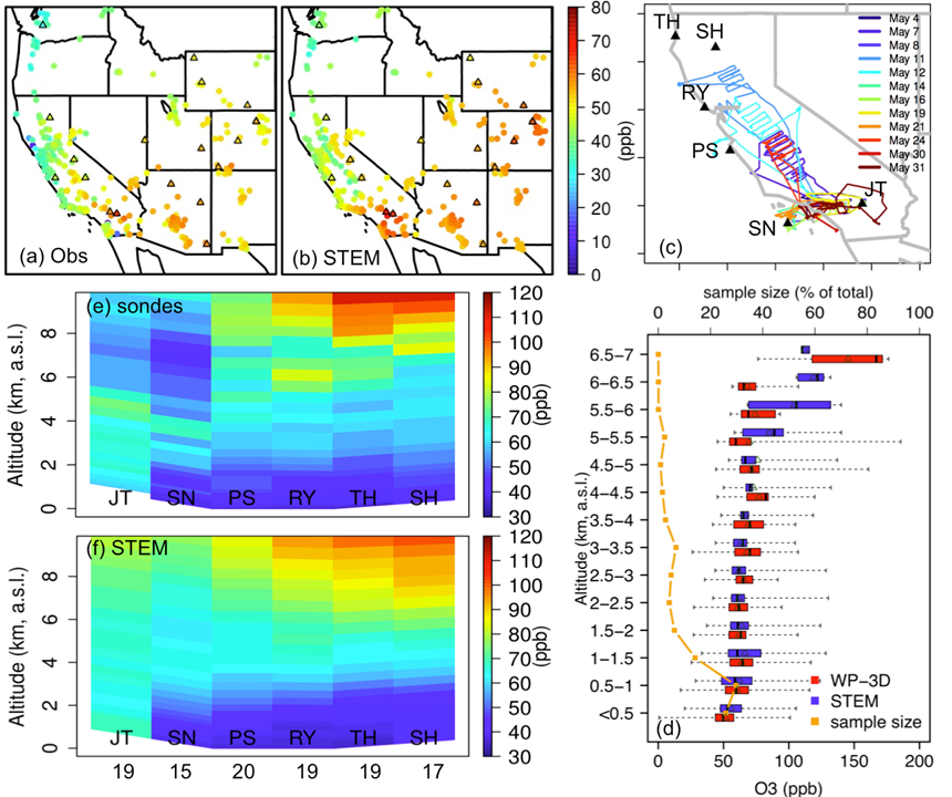 (Click image to enlarge)
 (Click image to enlarge)
VISITORS:
NEXT WEEK:
LOOKING AHEAD:
| Archived Weeklies Page | Submit a report item |