
[ Archive ]

|
ASPB and CIMSS Weekly Report
[ Archive ] |
|
IN THE PRESS:
ITEMS FOR THE ADMINISTRATOR:
ITEMS FOR THE ASSISTANT ADMINISTRATOR:
ITEMS FOR THE OFFICE DIRECTOR, STAR:
RAQMS supports Wyoming Exceptional Event Demonstration: On
May 21, 2013, the State of Wyoming Department of Environmental
Quality/Air Quality Division released a document entitled “Exceptional
Event Demonstration Package for the Environmental Protection Agency
Thunder Basin, Wyoming Ozone Standard Exceedance June 6, 2012”
(http://deq.state.wy.us/aqd/Exceptional%20Events/June_6_2012ThunderBasin/June_6_2012_SI_Package.pdf)
for public comment. In the exceptional event demonstration, results
from Real-time Air Quality Modeling System (RAQMS) ozone analyses and
Lagrangian trajectory analysis were used determine the genesis of a
stratospheric intrusion (SI) event observed by the NASA Ames Alpha Jet
Atmospheric eXperiment (AJAX,
http://geo.arc.nasa.gov/ajax/ajax_index.html) over California on June 5,
2012 that led to surface ozone exceedances on June 6, 2012 at the
Thunder Basin ozone monitor in NE Wyoming. Following the public comment
period, this document will be submitted to the US Environmental
Protection Agency (US EPA) to demonstrate that the surface ozone
exceedances where due to an exceptional event associated with a
stratospheric intrusion (SI). According to the US EPA, exceptional
events are unusual or naturally occurring events that can affect air
quality but are not reasonably controllable using techniques that
tribal, state or local air agencies may implement in order to attain and
maintain the National Ambient Air Quality Standards.
(R.B. Pierce, E/RA2, 608-890-1892, brad.pierce@ssec.wisc.edu)
 (Click image to enlarge)
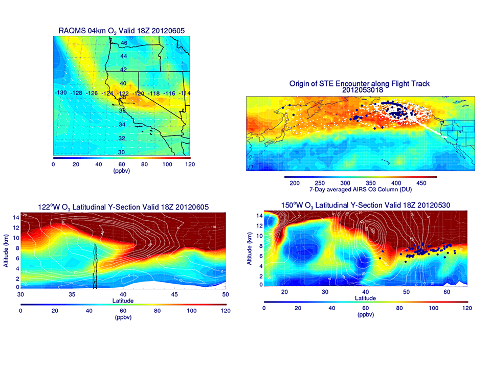
Figure caption: RAQMS 4km ozone (O3, ppbv, upper left panel) map and
122W cross-section (ppbv, lower left panel) on 5 June 2012 at 11 am MST.
The AJAX flight track is shown in black. Note the tropopause fold
indicated by the tongue of high ozone extending from the lower
stratosphere into the mid-troposphere. Upper right panel shows a map of
7-day averaged (May 30-June 5, 2012) AIRS total column O3 (DU) with back
trajectory history (white) and origin (white with blue edges) at 11 am
MST on May 30, 2012 for AJAX Flight 47 SI encounter. Lower right panel
shows RAQMS 150W O3 (ppbv) and zonal wind (m/s) cross-section with
origin of AJAX Flight 47 SI encounter (blue dots) at 11 am MST on May
30, 2012.
CSPP/IMAPP User's Group Meeting, Madison WI:
The first Community Satellite Processing Package (CSPP) and
International MODIS/AIRS Processing Package (IMAPP) Users’ Group Meeting
was held in Madison, Wisconsin, 21-23 May 2013. The goal of the
meeting was to bring together the worldwide community of CSPP and IMAPP
users to discuss issues relevant to reception, processing, and
applications of data acquired by direct broadcast from the Suomi NPP,
Terra, and Aqua satellites. Bob Aune gave a presentation on improvements
to the IMAPP Direct Broadcast CIMSS Regional Assimilation System
(DBCRAS). Andy Heidinger and Nick Bearson briefed on the CSPP
implementation of the
NESDIS Clouds from AVHRR Extended (CLAVR-x) processing system. Many
other Cooperative Institute for Meteorological Satellite Studies
(CIMSS), Space Science and Engineering Center (SSEC), and NOAA personnel
participated, along with attendees from Sweden, UK, France, Germany,
Mexico, and Australia. CSPP is supported by the JPSS program. (R. Aune,
E/RA2, 608-262-1071; A. Heidinger, E/RA2, 608-263-6757,
andrew.heidinger@noaa.gov, Nick Bearson, CIMSS,
nick.bearson@ssec.wisc.edu)
Third Meeting of the Polar Space Task Group: The third meeting of the World Meteorological Organization's (WMO) Polar Space Task Group (PSTG) was held at Centre National d’Etudes Spatiales (CNES) in Paris, France, 22-23 May 2013. The PSTG was established for the purpose of space agency planning, processing, and archiving of satellite products covering, or relevant to, the polar regions. All major space agencies have representatives on the PSTG. Jeff Key, PSTG Vice Chair, participated remotely due NOAA travel cuts. (J. Key, E/RA2, 608-263-2605, jkey@ssec.wisc.edu)
ITEMS FOR THE DIVISION CHIEF, CoRP:
 (Click image to enlarge)
Figure caption: 1-km resolution MODIS 0.65 µm visible channel visible
and 11.0 µm InfraRed (IR) images at 19:36 UTC (about a half hour before
the tornado moved through Moore, Oklahoma) displayed signatures of
vigorous convective overshooting tops, with cloud-top IR brightness
temperatures as cold as -76º C.
 (Click image to enlarge)
VISITORS:
NEXT WEEK:
LOOKING AHEAD:
| Archived Weeklies Page | Submit a report item |