 |
ASPB and CIMSS Weekly Report
[ Archive ] |
 |
ASPB AND CIMSS WEEKLY HIGHLIGHTS FOR THE WEEK ENDING JUNE 8, 2013
IN THE PRESS:
ITEMS FOR THE ADMINISTRATOR:
ITEMS FOR THE ASSISTANT ADMINISTRATOR:
ITEMS FOR THE OFFICE DIRECTOR, STAR:
MTG Infrared Radiation Sounder Science Team Meeting: On
30-31 May 2013, Paul Menzel attended the Meteosat Third Generation
(MTG) Infrared Radiation Sounder (IRS) Science Team (MIST) meeting in
Rome, Italy. Items of note include (1) MTG-Imager launch is now
scheduled for 4Q-2018 and MTG-Sounder will follow two years later; (2)
MTG-IRS Algorithm Theoretical Basis Document (ATBD) V2.0 is available and issues still requiring attention
include specification of the apodization, processing at large viewing
angles, accommodating the large Jacobians, developing a strategy for
observed minus forward model calculated bias correction, adjusting model
surface emissivity (suggestion is to retrieve ln[es/(1-es)] for IRS
measurements). Data dissemination to users will select 150 spectral
samples per band out of 1000 available. On 26-27 July,
he and Herve Roquet from MeteoFrance are co-chairing an IRS-Nowcasting
workshop to be held in Darmstadt, Germany. (W.P. Menzel, CIMSS,
608-263-4930)
ITEMS FOR THE DIVISION CHIEF, CoRP:
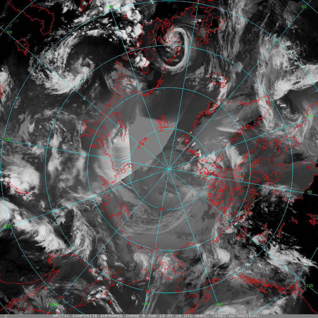
Polar Satellite Composite Imagery and LEO/GEO Atmospheric Motion Vectors Satellite Training Presentation: On Wednesday June 5th, as a part of a satellite training teleconference series for the National Weather Service Alaska Region (NWS AR), a presentation was given on Arctic/Antarctic satellite composite imagery and 'LEO/GEO' (Low-Earth Orbit/Geostationary Orbit) atmospheric motion vectors (AMV) projects in progress at the Cooperative Institute for Meteorological Satellite Studies (CIMSS). The Arctic satellite composite imagery effort, demonstrated during the International Polar Year with support from the National Science Foundation, is a Product System Development and Implementation (PSDI) project with the Office of Systems Development (OSD). The 'LEO/GEO' AMV effort is a related project that stems from a Geostationary Operational Environmental Satellite (GOES)-R Risk Reduction project that demonstrated the capability of deriving AMVs using Arctic/Antarctic satellite composites in a gap region between polar-orbiting AMVs and geostationary AMVs. (M. Lazzara, AMRC/SSEC-CIMSS, 608-262-0436)
 (Click image to enlarge)
Figure caption: An infrared window (11.0 micron) Arctic composite satellite image from 16 UTC on 5 June 2013 is created from a combination of geostationary and polar-orbiting satellite observations.
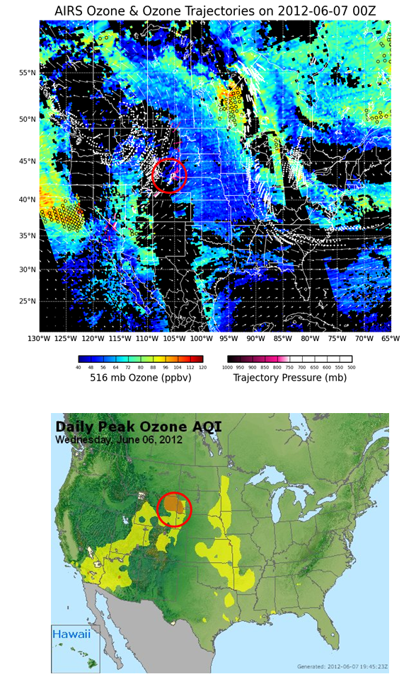
NASA Air Quality Applied Science Team Meeting: Brad Pierce remotely presented a talk entitled “Implementation of AIRS, IASI, and CrIS based stratospheric intrusion forecasting capability into IDEA-International” at the 5th biannual NASA Air Quality Applied Science Team (AQAST) meeting in College Park, MD (http://acmg.seas.harvard.edu/aqast/meetings/2013_jun/index.html). AQAST meetings bring team members, air quality managers, and research and applications partners together to develop better ways of serving air quality management needs through the use of Earth Science data and tools. The AQAST presentation provided a summary of the status of development of a real-time, satellite based forecasting tool support to state and local air quality management for stratospheric intrusion (SI) related exceptional event analysis. The Infusing Satellite Data Into Environmental Applications - International (IDEA-I) SI forecast is being developed within the Community Satellite Processing Package (CSPP), which supports the Direct Broadcast (DB) satellite community through the packaging and distribution of open source science software. IDEA-I SI forecast capability is currently being beta tested during a June 6, 2012 Wyoming SI exceptional event period at the Cooperative Institute for Meteorological Satellite Studies (CIMSS) using the UW-Madison Dual Regression retrieval (R.B. Pierce, E/RA2, 608-890-1892, brad.pierce@noaa.gov, J. Davies, K. Strabala, E. Weisz, N. Smith, B. Cintineo, SSEC)
 (Click image to enlarge)
Figure caption: The upper panel shows a 48 hour IDEA-I SI trajectory forecast valid at 00Z on June 07, 2012. The initial locations of the trajectories are determined based on the AIRS ozone and dewpoint depression retrievals and are indicated by the open circles. The pressures of the trajectories are indicated by the red-white color table where red indicates higher pressures. The lower panel shows the U.S. Environmental Protection Agency (EPA) surface Air Quality Index (AQI) on June 6, 2012. Orange indicates that the ozone has reached levels which are considered “Unhealthy for Sensitive Groups” (http://www.airnow.gov/?action=aqibasics.aqi). The IDEA-I SI trajectory forecast shows that high surface ozone over Wyoming on June 06, 2012 were caused by elevated mid-tropospheric ozone values associated with a SI event that was observed by the Atmospheric InfraRed Sounder (AIRS) on June 04, 2012 off the coast of California. This elevated ozone was transported eastward over Wyoming and descended below 800mb.
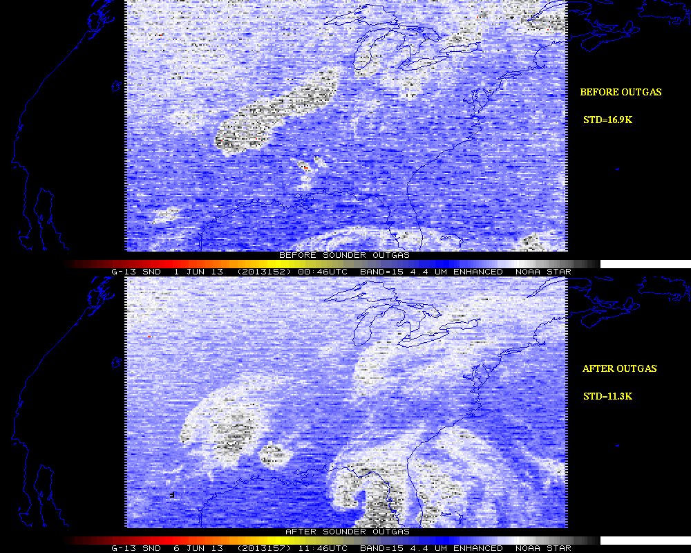
Test GOES-13 Sounder Science Support: The Space Science and Engineering Center (SSEC) Data Center acquired test Geostationary Operational Environmental Satellite (GOES)-13 Sounder data beginning again 6 June 2013 (as part of the recovery process following the satellite anomaly of 22 May 2013). These images were after the 4-day GOES Sounder outgas (e.g., heating). Multi-band images (as well as those from GOES-14 Sounder for comparison) were sent to the Office of Satellite Products and Operations (OSPO) and others. Overall, the image quality in band 15 was improved. More information on GOES-13 is at http://cimss.ssec.wisc.edu/goes/blog/archives/13145 and http://cimss.ssec.wisc.edu/goes/rt/sounder-dpi.php. Current plans call for GOES-13 to return to operations on 10 June 2013, unless it is a critical weather day. (T. Schmit, E/RA2, 608-263-0291, tim.j.schmit@noaa.gov; J. Nelson, CIMSS, 608-263-6013, jim.nelson@ssec.wisc.edu; T. Schreiner, CIMSS, 608-263-6754, tony.schreiner@ssec.wisc.edu; M. Gunshor, CIMSS, 608-263-1146, mat.gunshor@ssec.wisc.edu; J. Robaidek, SSEC, 608-262-6025, jerrold.robaidek@ssec.wisc.edu)
 (Click image to enlarge)
Figure caption: GOES-13 4.4 µm Sounder from before (top) and after (bottom) outgassing. Standard deviation of brightness temperatures are listed on the right-hand side.
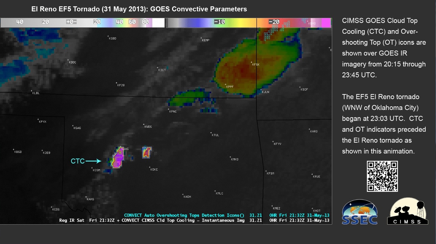
Continuation of CIMSS/SSEC Imagery at NOAA College Park: Science activities at the Cooperative Institute for Meteorological Satellite Studies (CIMSS) at the University of Wisconsin-Madison Space Science and Engineering Center (SSEC) continue to be promoted by the provision of recent research imagery for display on the lobby monitors of the National Center for Weather and Climate Prediction (NCWCP) in College Park, MD. The last two weeks emphasized prototype products developed at CIMSS for the future Geostationary Operational Environmental Satellite (GOES)-R, which were being evaluated as part of the GOES-R Proving Ground participation in the Hazardous Weather Testbed in Norman, OK in May 2013. The example animations provided, of GOES Sounder Nearcasting (from 20 May 2013) as well as the GOES Cloud Top Cooling (CTC) and Overshooting Top (OT) products (from 31 May 2013), are available at (1) http://www.ssec.wisc.edu/noaa-display/wk20130520/cimss2ncwcp-moore_tornado.gif and
(2) http://www.ssec.wisc.edu/noaa-display/wk20130603/CIMSS-CTC-OT-ovr-OK-20130531-20-23z-anim.gif. The displays must be modified to fit the wide (1920x1080) monitor format, need to tell a story in only 10 seconds, and include a QR (Quick Response) matrix barcode to link the viewer to more information from the appropriate CIMSS Satellite Blog post (if available). (B. Bellon, CIMSS, 608-263-6726, bill.bellon@ssec.wisc.edu; S. Bachmeier, CIMSS, 608-263-3958, scott.bachmeier@ssec.wisc.edu; G.S. Wade, E/RA12, 608-263-4743, gary.s.wade@noaa.gov)
 (Click image to enlarge)
Figure caption: Single image (at 2132 UTC) from the animation of the CIMSS Cloud Top Cooling (CTC) product overlaid on the GOES longwave window infrared imagery on 31 May 2013 (before the El Reno, OK tornado).
JCSDA 11th Workshop on Satellite Data Assimilation: T. Greenwald, Jinlong Li, J. Jung, and D. Santek were invited to present at the 11th Joint Center for Satellite Data Assimilation (JCSDA) Workshop on Satellite Data Assimilation in College Park, MD. Presentations were given describing current efforts in tropical cyclone forecasts, improvements to the CRTM, effects of supersaturation in the global model, and the impact of polar atmospheric motion vectors on forecasts. The workshop was held from 5-7 June 2013. (D. Santek, CIMSS, 608-263-7410)
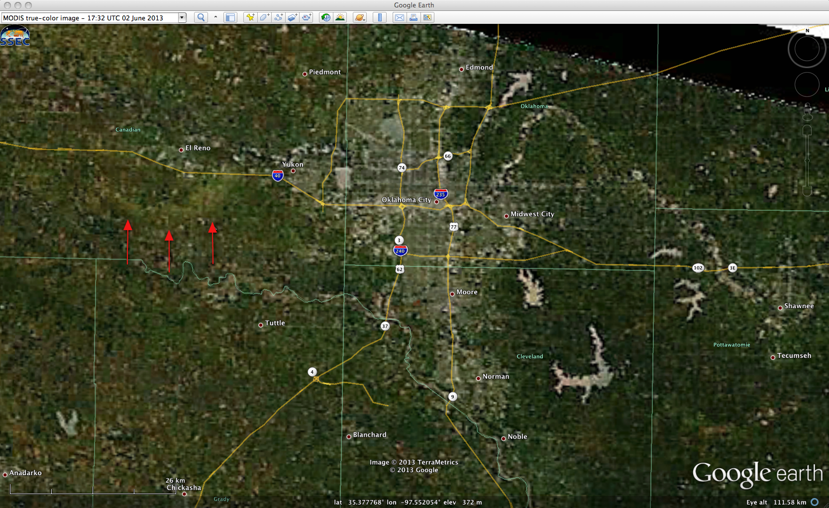
CIMSS VISIT Activities: The Virtual Institute for Satellite Integration Training (VISIT) lesson "Visible Infrared Imager Radiometer Suite (VIIRS) Satellite Imagery in Advanced Weather Interactive Processing System (AWIPS)" was updated with examples of using VIIRS imagery to diagnose ice jam flooding in Alaska. In addition, the Cooperative Institute for Meteorological Satellite Studies (CIMSS) Satellite Blog (http://cimss.ssec.wisc.edu/goes/blog/) was updated with new posts on Tropical Storm Andrea, updates on the status of Geostationary Operational Environmental Satellite (GOES)-13, and Severe weather in the Oklahoma City area (which included imagery showing the damage scar from the EF5 El Reno tornado). (S. Bachmeier, CIMSS, 608-263-3958)
 (Click image to enlarge)
Figure caption: MODIS true-color image (displayed using Google Earth) showing the damage scar from the 2.6-mile-wide EF5 El Reno, Oklahoma tornado.
VISITORS:
CIRA's Kathy Fryer Visits ASPB: On the afternoon
of 28 May 2013, Kathy Fryer from the Cooperative Institute for Research
in the Atmosphere (CIRA) in Fort Collins, CO visited the Cooperative
Institute for Meteorological Satellite Studies (CIMSS) in Madison, WI.
Fryer, who is an administrative associate for the NOAA Regional And
Mesoscale Meteorology Branch (RAMMB), met with several members of the
NOAA Advanced Satellite Products Branch (ASPB) as well as some CIMSS
staff, during a tour of the University of Wisconsin-Madison Space
Science and Engineering Center (SSEC), within which ASPB is
stationed. The opportunity for Fryer to help with some administrative
tasks for the ASPB, especially with regards to travel arrangements
within the NOAA Cooperative Research Program (CoRP), in collaboration
with the CIMSS administrative associate, Maria Vasys, is to be further
explored. (G.S. Wade, E/RA2, 608-263-4743, gary.s.wade@noaa.gov; K.
Fryer, CIRA, 970-491-8446, kathy.fryer@noaa.gov)
NEXT WEEK:
LOOKING AHEAD: