
[ Archive ]

|
ASPB and CIMSS Weekly Report
[ Archive ] |
|
IN THE PRESS:
ITEMS FOR THE ADMINISTRATOR:
ITEMS FOR THE ASSISTANT ADMINISTRATOR:
ITEMS FOR THE OFFICE DIRECTOR, STAR:
Advanced Dvorak Technique - Version 8.1.4 Operational at NOAA/SAB: The
Advanced Dvorak Technique (ADT) algorithm, developed by scientists at the Cooperative Institute for Meteorological Satellite Studies (CIMSS), has been implemented operationally at NOAA/Satellite Analysis
Branch on July 10, 2013. The ADT produces estimates of tropical cyclone
(TC) intensity using geostationary infrared window (IRW) channel
imagery. Several major upgrades mark the 8.1.4 version of the ADT,
including the direct use of passive microwave (PMW) imagery to derive an
"eye score", which aids the intensity estimation process when an eye
feature is not present in the IRW imagery, and the implementation of the
Courntey/Knaff/Zehr methodology for deriving a mean sea level pressure
(MSLP) value from the ADT intensity estimate. Several addition
modifications to the internal regression equations, relating several
satellite-measured parameters to the current intensity estimate, and
intensity constraint rules were also implemented. (T. Olander, CIMSS,
608-265-8005, C. Velden, CIMSS, 608-262-9168)
Western Air Quality Modeling Workshop -Technical Methods and Applications:
Brad Pierce gave an invited talk entitled “Satellite based support for
stratospheric intrusion special event analysis” at the 2013 Western Air
Quality Modeling Workshop – Technical Methods and Applications, July
9-11, 2013 Boulder, CO. This talk presented an introduction to the
Infusing Satellite Data Into Environmental Applications - International
(IDEA-I) stratospheric intrusion forecast that is being developed under
the NOAA Community Satellite Processing Package (CSPP). The Western Air
Quality Modeling Workshop was sponsored by the Western Regional Air
Partnership (WRAP), US Environmental Protection Agency (EPA) Region 8
and EPA Office of Air Quality Planning and Standards (OAQPS).
Participation in this workshop is by invitation only and was designed
for state, tribal, federal, and local air agency staff. (R.B. Pierce,
E/RA2, 608-890-1892, brad.pierce@noaa.gov)
ITEMS FOR THE DIVISION CHIEF, CoRP:
North Carolina Museum Presentation and ESIP Teacher Workshop: The fifth Earth Science and Information Partners (ESIP) Teacher Workshop took place on Tuesday July 9, 2013 on the University of North Carolina Chapel Hill campus. Although the workshop was scaled back due to limited funding, the experience earned high ratings by the 14 regional teachers who came to learn about climate change and NOAA and NASA educational resources. The ESIP meeting moved to the North Carolina Museum of Natural Sciences on Wednesday July 10 where several ESIP members presented Ted-style talks in a huge high resolution theater called the Daily Planet. Margaret Mooney from the Cooperative Institute for Meteorological Satellite Studies (CIMSS) made a presentation entitled “Using Satellites to Track and Share Weather and Climate Information” showing several stunning animations from the CIMSS Satellite Blog. Featured animations progressed from 15-minute operational displays to rapid scan (5-minute) and super rapid scan (1-minute) imagery. This provided the opportunity to explain advantages of the GOES-R satellite. The presentation also included several day-night band images from the Suomi NPP satellite before ending with a Climate Digest video from the CIMSS EarthNow Blog. (M. Mooney, CIMSS, 608-265-2123, S. Bachmeier, CIMSS, 608-263-3958, P. Rowley, 608-263-1336)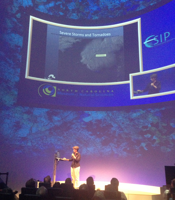 (Click image to enlarge)
 (Click image to enlarge)
VISITORS:
NEXT WEEK:
LOOKING AHEAD:
| Archived Weeklies Page | Submit a report item |