
[ Archive ]

|
ASPB and CIMSS Weekly Report
[ Archive ] |
|
IN THE PRESS:
ITEMS FOR THE ADMINISTRATOR:
ITEMS FOR THE ASSISTANT ADMINISTRATOR:
ITEMS FOR THE OFFICE DIRECTOR, STAR:
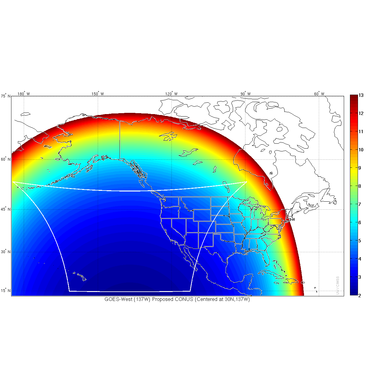
GOES-R CONUS Sector Shift: Researchers at the Cooperative Institute for Meteorological Satellite Studies (CIMSS) generated images displaying various scan scenarios for the Advanced Baseline Imager (ABI) on Geostationary Operational Environmental Satellite (GOES)-R to advise the National Weather Service (NWS) Operational Advisory Team (NOAT) on the current scan scenario outlined in the Product definition and User's Guide (PUG) Volume 5A: Level 2+ Products. The scan sectors under Mode 3 (or "flex mode") currently planned for the CONtinental United States (CONUS) are different for GOES-R from what is scanned for current GOES and subsequently delivered to NWS. Of particular concern is the plan to use GOES-West to scan a CONUS sector that will include the entire Continental U.S. despite poor view angles of New England, instead of scanning what is referred to now as the PACific United States (PACUS) sector that includes Hawaii and the areas over the Pacific Ocean from which the U.S. West Coast receives the majority of their weather. This situation was brought to the attention of the NOAT and other interested parties in the NWS and a scan scenario more similar to today's strategy was provided for feedback, maintaining the requirement of a sector that is 2500 pixels wide by 1500 pixels high. (M. Gunshor, CIMSS, 608-263-1146, T. Schmit, E/RA2, 608-263-0291, J. Gerth, CIMSS, 608-263-4942)
 (Click image to enlarge)
Figure caption: Proposed GOES-West (centered at 137 West Latitude) Advanced Baseline Imager (ABI) "CONUS" scan (outlined in white) that has been shifted significantly to the west to capture Hawaii and maximize the coverage with better view angles. The colors depicted in the scene represent approximate pixel sizes for a nominally 2-kilometer (km) resolution infrared band. Note that the pixel sizes reach 13 km and greater at the farthest extents into New England.
Manuscript on the Impact of Terrain Altitude and Cloud Height on Ozone Remote Sensing Published: A manuscript entitled "Impact of Terrain Altitude and Cloud Height on Ozone Remote Sensing from Satellite" has been published in the Journal of Atmospheric and Oceanic Technology (Vol. 31, P.903 – 912). This collaborative study indicates that, with satellite-based infrared (IR) ozone remote sensing, high terrain and cloud presence will reduce ozone sensitivity and information content. For ultraviolet (UV) bands, the effect is spectrally dependent: lower terrain altitude and the presence of clouds will increase the zone information content in the longer UV band, but they have no effect in the short UV band. The co-authors are W. Bai, C. Wu (China Meteorological Administration, CMA), Jun Li (Cooperative Institute for Meteorological Satellite Studies, CIMSS), and W. Wang (CMA). (Jun Li, 608-262-3755, Jun.Li@ssec.wisc.edu)
Paper Published on AIRS Radiance Assimilation: A paper was published in the Journal of Applied Remote Sensing on regional assimilation of clear sky Atmospheric Infrared Sounder (AIRS) radiances in short-term weather forecasting using the community Gridpoint Statistical Interpolation and Weather Forecasting and Research models. The citation is Agnes H. N. Lim, James A. Jung, Hung-Lung Allen Huang, Steven A. Ackerman and Jason A. Otkin, 2014, Assimilation of clear sky Atmospheric Infrared Sounder radiances in short-term regional forecasts using community models", J. Appl. Remote Sens. 8(1), 083655, http://dx.doi.org/10.1117/1.JRS.8.083655. (A. Lim, CIMSS)
ITEMS FOR THE DIVISION CHIEF, CoRP:
VISIT Training on Forecasting Intercontinental Pollution Transport: Brad Pierce presented a Virtual Institute for Satellite Integration Training (VISIT) Satellite Chat entitled “Advances in Real-time Assimilation of Satellite Trace Gas and Aerosol Retrievals for Air Quality Forecasting”. The lecture focused on real-time predictions of the impacts of intercontinental pollution transport and stratosphere/tropospheric exchange processes on regional scale air quality using nested Real-time Air Quality Modeling System (RAQMS) and Rapid Refresh (RAP) with Chemistry air quality forecasts. This work is being done in collaboration with researchers at the NOAA Earth System Research Laboratory (ESRL)(R.B. Pierce, E/RA2, 608-890-1892, brad.pierce@noaa.gov, S. Lindstrom, S. Bachmeier, CIMSS)VISITORS:
Brian Mapes Visit: Brian Mapes of Rosenstiel School of Marine and Atmospheric Sciences (RSMAS) visited the Atmospheric and Oceanic Sciences department and gave a presentation titled "Visualization of the Weather-Climate Connection." Cooperative Institute for Meteorological Satellite Studies (CIMSS) scientist Joleen Feltz, met with Dr. Mapes to discuss the use of McIDAS-V for visualization and data analysis at CIMSS as well as to foster communication between the Integrated Data viewer (IDV) and McIDAS-V user communities. (J. Feltz, CIMSS, 608-263-3434)
NEXT WEEK:
LOOKING AHEAD:
| Archived Weeklies Page | Submit a report item |