
[ Archive ]

|
ASPB and CIMSS Weekly Report
[ Archive ] |
|
IN THE PRESS:
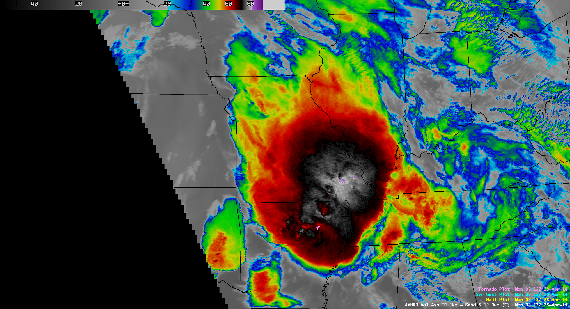
CIMSS Satellite Image Featured in NBC News Story: A Polar Operational Environmental Satellite (POES) Advanced Very High Resolution Radiometer (AVHRR) InfraRed (IR) image was featured in a NBC News web page story about the deadly outbreak of tornadoes in the central and southern United States on April 27, 2014 (http://www.nbcnews.com/storyline/deadly-tornado-outbreak/tornado-storm-system-captured-weather-satellites-n91251). The AVHRR image showed cloud-top IR brightness temperatures as cold as -82ºC, as well as storm-top gravity waves that were propagating northwestward away from the region of vigorous thunderstorm overshooting tops.
 (Click image to enlarge)
Figure caption: POES AVHRR 12.0 µm IR image of the large mesoscale convective system that was responsible for producing deadly tornadoes in Arkansas several hours earlier.
ITEMS FOR THE ADMINISTRATOR:
ITEMS FOR THE ASSISTANT ADMINISTRATOR:
ITEMS FOR THE OFFICE DIRECTOR, STAR:
ITEMS FOR THE DIVISION CHIEF, CoRP:
NASA/NOAA Global Hawk Hurricane Science Meeting: The Hurricane and Severe Storm Sentinel (HS3) science team met this week to review progress from the 2013 field campaign, and to look ahead to the 2014 field campaign. This year, NOAA will support an extra week or so of Global Hawk missions. The goals of overflying hurricanes and observing inner core structure depend highly on satellite data and products for hazard avoidance. This was one of the primary topics of the meeting. The Cooperative Institute for Meteorological Satellite Studies (CIMSS) is supporting the project with tailored real-time satellite imagery and derived products, which are being relied upon by mission scientists and Global Hawk directors. The most important of these are the cloud height estimates based on Andy Heidinger's (STAR) latest GOES-R algorithm, the Tropical Overshooting Tops (TOT) algorithm tailored by Sarah Monette (CIMSS) and based on Kris Bedka's (NASA) algorithm, and atmospheric motion vector (AMV) products. The science team is also utilizing these data in post-analyses and validation studies. (C. Velden, CIMSS, 608-262-9168) (Click image to enlarge)
VISITORS:
NEXT WEEK:
LOOKING AHEAD:
| Archived Weeklies Page | Submit a report item |