
[ Archive ]

|
ASPB and CIMSS Weekly Report
[ Archive ] |
|
IN THE PRESS:
ITEMS FOR THE ADMINISTRATOR:
ITEMS FOR THE ASSISTANT ADMINISTRATOR:
ITEMS FOR THE OFFICE DIRECTOR, STAR:
PhD Research Successfully Defended: Michael Pavolonis (NOAA/NESDIS/STAR) successfully defended his PhD research at the University of Wisconsin – Madison on May 6, 2014. The title of the research dissertation is ”Development of Satellite Remote Sensing Techniques for Quantifying Volcanic Ash Cloud Properties.” The research is being used to improve the timeliness and accuracy of volcanic ash advisories and forecasts issued by Volcanic Ash Advisory Centers (VAACs). (M. Pavolonis, E/RA2, 608-263-9597, Mike.Pavolonis@noaa.gov)
GOES-14 Super Rapid Scan Operations for GOES-R Scanning : The Geostationary Operational Environmental Satellite (GOES)-14 Imager is observing special 1-minute (SRSOR – Super Rapid Scan Operations for GOES-R) data. The dates are to be May 8-22 and August 14-28 2014, which allow special data set collections for GOES-R algorithm developers, research partners, forecasters, and Proving Ground participants. In fact, the experimental rapid-scan imagery has been shown in a number of national centers / test beds. Details (daily image center points, start times, animations and links) are available at http://cimss.ssec.wisc.edu/goes/srsor2014/GOES-14_SRSOR.html. Also see the CIMSS Satellite Blog: http://cimss.ssec.wisc.edu/goes/blog/archives/15582. (T. Schmit, E/RA2, 608-263-0291, tim.j.schmit@noaa.gov)
GOES-R Data Simulator at CIMSS: A GOES-R Rebroadcast (GRB) Simulator was delivered on loan to the Data Center at the Cooperative Institute for Meteorological Satellite Studies/Space Science and Engineering Center (CIMSS/SSEC) on 29 April 2014. Training for the setup and use of the simulator was provided by Ed Czopkiewicz from Harris IT Services on 6-7 May 2014. SSEC will be testing the ingest and processing of the GOES-R data and products from the simulator until the end of July 2014 when it will be returned to Harris Corporation. (D. Santek, CIMSS/SSEC, 608-263-7410, J. Robaidek, SSEC, 608-262-6025, jerrold.robaidek@ssec.wisc.edu)
CIMSS Tests N-Wave Route to Honolulu: On 8 May 2014, Jordan Gerth, a scientist with the Cooperative Institute for Meteorological Satellite Studies (CIMSS), Eric Lau, a meteorologist with the National Weather Service (NWS) Pacific Region Headquarters (PRH), and Ian Chun, a information technology specialist with the NOAA Office of the Chief Information Officer (OCIO), conducted the first end-to-end test of a network route on N-Wave, NOAA's science network, between CIMSS and PRH. The fiber optic network route extends N-Wave from Seattle to Honolulu, and costs NOAA in excess of $50,000 per year to operate. Satellite imagery and products exchanged between CIMSS and PRH will be the first significant use of the N-Wave route between Seattle and Honolulu. CIMSS interfaces with N-Wave via Internet2, assuring timely data delivery for science and research to operations projects involving NOAA's current and future satellite missions. (J. Gerth, CIMSS, 608-263-4942)
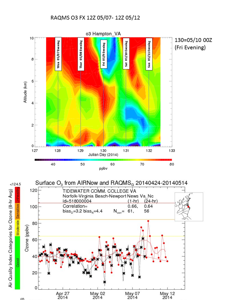
RAQMS O3/CO forecasts for TOLNet LIDAR Intercomparison: Advanced Satellite Products Branch (ASPB) and Space Science and Engineering (SSEC) scientists provided daily ozone (O3) forecasts from the Real-time Air Quality Modeling System (RAQMS) during May 1-9, 2014 to support the NASA sponsored Tropospheric Ozone Lidar Network (TOLNet,http://www-air.larc.nasa.gov/missions/TOLNet/) measurement intercomparison conducted at NASA Langley Research Center in Hampton, VA. On of the main objectives of TOLNet is to foster use of high-resolution ozone and aerosol observations to improve the processes in air-quality forecast models. (R.B. Pierce, E/RA2, 608-890-1892, brad.pierce@noaa.gov)
 (Click image to enlarge)
Figure caption: Altitude (km) time (Julian Day) cross section of RAQMS ozone (ppbv) analysis and forecast for Hampton, VA from Wednesday, May 7th through Sunday May 11, 2014 (upper panel) and comparison between US EPA surface ozone (black) and RAQMS predictions (red) (lower panel)
ITEMS FOR THE DIVISION CHIEF, CoRP:
NOAA/CIMSS ProbSevere Model At NOAA Hazardous Weather Testbed: The Big Spring Experiment at the Hazardous Weather Testbed (HWT) in Norman, Oklahoma began Monday, May 5, 2014. The Experimental Warning Program pairs National Weather Service (NWS) forecasters with researchers and product developers to support the research-to-operations and operations-to-research activities within the Geostationary Operational Environmental Satellite (GOES)-R Proving Ground. The NWS forecasters are evaluating many new products geared toward improving thunderstorm forecasts and severe weather warnings. J. Sieglaff (Cooperative Institute for Meteorological Satellite Studies, CIMSS) is supporting the NOAA/CIMSS Probability of Severe (ProbSevere) Model this week, which is designed to give NWS forecasters more confidence to more accurately issue severe weather warnings earlier than possible without the ProbSevere data. In addition to using the ProbSevere model and evaluating the model performance, the NWS forecasters offer feedback on ways to improve the model and the display they interact with. The GOES-R HWT blog highlights many cases during the experiment, as well as the interactions between NWS forecasters and researchers (http://goesrhwt.blogspot.com/). (J. Sieglaff, CIMSS, 608-265-5357) (Click image to enlarge)
 (Click image to enlarge)
 (Click image to enlarge)
VISITORS:
NEXT WEEK:
LOOKING AHEAD:
| Archived Weeklies Page | Submit a report item |