
[ Archive ]

|
ASPB and CIMSS Weekly Report
[ Archive ] |
|
IN THE PRESS:
ITEMS FOR THE ADMINISTRATOR:
ITEMS FOR THE ASSISTANT ADMINISTRATOR:
August GOES-14 Super Rapid Scan Operations for GOES-R Scanning: The Geostationary Operational Environmental Satellite (GOES)-14 Imager special 1-minute (SRSOR – Super Rapid Scan Operations for GOES-R) data collection period has ended (August 28, 2014 at 11:11 UTC). These unique data were used in select National Weather Service (NWS) Weather Forecast Offices (WFO), and several national centers (Storm Prediction Center, Weather Prediction Center, Aviation Weather Center, etc.). Daily image center points, start times, and animations are available at http://cimss.ssec.wisc.edu/goes/srsor2014/GOES-14_SRSOR.html. A number of phenomena were monitored, including convection, tropical cyclones, and fog. Also see the Cooperative Institute for Meteorological Satellite Studies (CIMSS) Satellite Blog at http://cimss.ssec.wisc.edu/goes/blog/archives/category/goes-14. These data were also highlighted on the NOAA NESDIS and GOES-R Facebook pages, the NESDIS and STAR websites (e.g., http://www.nesdis.noaa.gov/fourbox/08-25-14/), and a Washington Post blog. (T. Schmit, E/RA2, 608-263-0291, tim.j.schmit@noaa.gov; D. Lindsey and D. Molenar, E/RA1 (RAMMB); S. Bachmeier, CIMSS; S. Lindstrom, CIMSS)
ITEMS FOR THE OFFICE DIRECTOR, STAR:
Sky Cover Seminar at NWS EMC: Jordan Gerth, a postdoctoral research associate affiliated with the Cooperative Institute for Meteorological Satellite Studies (CIMSS), gave a seminar titled "Sky Cover" at the National Weather Service (NWS) Environmental Modeling Center (EMC) in College Park, Maryland, on 27 August 2014. Also during the visit, he worked with NWS EMC management and affiliated contractors to plan and develop an improved sky cover analysis for the operational Real-Time Mesoscale Analysis (RTMA). The NWS requested the visit based on promising results from his Ph.D. dissertation. His research was supported by the GOES Improved Measurements and Products Activities Plan (GIMPAP). (J. Gerth, CIMSS, 608-263-4942)
ITEMS FOR THE DIVISION CHIEF, CoRP:
Manuscript on satellite based surface visibility retrieval submitted to ACP: A manuscript discussing the development and validation of a satellite based surface visibility retrieval using Moderate Resolution Imaging Spectroradiometer (MODIS) measurements as a proxy for Advanced Baseline Imager (ABI) data from the next generation of operational geostationary satellites (GOES-R) was submitted to Atmospheric Chemistry and Physics (ACP). The retrieval uses a multiple linear regression approach to relate satellite aerosol optical depth, fog/low cloud probability and thickness retrievals, and meteorological variables from numerical weather prediction forecasts to National Weather Service Automated Surface Observing System (ASOS) surface visibility measurements. Comparison with measurements from the United States Environmental Protection Agency (EPA) and National Park Service Interagency Monitoring of Protected Visual Environments (IMPROVE) network demonstrates that the aerosol (clear sky) component of the GOES-R ABI visibility retrieval can be used augment IMPROVE measurements, particularly during regional haze events associated with smoke from wildfires. The ability to use satellites to monitor visibility on a daily or hourly basis over the continental United States provides improved visibility monitoring within our National Parks and useful information to the regional planning offices responsible for developing mitigation strategies required under the Environmental Protection Agency (EPA) Regional Haze Rule (R.B. Pierce, E/RA2, 608-890-1892, brad.pierce@noaa.gov, J. Brunner, CIMSS, A. Lenzen, SSEC)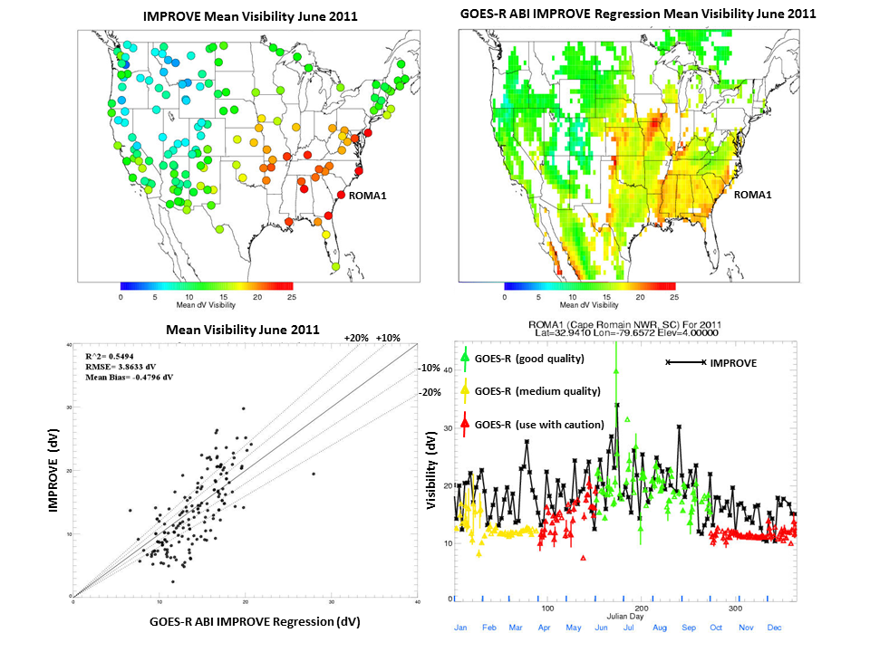 (Click image to enlarge)
 (Click image to enlarge)
VISITORS:
NEXT WEEK:
LOOKING AHEAD:
| Archived Weeklies Page | Submit a report item |