
[ Archive ]

|
ASPB and CIMSS Weekly Report
[ Archive ] |
|
IN THE PRESS:
ITEMS FOR THE ADMINISTRATOR:
ITEMS FOR THE ASSISTANT ADMINISTRATOR:
ITEMS FOR THE OFFICE DIRECTOR, STAR:
Schmit and Team Receives DOC Gold Medal: Tim Schmit and nine other NOAA personnel were awarded the Department of Commerce Gold Medal on January 27, 2015. The citation stated the group “orchestrated the use of retired geostationary weather satellites for improved coverage of South America. These unique efforts included international agreements, satellite processing research and updates, international training and satellite operations. They took what would have been retired satellites and gained an additional six total satellite years of operations from Geostationary Operational Environmental Satellite (GOES)-10 and then GOES-12 imager and sounders for international and domestic uses.” A unique “three year” YouTube animation from the GOES-12 imager (6.5 micrometer) in the remapped mode over South America is available at http://cimss.ssec.wisc.edu/goes/goessa/YouTube_watervapor_GOES-12.html. (J. Key, E/RA2, 608-263-2605, jkey@ssec.wisc.edu; T. Schmit, E/RA2, 608-263-0291, tim.j.schmit@noaa.gov)
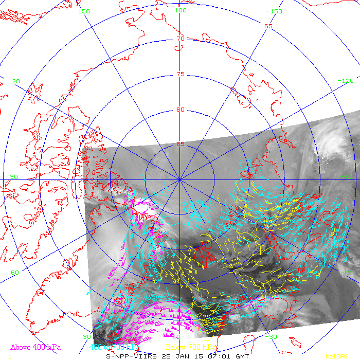
VIIRS Polar Winds Now Generated at Sodankyä, Finland: Visible Infrared Imaging Radiometer Suite (VIIRS) polar winds are now generated on-site at the Sodankyä, Finland direct broadcast site, along with Moderate Resolution Imaging Spectroradiometer (MODIS) winds. This is the second direct broadcast site generating VIIRS winds. The first was Fairbanks, Alaska. There are currently three Arctic and two Antarctic DB sites that generate Advanced Very High Resolution Radiometer (AVHRR), MODIS, and/or VIIRS winds. Current wind images from Sodankyä are available at http://stratus.ssec.wisc.edu/db/sodankyla. (S. Wanzong, CIMSS; J. Key, E/RA2, 608-263-2605, jkey@ssec.wisc.edu)
 (Click image to enlarge)
Figure caption: S-NPP VIIRS polar winds generated at Sodankyä, Finland for one pass on 25 January 2015.
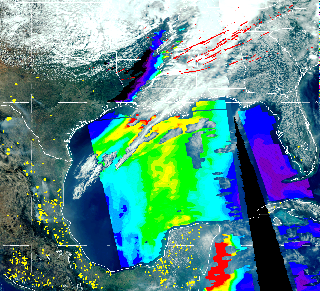
Manuscript on Smoke Influences on Tornado Severity Published: A manuscript entitled “Central American biomass burning smoke can increase tornado severity in the U.S”, by P. E. Saide, S. N. Spak, R. B. Pierce, J. A. Otkin, T. K. Schaack, A. K. Heidinger, A. M. da Silva, M. Kacenelenbogen, J. Redemann, and G. R. Carmichael, was published in Geophysical Research Letters (GRL) on January 26, 2015. The article shows that during the 27 April 2011 historical tornado outbreak, smoke produced by fires in Central America was transported to the southeast US where it could interact with clouds and radiation and produce environmental conditions more favorable to significant tornado occurrence. This work points to the need to consider inclusion of aerosol feedbacks in severe weather forecasting models and assimilation of satellite aerosol optical depth (AOD) retrievals within future “warn-on-forecast” systems to help improve the predictability of these extreme events (R.B. Pierce, E/RA2, 608-890-1892, brad.pierce@noaa.gov, J. Otkin and T. Schaack CIMSS, A. Heidinger, E/RA2)
 (Click image to enlarge)
Figure caption: The image shows Moderate Resolution Imaging Spectroradiometer (MODIS) Aqua satellite products for 27 April 2011 over the southeast US, Central America and the Gulf of Mexico (GoM), along with April 26-28, 2011 tornado tracks (red solid lines) for the historical tornado outbreak. The thickness of the tornado tracks indicates the magnitude of the tornado reports (thickest=5, thinnest=1). The background is a true color image of the surface, clouds and smoke, with yellow markers indicating MODIS fire detections and an iridescent overlay showing aerosol optical depth (AOD). Red, green and purple colors show high (1.0), medium (0.6) and low (0.1) AOD values. The article by Saide et al. (2015) shows that the increase in aerosol loads in the GoM is produced by fires in Central America, and this smoke is further transported to the southeast US where it can interact with clouds and radiation producing environmental conditions more favorable to significant tornado occurrence.
ITEMS FOR THE DIVISION CHIEF, CoRP:
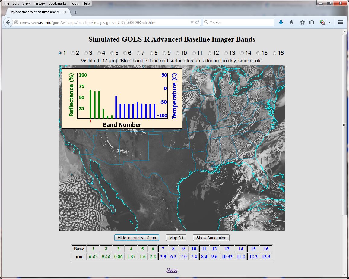
New Spectral Band Education Webapp: As part of the Geostationary Operational Environmental Satellite (GOES)-R Education Proving Ground, a new educational webapp has been developed. This spectral band app (http://cimss.ssec.wisc.edu/goes/webapps/bandapp/) allows users to interactively explore the information from different bands of a given satellite. For example, one can explore the relationship of the six visible and near-infrared bands on the Advanced Baseline Imager (ABI), or the relationship between the visible and infrared bands. Currently there are examples fromm the GOES imager, simulated GOES-R ABI and the "first light" Advanced Himawari Imager (AHI) images. This webapp was developed with the Cooperative Institute for Meteorological Satellite Studies (CIMSS), especially Tom Whittaker, and was showcased at the recent American Meteorological Society (AMS) annual meeting by B. Ward of the National Weather Service (NWS). (T. Schmit, E/RA2, 608-263-0291, tim.j.schmit@noaa.gov; M. Mooney, CIMSS, margaret.mooney@ssec.wisc.edu)
 (Click image to enlarge)
SSEC and CIMSS Media Mentions, January 2015: Data, imagery, and expertise from the Space Science and Engineering Center (SSEC) and the Cooperative Institute for Meteorological Satellite Studies (CIMSS) regularly appear in local, state, and national media. Media mentions for January 2015 include:
 (Click image to enlarge)
VISITORS:
NEXT WEEK:
LOOKING AHEAD:
| Archived Weeklies Page | Submit a report item |