[ Archive ]
| CIMSS-NOAA Weekly Report
[ Archive ] |
IN THE PRESS:
ITEMS FOR THE ADMINISTRATOR:
ITEMS FOR THE ASSISTANT ADMINISTRATOR:
ITEMS FOR THE OFFICE DIRECTOR, STAR:
Journal of Climate Paper Published: A paper appears in this week's Journal of Climate that includes a comparison of the NOAA Pathfinder Atmospheres Extended (PATMOS-x) cloud fraction record to a newly re-calibrated record from surface stations in the USA. The lead author of the paper is Bomin Sun and the title is "Variability and Trends in U.S. Cloud Cover: ISCCP, PATMOS-x, and CLARA-A1 Compared to Homogeneity-Adjusted Weather Observations". The paper compares three satellite records to the surface data and PATMOS-x appears to agree the best. This study is important to help establish the credibility of multi-decadal satellite climate records. Other authors include Andrew Heidinger (NOAA) and Mike Foster (Cooperative Institute for Meteorological Satellite Studies - CIMSS). (A. Heidinger, E/RA2, 608-263-6757, andrew.heidinger@noaa.gov)
World Meteorological Congress Polar Activities: The 17th World Meteorological Congress was held in Geneva, Switzerland, May 25 - June 12, 2015. Jeff Key (STAR) co-organized a special panel discussion on the World Meteorological Organization's (WMO) polar activities, held as a side event on May 28. The panel discussion included the activities of the Global Cryosphere Watch (GCW), the Year of Polar Prediction (YOPP), and other activities of the WMO Executive Council expert panel on Polar Observations, Research, and Services (EC-PORS). It was very well attended, with over 70 participants from around the world, including the directors of many meteorological service agencies. (J. Key, E/RA2, 608-263-2605, jkey@ssec.wisc.edu)
Transition of New Model into National Hurricane Center Operations: A new model constructed by Jim Kossin (National Centers for Environmental Information - Center for Weather and Climate) has been selected for operational implementation at NOAA’s National Hurricane Center (NHC). The model was developed and tested over the past three years as part of the NOAA Joint Hurricane Testbed (JHT) project, and will provide NHC forecasters with enhanced intensity forecast guidance during hurricane eyewall replacement cycles. This latest model will serve as a complement to a model developed by Kossin under a previous JHT project period, which was selected for operational implementation at NHC three years ago. The earlier model provides probability forecasts that a hurricane eyewall cycle will begin. Together, the two models are expected to increase hurricane intensity forecast skill. (Jim Kossin, NCEI/CWC, 608-265-5356)
ITEMS FOR THE DIVISION CHIEF, CoRP:
S-NPP and MODIS Joint Science Team Meeting: Last week, Yue Li (CIMSS) presented material on behalf of Andrew Heidinger at the Suomi-National Polar-orbiting Partnership (S-NPP) and MODerate-resolution Imaging Spectroradiometer (MODIS) Science Team Meeting held in Silver Spring, MD. The briefing explained the use of the NOAA Enterprise Cloud Height Algorithm to construct consistent cloud data records from MODIS and the Visible Infrared Imaging Radiometer Suite (VIIRS). The talk included initial and very promising results of cloud heights based on a merger of data from VIIRS and the Cross Track Infrared Sounder (CrIS). This effort is part of a larger S-NPP project lead by Steve Platnick of NASA Goddard. Other Cooperative Institute for Meteorological Satellite Studies (CIMSS) members on that team and present at the meeting include Steve Ackerman, Robert Holz and Rich Frey. (A. Heidinger, E/RA2, 608-263-6757, andrew.heidinger@noaa.gov)
3rd TEMPO Science Team Meeting: Brad Pierce attended the 3rd NASA Tropospheric Emissions: Monitoring of Pollution (TEMPO) Science Team Meeting at the University of Alabama, Huntsville, AL on May 27-28, 2015. He led a discussion on development of TEMPO plans for early adopters based on the GOES-R Proving Ground approach and presented an update on Observation System Simulation Experiment (OSSE) studies demonstrating the impact of geostationary, hyperspectral (ultra-violet, visible, and infrared) ozone retrievals on regional and urban scale air quality forecasts. TEMPO is the US component of a constellation of geostationary satellites that will be used to monitor global air quality including the Korean Geostationary Environment Monitoring Spectrometer (GEMS) and European Sentinel-4/ Ultra-violet/Visible/Near-Infrared (UVN) and next generation low earth orbit (LEO) measurements from the European TROPOspheric Monitoring Instrument (TROPOMI) Sentinel 5 Precursor mission (R.B. Pierce, E/RA2, 608-890-1892, brad.pierce@noaa.gov)
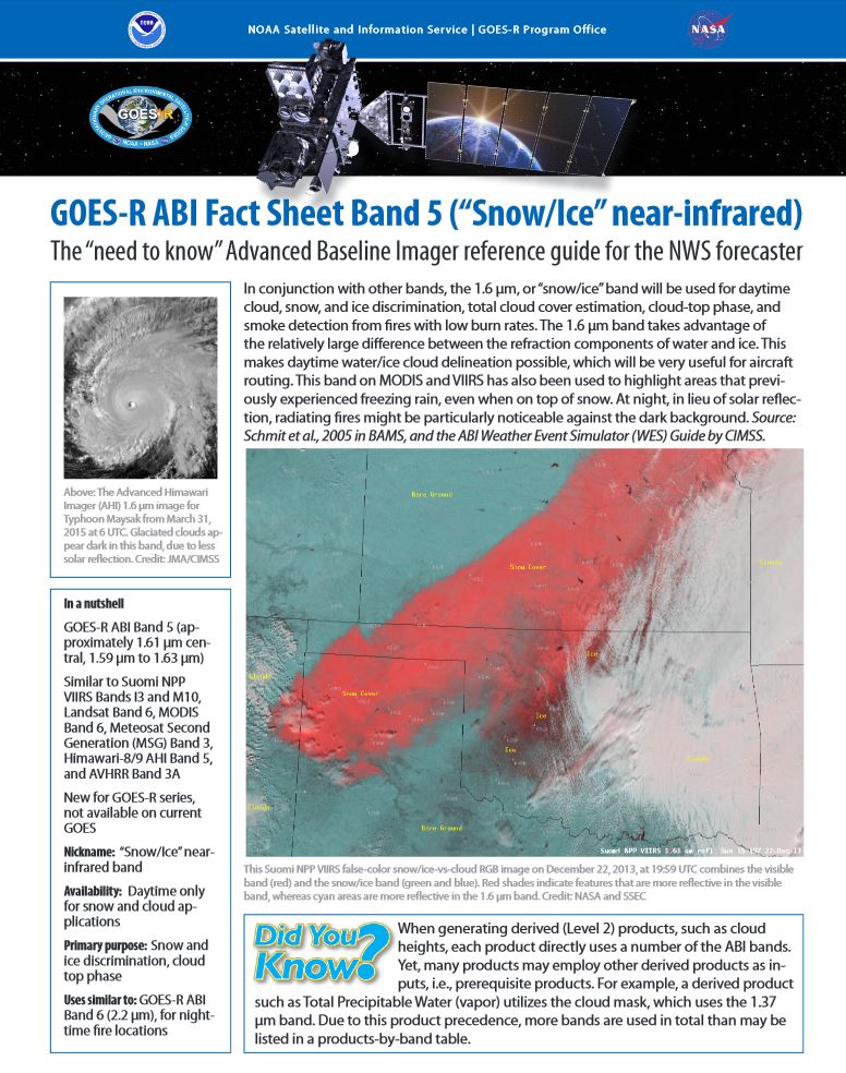
Two More ABI Band Quick Information Sheets: Another two Geostationary Operational Environmental Satellite (GOES) -R series Advanced Baseline Imager (ABI) band fact sheets have been developed and posted. The two bands posted this week were the "cirrus" (1.37 um) and "snow/ice" (1.6 um) bands. These 2-page summaries are meant to be quick references, covering some of the key information relevant to forecasters. This includes imagery, spectral information, uses and many links. The ABI band quick information (fact sheets) are posted at: http://www.goes-r.gov/education/ABI-bands-quick-info.html. (T. Schmit, E/RA2, 608-263-0291, tim.j.schmit@noaa.gov; J. Gerth, CIMSS)
 (Click ihttp://cimss.ssec.wisc.edu/goes/srsor2015/GOES-14_SRSOR.htmlmage to enlarge)
GOES-14 1-minute Imagery: The second week of the 2015 Geostationary Operational Environmental Satellite (GOES)-14 Super Rapid Scan Operations for GOES-R (SRSOR) imagery data collection campaign has been completed, which captured convection over many parts of the central U.S. These 1-minute data are being used to better prepare for the mesoscale mode on the Advanced Baseline Imager (ABI) and were used by several locations, including the Storm Prediction Center (SPC) and the Weather Prediction Center (WPC) in their mesoscale discussions. More information on the daily schedules and image center points: http://cimss.ssec.wisc.edu/goes/srsor2015/GOES-14_SRSOR.html and animations, including the severe convection over Texas and Oklahoma: http://cimss.ssec.wisc.edu/goes/blog/archives/category/goes-14. (T. Schmit, E/RA2, 608-263-0291, tim.j.schmit@noaa.gov; S. Bachmeier, CIMSS, 608-263-3958; S. Lindstrom, CIMSS)
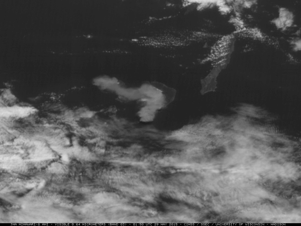
Eruption of the Kuchinoerabu-jima Volcano in Japan: Satellite images and products showing the eruption of the Kuchinoerabu-jima volcano in Japan on May 29, 2015 were posted on the Cooperative Institute for Meteorological Satellite Studies (CIMSS) Satellite Blog (http://cimss.ssec.wisc.edu/goes/blog/archives/18553). The expansion of the volcanic cloud was captured on 0.5-km resolution Himawari-8 visible channel images, and Terra Moderate Resolution Imaging Spectroradiometer (MODIS) retrieved products of volcanic ash height, loading, and effective radius quantitatively characterized the volcanic cloud. (S. Bachmeier, CIMSS, 608-263-3958, M. Pavolonis, E/RA2, 608-263-9597, mpav@ssec.wisc.edu)
 (Click image to enlarge)
VISITORS:
NEXT WEEK:
LOOKING AHEAD:
| Archived Weeklies Page | Submit a report item |