 |
CIMSS-NOAA Weekly Report
[ Archive ] |
 |
CIMSS AND ASPB WEEKLY HIGHLIGHTS FOR THE WEEK ENDING AUGUST 14, 2015
IN THE PRESS:
Two articles on AHI/ABI in the Wired Magazine: Two
articles were posted at the Wired magazine covering Japan’s Advanced
Himawari Imager (AHI) and the Geostationary Operational Environmental
Satellite (GOES)-R Advanced Baseline Imager (ABI). The titles were
“America’s Next Best Weather Satellite? Japan Already Has It” and “What
China’s Huge Tianjin Explosion Looked like from Space”. The articles are
at:
http://www.wired.com/2015/08/americas-next-best-weather-satellite-japan-already/
and
http://www.wired.com/2015/08/chinas-huge-tianjin-explosion-looked-like-space.
A High Definition (HD) version of the true color animation used is at:
http://cimss.ssec.wisc.edu/goes/blog/wp-content/uploads/2015/08/YOuTube_1_6_Aug_Soudelor.html.
(T. Schmit, E/RA2, 608-263-0291, tim.j.schmit@noaa.gov)
ITEMS FOR THE ADMINISTRATOR:
ITEMS FOR THE ASSISTANT ADMINISTRATOR:
ITEMS FOR THE OFFICE DIRECTOR, STAR:
NOAA-CIMSS Hurricane Sandy Supplemental Site Visit: NOAA
Grants Management Division Officer Stacy Tedder and Grants Management
Specialist Raishan Petersen visited UW-CIMSS on Tuesday August 11 to
review seven Sandy funded projects which are in the process of being
completed or have been completed. The site visit was to evaluate state
of research or engineering progress and make sure that financial states
were in order. Present at site visit were project principal
investigators, Nick Novak - UW-Madison Assistant Vice Chancellor
Research Administration (VCRGE), Angela Bitner - Managing Officer
Post-Award Services RSP, Dawn-Marie Roberts - Accountant Senior RSP,
Andrew Heidinger - NOAA ASPB scientist, Jenny Hackel - SSEC Executive
Director for Administration, Steve Ackerman - CIMSS Director, and Wayne
Feltz - SSEC/CIMSS Executive Director for Science. Project overviews
were conducted and Sandy equipment inventory was documented. Site visit
concluded that there were no outstanding issues or findings. (W.
Feltz, CIMSS, 608-265-6283, J. Hackel, SSEC, 608-263-9293, S. Ackerman,
CIMSS, 608-263-3647)
ITEMS FOR THE DIVISION CHIEF, CoRP:
Manuscript on probabilistic prediction of tropical cyclone rapid intensification methods using satellite microwave imagery published in Weather and Forecasting: A manuscript entitled "Improvements in the probabilistic prediction of tropical cyclone rapid intensification with passive microwave observations" by C. M. Rozoff, C. S. Velden, J. Kaplan, J. P. Kossin, and A. J. Wimmers was published in the August issue of Weather and Forecasting (http://journals.ametsoc.org/doi/full/10.1175/WAF-D-14-00109.1). This paper demonstrates how passive microwave imagery of a tropical cyclone's inner-core can improve probabilistic prediction of rapid intensification (RI) events. RI events have ranked among the most difficult tropical cyclone prediction problems. Microwave imagery provides additional information about the tropical cyclone precipitation structure that is not available in other environmental and infrared satellite-based predictors, which turns out to be important in intensity change processes. This probabilistic forecasting scheme has been accepted as a forecasting tool in the National Hurricane Center and will continue to be improved upon by researchers at CIMSS in collaboration with scientists at NOAA. (C. Rozoff, CIMSS, 608-263-6733, chris.rozoff@ssec.wisc.edu)
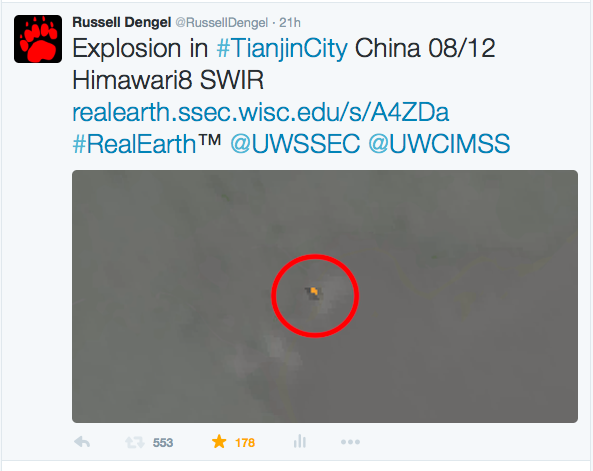
Explosion in Tianjin City viewed via Himawari8 SWIR: 08/12 Expolsion in Tianjin City, China was noted in the 16:40Z Himawari8 Short Wave infrared (3.9um) channel. The attached Tweet was posted using the Space Science and Engineering Centers RealEarth map server. Web traffic caused the server to eventually stall after approximately 30 minutes. As of 08/13 the post has been re-tweeted 553 times with over 170 Favors (R. Dengel, SSEC, 608-262-6567)
 (Click image to enlarge)
Figure caption: Image from SSEC tweet on explosion in Tianjin City in Himawari8 shortwave infrared band (3.9 micrometers)
Two Papers on Volcanic Ash and Dust Detection Published: Two manuscripts describing a new automated technique for detecting volcanic ash and dust using satellite data have been published in the Journal of Geophysical Research-Atmospheres. The papers are entitled “Spectrally Enhanced Cloud Objects – A generalized framework for automated detection of volcanic ash and dust clouds using passive satellite measurements: 1. Multispectral analysis” and “Spectrally Enhanced Cloud Objects – A generalized framework for automated detection of volcanic ash and dust clouds using passive satellite measurements: 2. Cloud object analysis and global application.” The authors are Michael Pavolonis (NOAA/NESDIS/STAR), Justin Sieglaff (Cooperative Institute for Meteorological Satellite Studies, CIMSS), and John Cintineo (CIMSS). The technique described in the manuscripts is being used to help generate near real-time volcanic ash cloud products and alerts, from a variety of satellite sensors, for Volcanic Ash Advisory Center’s and volcano observatories (http://volcano.ssec.wisc.edu). (M. Pavolonis, E/RA2, 608-263-9597, Mike.Pavolonis@noaa.gov, J. Sieglaff, CIMSS, J. Cintineo, CIMSS)
Fog and CLAVR-x CDR: A critical design review (CDR) was held this week for a project that is transitioning the Fog and Low Stratus (FLS) product in NESDIS operations for the current Geostationary Operational Environmental Satellite (GOES) and Advanced Very High Resolution Radiometer (AVHRR) sensors. In addition, this CDR also included the transition of the functionality of the Clouds from AVHRR Extended (CLAVR-x) system into the STAR Algorithm Processing Framework (SAPF). CLAVR-x will be retired once the SAPF processing becomes operational next year. M. Pavolonis and A. Heidinger presented the algorithm theoretical bases of the FLS and CLAVR-x cloud algorithms. (M. Pavolonis, E/RA2, 608-263-9597, mpav@ssec.wisc.edu, A. Heidinger, E/RA2, 608-263-6757, andrew.heidinger@noaa.gov)
Annual GSI Review Committee Meeting: The annual Grid point Statistical Interpolation (GSI) review committee meeting was held in Boulder, CO on August 10, 2015. The GSI review committee is a multi-agency advisory committee to provide guidance and coordinate development of operational data assimilation capabilities. Brad Pierce provided a summary of GSI development activities at NESDIS including incorporation of Microwave Integrated Retrieval System (MIRS) algorithms into GSI to improve quality control of microwave radiances and development of trace gas assimilation capabilities using the Real time Air Quality Modeling System (RAQMS) and GSI as part of a NASA funded Aura reanalysis project (R.B. Pierce, E/RA2, 608-890-1892, brad.pierce@noaa.gov)
Satellite Signature of an Explosion in Tianjin, China: Satellite imagery showing the hot thermal signature and smoke plume resulting from a fatal explosion in Tianjin, China on August 12, 2015 was posted on the Cooperative Institute for Meteorological Satellite Studies (CIMSS) Satellite Blog (http://cimss.ssec.wisc.edu/goes/blog/archives/19209). (S. Lindstrom, CIMSS, 608-263-4425, R. Dengel, SSEC, 608-262-6567, W. Straka, SSEC, 608-262-5128, S. Bachmeier, CIMSS, 608-263-3958)
Japan’s Himawari-8 Imager: From Typhoons to Explosions: There were several Cooperative Institute for Meteorological Satellite Studies (CIMSS) Satellite Blog posts that showcase Japan’s Advanced Himawari Imager (AHI). These cases include: Explosion in Tianjin, China; Typhoon Soudelor approaches Taiwan and Himawari-8 true-color imagery. These posts can be found at: http://cimss.ssec.wisc.edu/goes/blog/archives/category/himawari-8, for example http://cimss.ssec.wisc.edu/goes/blog/archives/19209. This experience with the AHI is better preparing for the use of the Geostationary Operational Environmental Satellite (GOES)-R Advanced Baseline Imager (ABI). (T. Schmit, E/RA2, 608-263-0291, tim.j.schmit@noaa.gov; S. Bachmeier, CIMSS, 608-263-3958; S. Lindstrom, CIMSS)
 (Click image to enlarge)
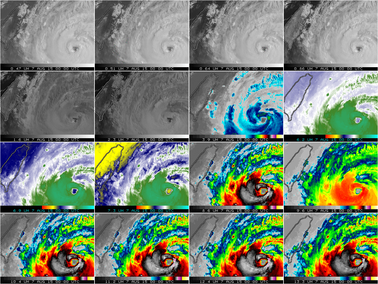
Figure caption: 16 panel Advanced Himawari Imager (AHI) of typhoon Soudelor. There are 3 visible bands, 3 near-infrared bands and 10 infrared bands. This image is from 00 UTC on August 7, 2015.
GOES-14 1-minute Imagery: Fires, Fog and More: The August 2015 Geostationary Operational Environmental Satellite (GOES)-14 Super Rapid Scan Operations for GOES-R (SRSOR) imagery data collection campaign has begun. Several phenomena have been captured, including convection, fires, fog and a tropical system. These 1-minute data are being used to better prepare for the mesoscale mode on the Advanced Baseline Imager (ABI) and were used by several locations, including the Storm Prediction Center (SPC), the Aviation Weather Testbed, and a field experiment focusing on clouds. More information on the daily schedules and image center points: http://cimss.ssec.wisc.edu/goes/srsor2015/GOES-14_SRSOR.html#August and animations: http://cimss.ssec.wisc.edu/goes/blog/archives/category/goes-14. (T. Schmit, E/RA2, 608-263-0291, tim.j.schmit@noaa.gov; S. Bachmeier, CIMSS, 608-263-3958; S. Lindstrom, CIMSS)
 (Click image to enlarge)
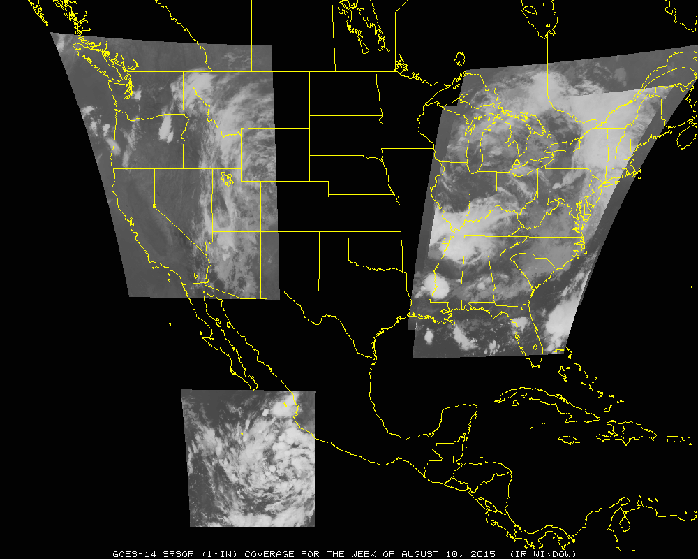
Figure caption: Spatial coverage for the first five days of August 2015 with 1 minute imagery (infrared window).
 (Click image to enlarge)
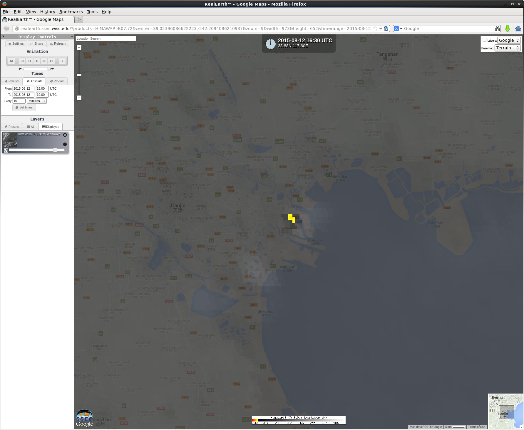
Figure caption: Himawari-8 shortwave infrared (3.9 micrometer) image viewed using SSEC RealEarth, showing the hot thermal signature (yellow pixels) and smoke plumes from an explosion in Tianjin, China on August 12, 2015.
VISITORS:
NEXT WEEK:
LOOKING AHEAD: