[ Archive ]
| CIMSS-NOAA Weekly Report
[ Archive ] |
IN THE PRESS:
ITEMS FOR THE ADMINISTRATOR:
ITEMS FOR THE ASSISTANT ADMINISTRATOR:
ITEMS FOR THE OFFICE DIRECTOR, STAR:
Experimental GOES-14 Imager Data Preparing for GOES-R: During August 10-22, 2015, the Geostationary Operational Environmental Satellite (GOES)-14 Imager was operated in 1-minute mode. These data were used by many, to better help prepare for the high time resolution of the meso-scale sectors on the GOES-R Advanced Baseline Imager (ABI). These data allow for use in operational settings, so GOES-R data can be used quicker once on-orbit. Uses included testbeds (Aviation Weather), field experiments (High Ice Water Content), National Weather Service (NWS) National Centers and many NWS forecast offices. In fact, this data collection included the first ever 1-minute data of a tropical disturbance. The information was used to confirm that intensification was not imminent. High time resolution images of hurricane Danny were also taken. More information can be found at http://cimss.ssec.wisc.edu/goes/blog/archives/category/goes-14 and http://cimss.ssec.wisc.edu/goes/srsor2015/GOES-14_SRSOR.html#August. (T. Schmit, E/RA2, 608-263-0291, tim.j.schmit@noaa.gov) 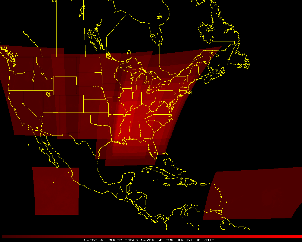 (Click image to enlarge)
Figure caption: The coverage of the GOES-14 Imager sectors during August of 2015. The intensity of the color represents how often each area was scanned.
ITEMS FOR THE DIVISION CHIEF, CoRP:
CIMSS Reports on DOE-1/2 Data: Scientists at the Cooperative Institute for Meteorological Satellite Studies (CIMSS) and Advanced Satellite Products Branch (ASPB), co-located at the University of Wisconsin-Madison, working on Geostationary Operational Environmental Satellite (GOES)-R Algorithm Working Group (AWG) teams have analyzed test data from the GOES-R ground system and reported to NOAA/NESDIS/STAR their findings. The ground system test, called the Data Operations Exercise (DOE)-1&2 (because tests 1 and 2 were combined into one test), used simulated Advanced Baseline Imager (ABI) data that had originally been generated at CIMSS several years ago under the AWG Proxy Data project. The teams that reported, covering over a dozen baseline products, were the Imagery, Soundings, Clouds, Aviation, Winds, Fire, and Algorithm Integration teams. (M. Gunshor, CIMSS, 608-263-1146, and many others).VISITORS:
NEXT WEEK:
LOOKING AHEAD:
| Archived Weeklies Page | Submit a report item |