[ Archive ]
| CIMSS-NOAA Weekly Report
[ Archive ] |
IN THE PRESS:
ITEMS FOR THE ADMINISTRATOR:
ITEMS FOR THE ASSISTANT ADMINISTRATOR:
ITEMS FOR THE OFFICE DIRECTOR, STAR:
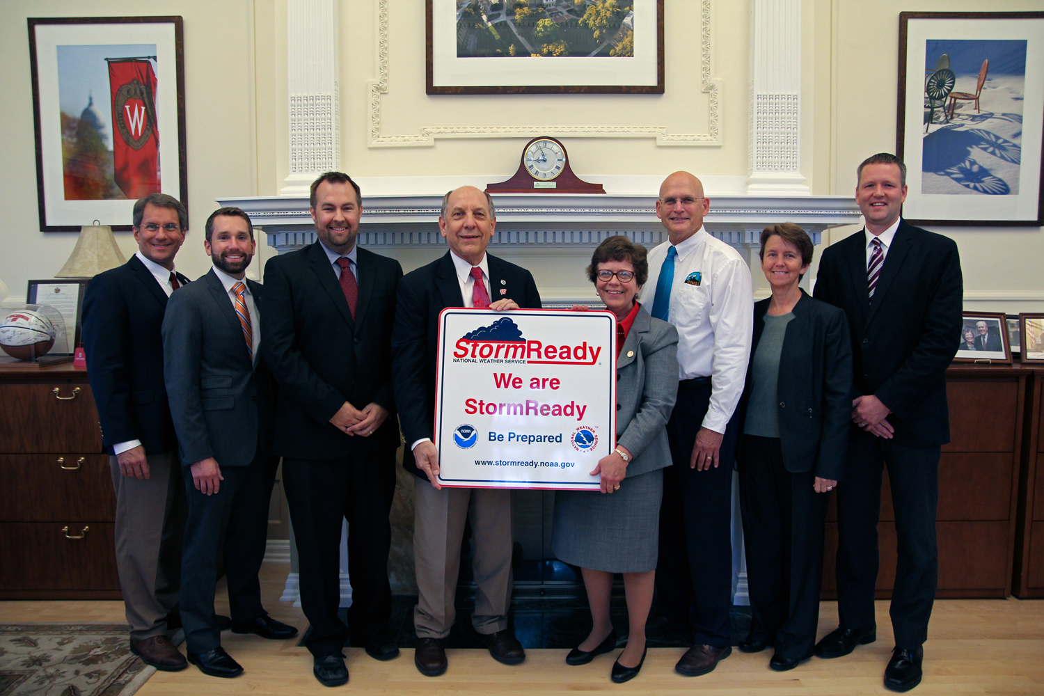
CIMSS leads StormReady University of Wisconsin-Madison Initiative: The University of Wisconsin-Madison (UW) was designated StormReady this week in a short ceremony where NOAA's National Weather Service (NWS) Director Dr. Louis Uccellini presented UW-Madison Chancellor Becky Blank with a special plaque recognizing the collaborative efforts of UW-Madison Police, UW-Madison Emergency Management, the Cooperative Institute for Meteorological Satellite Studies (CIMSS) the UW-Madison Atmospheric and Oceanic Sciences Department and the Milwaukee-Sullivan NWS. This initiative was led by Shane Hubbard from CIMSS, in keeping with CIMSS's Weather-Ready Nation Ambassador status. (Shane Hubbard, CIMSS 608-263-3712, Margaret Mooney, CIMSS, 608-213-5399)
 (Click image to enlarge)
Space Science and Engineering Center 50th Anniversary: The Space Science and Engineering Center (SSEC) at the University of Wisconsin-Madison (UW) celebrated its first half-century of research, discovery, and innovation on September 10, 2015. The UW Board of Regents officially established SSEC on August 20, 1965 with Verner E. Suomi as its first director. With the field of satellite meteorology beginning to emerge, the university’s support allowed SSEC to play a significant role in ushering in a new scientific era. Suomi’s contributions would later earn him the title of “Father of Satellite Meteorology.” In the fifty years since, SSEC scientists, engineers, and leaders have grown an organization with an international reputation for excellence. The 50th Anniversary program featured stories and reminiscences of the people, events, and scientific strides that are central to our past. More information is available at http://www.ssec.wisc.edu/50th/. (J. Phillips, SSEC; J. Key, E/RA2, 608-263-2605, jkey@ssec.wisc.edu)  (Click image to enlarge)
Satellite Products Support NOAA's SHOUT Project: The "Sensing Hazards with Operational Unmanned Technology" (SHOUT) field program is a NOAA-led effort designed to sense high impact oceanic weather hazards to conduct missions for operational prototype data collection and improving forecasts. Specifically, the goal is to determine and quantify the utility of Unmanned Aircraft Systems (UAS) data in the prediction of dangerous storms that can affect the United States. SHOUT will begin with a targeted observing effort using NASA Global Hawk (GH) platforms and payloads, then consider other viable unmanned observing technologies that may be incorporated into the observing strategies as operational prototypes. Operating out of the Wallops Island facility, the GH is currently flying mission into Atlantic hurricanes. The operations center will shift to NASA-Armstrong later this week, with emphasis on eastern Pacific storms. The Cooperative Institute for Meteorological Studies (CIMSS) is supporting SHOUT activities with tailored products from GOES to mitigate weather hazards during flight. These include cloud-top heights, overshooting tops, atmospheric motion vectors, and other derived variables. The GH remote pilots are utilizing these products in real-time mission support and flight track targeting. (C. Velden, CIMSS, 608-262-9168)
Real time simulated ABI imagery now available in AWIPS via NOAAPORT: Real time simulated GOES-R Advanced Baseline Imager (ABI) imagery is now flowing to the Advanced Weather Interactive Processing System (AWIPS) routinely over the NOAAPORT Satellite Broadcast Network (SBN) on the new GOES-R East feed as part of end-to-end testing for GOES-R ABI data delivery. The real time ABI imagery is generated by Cooperative Institute for Meteorological Satellite Studies (CIMSS) and Advanced Satellite Products Branch (ASPB) GOES-R Algorithm Working Group (AWG) proxy data team. Meteorological and cloud forecasts from Global Forecast System (GFS) meteorological are combined with aerosol forecasts from the Real-time Air Quality Modeling System (RAQMS) and the Community Radiative Transfer Model (CRTM) to generate the full-disk 16 band ABI imagery. Nested RAQMS/Weather Research and Forecasting with Chemistry (WRF-CHEM) meteorological, cloud and aerosol forecasts are used with the CRTM over the continental US (R.B. Pierce, E/RA2, 608-890-1892, brad.pierce@noaa.gov, J. Gerth, A. Lenzen, K. Bah, M. Rogal, T. Greenwald, CIMSS) 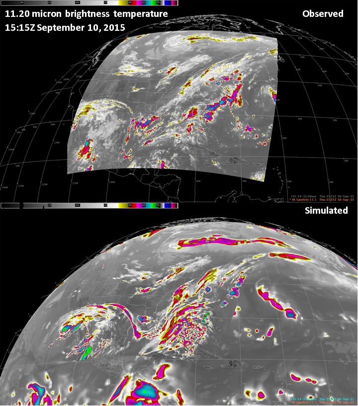 (Click image to enlarge)
Figure caption: GOES-E observed (upper panel) and real time GOES-R ABI simulated (lower panel) 11.2 micron brightness temperatures at 15:15Z on September 10, 2015 from AWIPS screen captures at the CIMSS Analysis and Visualization Environment (CAVE).
ITEMS FOR THE DIVISION CHIEF, CoRP:
Suomi NPP Day/Night Band Captures Stunning Images of the Aurora Borealis : Stunning images of the Aurora Borealis were captured by the Suomi National Polar-orbitting Partnership (NPP) this week by the Day/Night Band on the Visible Infrared Imaging Radiometer Suite (VIIRS). Highly sensitive to light, the Day/Night Band provides new views of the northern lights not possible before the Suomi NPP mission. Images from September 9th were especially popular on the Cooperative Institute for Meteorological Satellite Studies(CIMSS) social media outlets, garnering more than 10,000 views on Facebook and 146 re-tweets on Twitter. Imagery and more information was also featured on the CIMSS Satellite Blog at http://cimss.ssec.wisc.edu/goes/blog/archives/19499. (M. Mooney, CIMSS, 608 213 5399, S. Bachmeier, CIMSS, 608-263-3958)
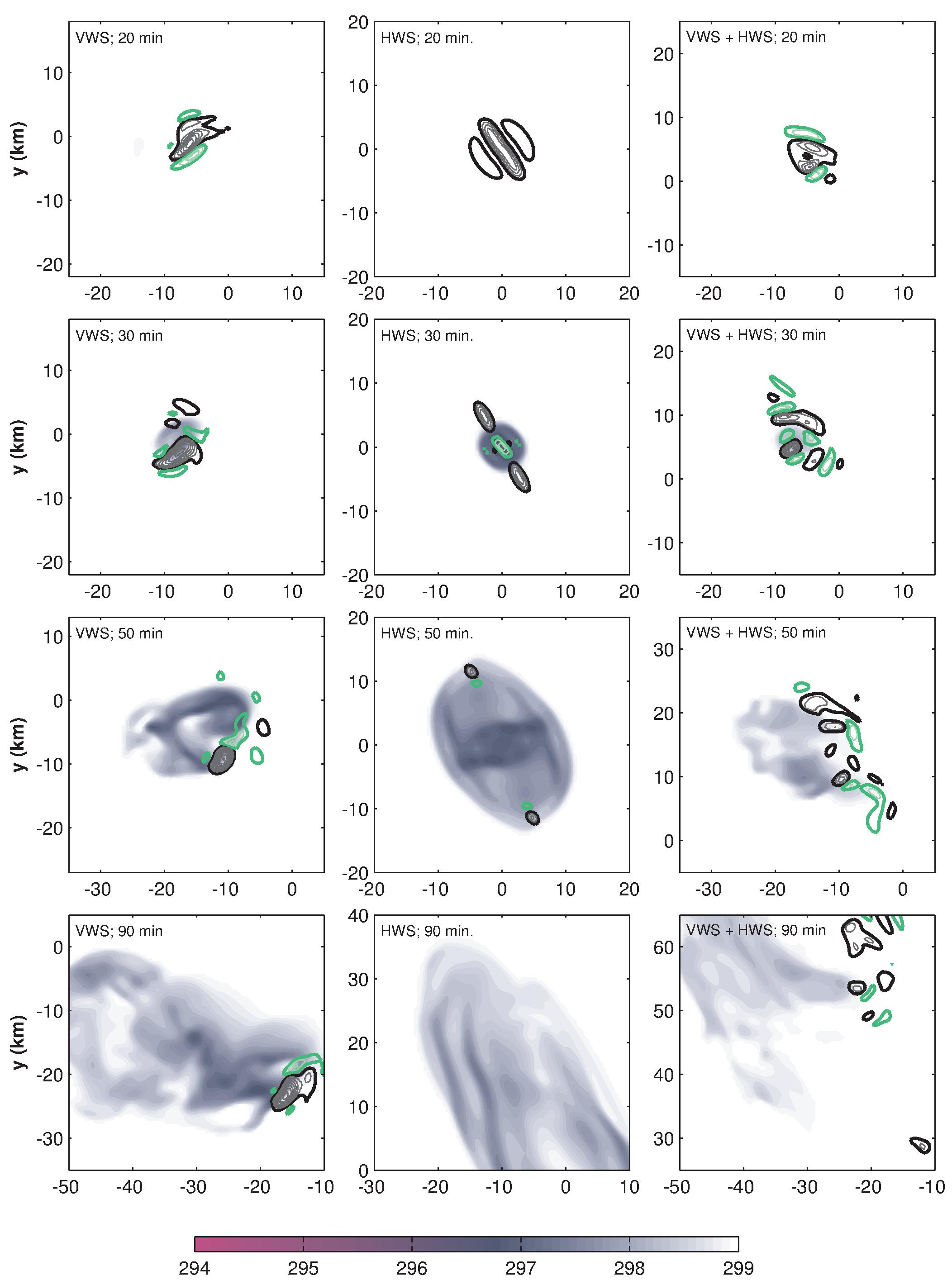
Manuscript Exploring the Dynamics of Complexly Sheared Tropical Cyclone Convection Submitted: A manuscript entitled "The dynamics of complexly sheared tropical cyclone convection" by C. M. Rozoff and W. Terwey was submitted for publication in the Journal of Atmospheric Sciences. The kinematic and thermodynamic controls on convective morphology often vary considerably in a tropical cyclone (TC), but the impact of these variations on convective dynamics is complex and has not heretofore been fully examined. In the TC inner-core, low-level vertical wind shear (VWS) and horizontal wind shear (HWS) can be intense, but it is unknown whether the VWS more often drives vigorous, rotating updrafts or whether strong HWS suppresses convection. This manuscript uses a high-resolution cloud model to address this question and to more generally explore complexly sheared tropical cyclone convection, providing new insight into the morphology and dynamics of convection in unique TC inner-core environments. (C. Rozoff, CIMSS, 608-263-6733)
 (Click image to enlarge)
VISITORS:
NEXT WEEK:
LOOKING AHEAD:
| Archived Weeklies Page | Submit a report item |