[ Archive ]
| CIMSS-NOAA Weekly Report
[ Archive ] |
IN THE PRESS:
ITEMS FOR THE ADMINISTRATOR:
ITEMS FOR THE ASSISTANT ADMINISTRATOR:
ITEMS FOR THE OFFICE DIRECTOR, STAR:
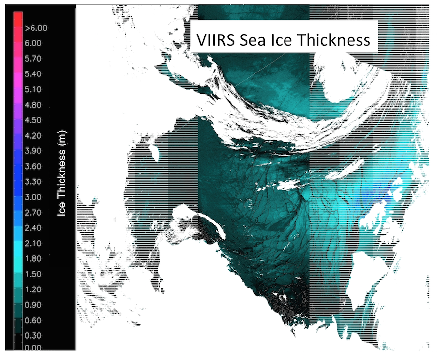
President Obama Mentions New NOAA Ice Thickness Product: President Obama visited Alaska in late August/early September and said that in 2015 NOAA will announce the availability of a new operational Arctic sea-ice thickness satellite product (http://go.wh.gov/UZS4si and http://goo.gl/S3effQ). The product was not mentioned by name, but the NESDIS Chief of Staff confirmed that it was a reference to the NPP/JPSS VIIRS ice thickness product that was developed by the Cooperative Institute for Meteorological Satellites Studies (CIMSS; Xuanji Wang) and STAR, and is being implemented by STAR for operational production in 2016. This and other Presidential commitments announced in Alaska will be tracked by Arctic Executive Steering Committee (AESC), which was recently created by Executive order. The STAR Laboratory for Satellite Altimetry will also have a sea ice thickness product in the coming years based on altimeter data. (J. Key, E/RA2, 608-263-2605, jkey@ssec.wisc.edu)
 (Click image to enlarge)
Cloud Team Presentations at EUMETSAT Meeting: Several presentations from the Joint Polar Satellite System (JPSS) and the Geostationary Operational Environmental Satellite R-Series (GOES-R) Cloud Teams were given at the annual meeting for the European Organisation for the Exploitation of Meteorological Satellites (EUMETSAT) held in Toulouse, France. Andrew Heidinger presented work on the benefits of combining sounder and imager data to improve cloud height estimation. He also presented an analysis of the variability in Tropical convection as seen from NOAA satellites over the past 4 decades. Andi Walter presented talks on the quantitative use of the Day-Night-Band from the Visible Infrared Imaging Radiometer Suite (VIIRS) and on the progress of a working group he leads to improve the performance of cloud remote sensing over snow covered surfaces. Mike Foster gave a keynote presentation on the general topic of the stability of satellite cloud climatologies and results of experiments to determine to stability of the NOAA Pathfinder Extended (PATMOS-x) satellite cloud climate data set. (A. Heidinger, E/RA2, 608-263-6757, andrew.heidinger@noaa.gov)
ITEMS FOR THE DIVISION CHIEF, CoRP:
Manuscript on Hyperspectral Sounder Retrievals Published: A manuscript titled “The use of hyperspectral sounding information to monitor atmospheric tendencies leading to severe local storms” by E. Weisz, N. Smith, and W. Smith Sr. was published in the AGU journal Earth and Space Science (available at http://onlinelibrary.wiley.com/doi/10.1002/2015EA000122-T/full). The authors investigate how retrievals from all operational hyperspectral sounders, which are the Atmospheric Infrared Sounder (AIRS), the Infrared Atmospheric Sounding Interferometer (IASI) and the Cross-track Infrared Sounder (CrIS), can be used in time series to monitor severe local storms. The specific case discussed is the Moore, Oklahoma, tornadic event of 2013.(E. Weisz, CIMSS, 608-265-3954)VISITORS:
GINA Alaska Personnel Visit CIMSS: Jay Cable and Carl Dierking of the Geographic Information Network of Alaska (GINA) visited the Cooperative Institute for Meteorological Satellite Studies (CIMSS) at the University of Wisconsin-Madison for face-to-face discussions on current and future collaborations. Jay and Carl made presentations on the upgrades made to their polar direct broadcast capabilities from the NOAA Hurricane Sandy Supplement money they received. Part of this funding was sub-contracted to CIMSS to support the Visible Infrared Imaging Radiometer Suite (VIIRS), MODerate Resolution Imaging Spectroradiometer (MODIS) and Advanced Very High Resolution Radiometer (AVHRR) imager data reproductions and reformatting for display in the National Weather Service (NWS) Advanced Weather Interactive Processing System-II (AWIPS-II). This effort culminated in the use of the NOAA Community Satellite Processing Package (CSPP) Polar2Grid software to perform this task with every VIIRS and AVHRR band, and 24 of 36 MODIS bands received and processed by GINA direct broadcast antennas. The feed of this data from direct broadcast to the Alaska National Weather Service began operationally this week. (K. Strabala, CIMSS, 608-263-8752, J. Gerth, CIMSS, 608-263-4942).
NEXT WEEK:
LOOKING AHEAD:
| Archived Weeklies Page | Submit a report item |