[ Archive ]
| CIMSS-NOAA Weekly Report
[ Archive ] |
IN THE PRESS:
ITEMS FOR THE ADMINISTRATOR:
ITEMS FOR THE ASSISTANT ADMINISTRATOR:
ITEMS FOR THE OFFICE DIRECTOR, STAR:
World Meteorological Organization Meetings on Operational Volcanic Cloud Monitoring and Forecasting: Mike Pavolonis (NOAA/NESDIS/STAR) attended the World Meteorological Organization (WMO) Seventh International Volcanic Ash Workshop in Anchorage, Alaska from October 19-23, 2015. The primary objective of the WMO workshop, subtitled “Science into Operations, Now and into the Future,” was to improve the scientific aspects of operational volcanic cloud warnings for aviation. NOAA issues volcanic ash advisories for a very large domain that stretches from the Western Pacific to the Eastern Caribbean and from Alaska to Ecuador. Thus, volcanic clouds are directly relevant to NOAA’s operational mission. The satellite remote sensing research being conducted by NOAA/NESDIS/STAR is a major contributor to the international effort to improve operational volcanic cloud applications, and work is underway to combine the STAR volcanic cloud products with many of the non-satellite data sources and dispersion models discussed at the workshop. Immediately following the volcanic ash workshop, M. Pavolonis participated in a meeting of the WMO Volcanic Ash Science Advisory Group (VASAG) from October 23-24, 2015. The VASAG is responsible for ensuring that only the best science is utilized for operational volcanic cloud applications. (M. Pavolonis, E/RA2, 608-263-9597, Mike.Pavolonis@noaa.gov)
ITEMS FOR THE DIVISION CHIEF, CoRP:
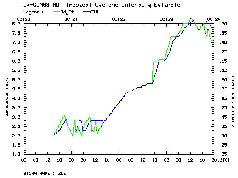
Hurricane Patricia, Likely the Most Intense Ever: Hurricane Patricia will likely go down as the most intense storm ever observed in the Western Hemisphere. The Advanced Dvorak Technique (ADT) pegged the maximum winds at 175mph. The ADT utilizes GOES imagery to objectively deduce storm structure and estimate intensity. The ADT intensity estimates will play a crucial role along with aircraft reconnaissance observations in determining the final Best Track intensity for Patricia, and ultimately if the hurricane will keep its place at the top of the records book. (C. Velden, CIMSS, 608-262-9168; T. Olander, CIMSS, 608-265-8005)
 (Click image to enlarge)
VISITORS:
NEXT WEEK:
LOOKING AHEAD:
| Archived Weeklies Page | Submit a report item |