[ Archive ]
| CIMSS-NOAA Weekly Report
[ Archive ] |
IN THE PRESS:
ITEMS FOR THE ADMINISTRATOR:
ITEMS FOR THE ASSISTANT ADMINISTRATOR:
ITEMS FOR THE OFFICE DIRECTOR, STAR:
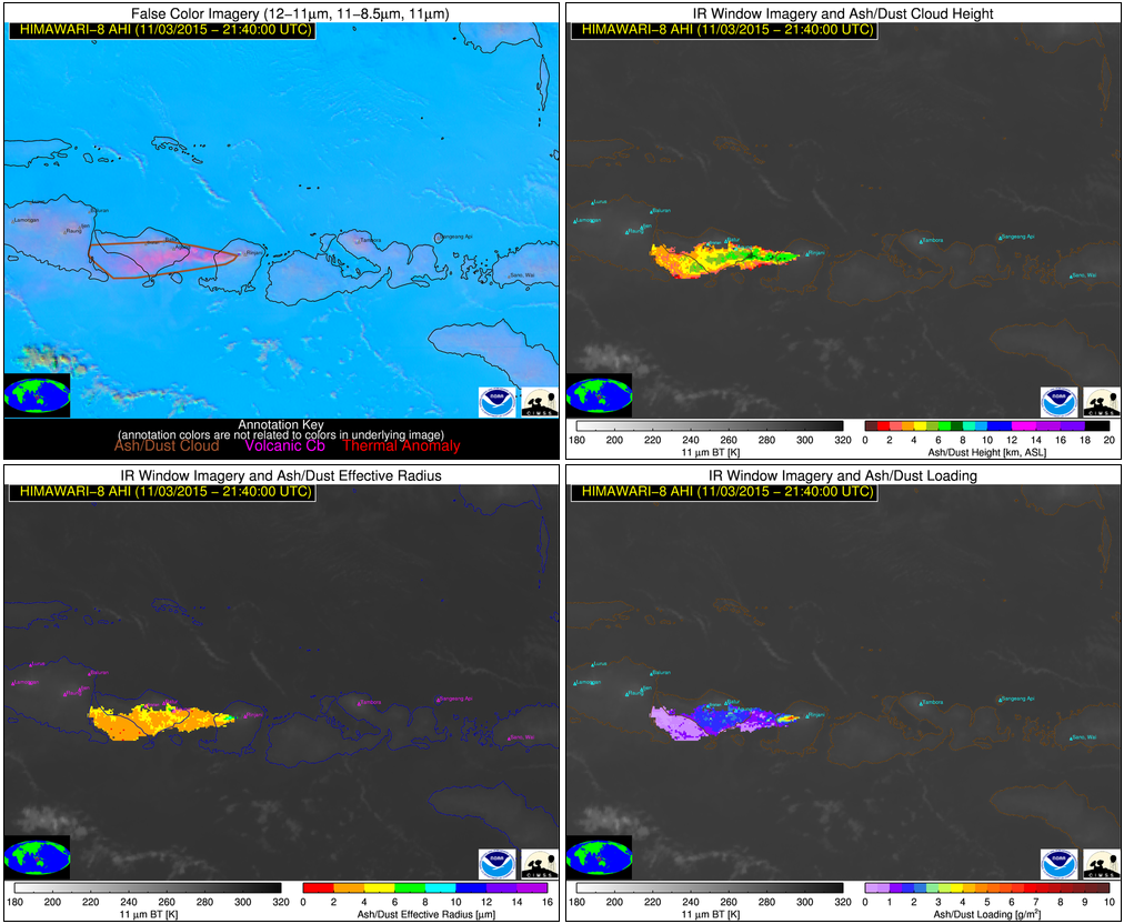
Support for Operational Volcanic Ash Cloud Tracking in Indonesia: During the week of November 1, 2015, persistent volcanic ash emissions from Mount Rinjani severely disrupted air travel in regions of Indonesia popular with tourists, including Bali. The quantitative satellite-based volcanic cloud products developed by NOAA/NESDIS/STAR, in collaboration with the Cooperative Institute for Meteorological Satellite Studies (CIMSS), are supporting operational efforts to track and characterize the hazardous Rinjani ash clouds. The Australian Bureau of Meteorology and Indonesian authorities are using the near real-time volcanic cloud products, derived from Japanese Meteorological Agency (JMA) Himawari-8 satellite measurements, to assist in operational decision-making. Himawari-8 has very similar capabilities as the next generation of Geostationary Operational Environmental Satellites (GOES-R). As such, the generation of products from Himawari-8 measurements not only fosters collaboration with NOAA’s international partners, but also demonstrates GOES-R capabilities. The near real-time NOAA/NESDIS/STAR/CIMSS volcanic cloud products are available at http://volcano.ssec.wisc.edu/imagery/view/ and additional images are available on the CIMSS Satellite Blog (http://cimss.ssec.wisc.edu/goes/blog/archives/20017). (M. Pavolonis, E/RA2, 608-263-9597, Mike.Pavolonis@noaa.gov, J. Sieglaff, CIMSS, J. Cintineo, CIMSS, S. Bachmeier, CIMSS, S. Lindstrom, CIMSS)
 (Click image to enlarge)
Figure caption: A volcanic ash plume from Mount Rinjani extends westward over Bali, Indonesia on November 3, 2015 (21:40 UTC). The ash emissions from Mount Rinjani are automatically tracked and characterized using the NOAA/NESDIS/STAR volcanic cloud algorithms and Himawari-8 satellite measurements. Multi-spectral imagery (top left), ash cloud height (top right), ash effective radius (bottom left), and ash loading (bottom right), derived from Himawari-8, are shown.
ITEMS FOR THE DIVISION CHIEF, CoRP:
VISITORS:
NEXT WEEK:
LOOKING AHEAD:
| Archived Weeklies Page | Submit a report item |