[ Archive ]
| CIMSS-NOAA Weekly Report
[ Archive ] |
IN THE PRESS:
ITEMS FOR THE ADMINISTRATOR:
ITEMS FOR THE ASSISTANT ADMINISTRATOR:
ITEMS FOR THE OFFICE DIRECTOR, STAR:
SSEC/CIMSS Rooftop Antenna Upgraded for Future GOES-R Reception: The University of Wisconsin SSEC’s 7.3 meter antenna, located on the southwest corner of the penthouse roof on top of the 15 story Atmospheric and Oceanic Science (AOS) building, has been upgraded in preparation for the reception of GOES Rebroadcast (GRB) after the launch of GOES-R in October 2016. The upgrade, which includes a new feed, a new mounting plate, new cabling, and a new demodulator, was completed in late September 2015. Since the new feed is compatible with the existing GVAR broadcast, the GVAR reception was tested while pointed at GOES-15 (135 W) during October and November of 2015. The upgraded antenna can be pointed at any geostationary satellite between 75 W and 137 W. (W. Feltz, CIMSS, 608-265-6283, J. Robaidek) 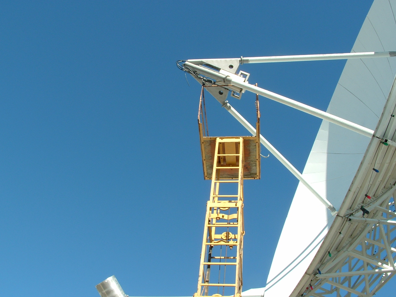 (Click image to enlarge)
Paper Published on Ice Surface Temperature Validation: A paper titled "Validation of the Suomi NPP VIIRS Ice Surface Temperature Environmental Data Record", by Y. Liu, J. Key, M. Tschudi, R. Dworak, R. Mahoney, and D. Baldwin, was published in the journal Remote Sensing (2015, 7, 17258–17271; doi:10.3390/rs71215880). It is part of a special issue on Suomi NPP calibration and validation. The paper examines the quality of the VIIRS IST environmental data record (EDR) through comparisons with aircraft measurements, drifting ice buoys, atmospheric reanalyses, and other satellite products. (J. Key, E/RA2, 608-263-2605, jkey@ssec.wisc.edu; Y. Liu, CIMSS, 608-265-8620)
ITEMS FOR THE DIVISION CHIEF, CoRP:
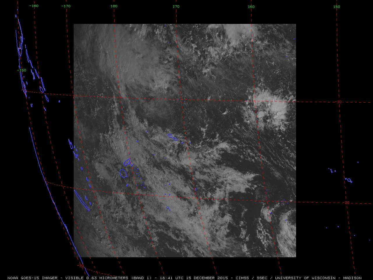
GOES-15 American Samoa RSO Test: A new Geostationary Operational Environmental Satellite (GOES)-15 (GOES-West) Rapid Scan Operations (RSO) sector was tested on December 15, 2015. The sector is centered over American Samoa in the South Pacific Ocean. The imagery was ingested both via Man computer Interactive Data Access System (McIDAS) and Advanced Weather Interactive Processing System (AWIPS). More information can be found on the Cooperative Institute for Meteorological Satellite Studies (CIMSS) Satellite Blog at http://cimss.ssec.wisc.edu/goes/blog/archives/20239. (T. Schmit, E/RA2, 608-263-0291, tim.j.schmit@noaa.gov; J. Gerth, CIMSS, 608-263-4942; S. Bachmeier, CIMSS, 608-263-3958)
 (Click image to enlarge)
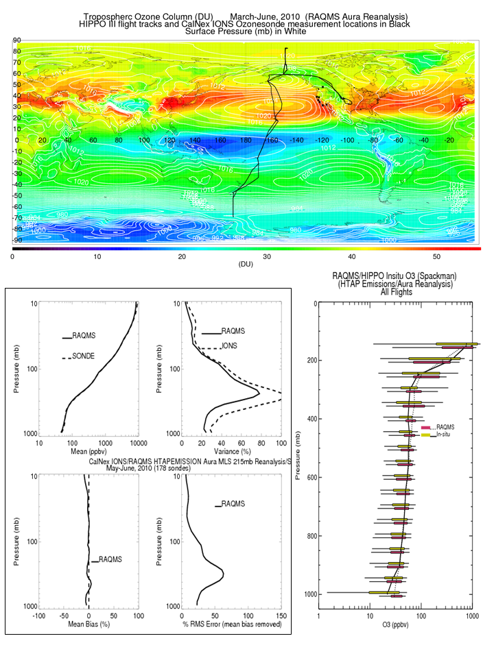
2015 Fall American Geophysical Union (AGU) meeting Invited Talks: Brad Pierce gave an invited talk entitled “Development of an Aura Chemical Reanalysis in support Air Quality Applications” at the 2015 Fall American Geophysical Union (AGU) meeting in San Francisco, CA. He presented results of chemical data assimilation experiments utilizing the NOAA NESDIS, University of Wisconsin Space Science and Engineering Center (SSEC) Real-time Air Quality Modeling System (RAQMS) in conjunction with the NOAA National Centers for Environmental Prediction (NCEP) Operational Gridpoint Statistical Interpolation (GSI) 3-dimensional variational data assimilation system. The impact of assimilating NASA Ozone Monitoring Instrument (OMI) total column ozone, OMI tropospheric nitrogen dioxide columns, and Microwave Limb Sounder (MLS) stratospheric ozone profiles on background ozone was assessed using measurements from the 2010 NSF High-performance Instrumented Airborne Platform for Environmental Research (HIAPER) Pole-to-Pole Observation (HIPPO) and NOAA California Nexus (CalNex) campaigns. Comparisons show that the RAQMS Aura Reanalysis captures the ozone distribution in the stratosphere and troposphere over the Pacific very well and is suitable for use in characterizing tropospheric background ozone distributions and their impact on ozone over the US. Andrew Heidinger also attended and gave two oral presentations. The first was invited and described the issues being faced in making continuous cloud climate records from the NASA Moderate Resolution Imaging Spectroradiometer (MODIS) and the Visible and Infrared Imaging Radiometer Suite (VIIRS). The second was a exploration of the variation in deep convection seen in the 35 years of NESDIS Advanced Very High Resolution Radiometer (AVHRR). He also chaired a session of the application of long term climate records. (R.B. Pierce, E/RA2, 608-890-1892, brad.pierce@ssec.wisc.edu; A. Heidinger, E/RA2, 608-263-6757, andrew.heidinger@noaa.gov)
 (Click image to enlarge)
VISITORS:
NEXT WEEK:
LOOKING AHEAD:
| Archived Weeklies Page | Submit a report item |