[ Archive ]
| CIMSS-NOAA Weekly Report
[ Archive ] |
IN THE PRESS:
ITEMS FOR THE ADMINISTRATOR:
ITEMS FOR THE ASSISTANT ADMINISTRATOR:
ITEMS FOR THE OFFICE DIRECTOR, STAR:
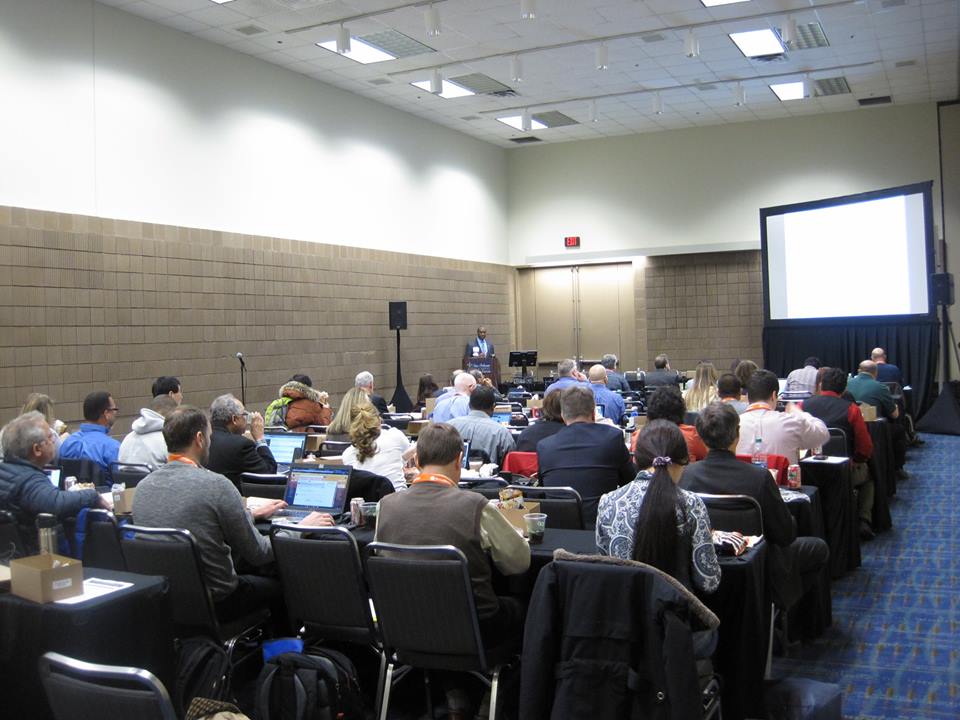
CIMSS and ASPB Support GOES-R/JPSS AMS Short Course: Scientists from the Cooperative Institute for Meteorological Satellite Studies (CIMSS) and the NOAA Advanced Satellite Products Branch (ASPB) helped organize and led a short course at the American Meteorological Society (AMS) Annual Meeting, focused on Geostationary Operational Environmental Satellite (GOES)-R and Joint Polar Satellite System (JPSS) instruments and new capabilities. The short course, titled "AMS Short Course on the Geostationary Operational Environmental Satellite (GOES)-R and Joint Polar Satellite System (JPSS)" had high attendance with nearly 50 people signing up, including Certified Consulting Meteorologists (CCMs), broadcast meteorologists, researchers, forecasters, and international partners including from Canada, Mexico, and Japan. Presentations, including links to hands-on activities are available at http://cimss.ssec.wisc.edu/goes/shortcourse/links.html. All CIMSS/ASPB participation in the AMS Annual Meeting will be summarized in next week's report. (M. Gunshor, CIMSS, 608-263-1146, T. Schmit, E/RA2, 608-263-0291, tim.j.schmit@noaa.gov, J. Gerth, CIMSS, C. Schmidt, CIMSS, S. Lindstrom, CIMSS)
 (Click image to enlarge)
Figure caption: Dr. Marshall Shepherd delivering the lunch-time presentation at the GOES-R/JPSS AMS Short Course in New Orleans.
Manuscript Assessing the Evolution of the 2012 U.S. Flash Drought Published: A manuscript entitled “Assessing the evolution of soil moisture and vegetation conditions during the 2012 United States flash drought” by Jason Otkin et al. was published online in Agricultural and Forest Meteorology and will appear in print in the March 2016 issue. This paper examined the evolution of several satellite-derived and model-based drought indices sensitive to soil moisture and vegetation conditions during this flash drought event. Comparisons were made between the drought metrics and various soil moisture and crop datasets compiled by the U.S. Department of Agriculture. The results showed that there was a strong relationship between the GOES-derived Evaporative Stress Index and the end of season crop yields for corn, soybeans, and wheat, and also closely matched observed changes in crop health conditions. (J. Otkin, CIMSS, 608-265-2476)
ITEMS FOR THE DIVISION CHIEF, CoRP:
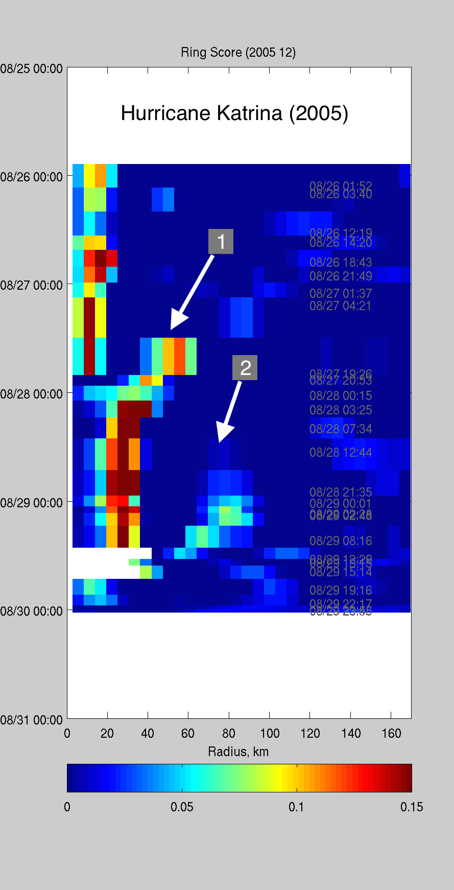
Proof-of-Concept in New R2O Project: A new research-to-operations project, which is being lead by Cooperative Institute for Meteorological Satellite Studies (CIMSS) scientists Tony Wimmers and Derrick Herndon, and Jim Kossin of NOAA's National Centers for Environmental Information (NCEI), is now underway. The project’s goal is to add satellite microwave data to existing operational models at the National Hurricane Center to improve hurricane forecast skill during eyewall replacement cycles (ERCs). The method exploits an existing operational model (named ARCHER) that was originally designed to use microwave brightness temperature evolution to locate storm center, but was modified here to identify secondary concentric eyewall formation. As an initial proof-of-concept experiment, the model was applied to past cases of ERCs to see if easily identifiable patterns emerge. In all cases, clear signals of ERCs emerged that have apparently predictive behavior. An example in the figure below shows the time evolution of the modified ARCHER “ring score” as a function of distance from storm center during Hurricane Katrina. The first ERC (labeled “1”) led to a rapid expansion of Katrina’s wind field while in the Gulf of Mexico. This expansion event then led to the ultimately great destructiveness of Katrina’s storm surge during landfall. The second ERC lead to a weakening of Katrina’s maximum winds just prior to landfall. Both ERCs had extensive effects on coastal impacts. These initial results are highly encouraging and confirm the proof-of-concept for the project. The project, which began in August 2015, is supported by the NOAA Joint Hurricane Testbed Project for the development, testing and transition to NHC operations of new forecast models. (J. Kossin, NCEI/CWC, 608-265-5356)
 (Click image to enlarge)
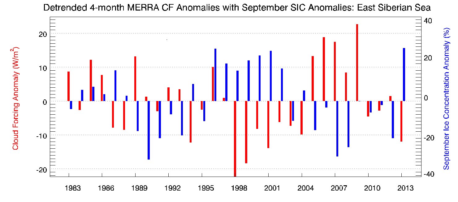
Recent work links Arctic Winter Clouds with Summer Sea Ice: Research combining modeled and remotely-sensed Arctic cloud data with passive microwave ice concentrations supports the idea that wintertime clouds can help predict summertime sea ice conditions. Many times over the last 30 years, areas of the Chukchi and East Siberian Seas have experienced inverse relationships between winter cloud cover anomalies and ice concentration the following summer. Recently submitted for publication to JGR-Atmospheres, this work demonstrates the long-term, regional changes that clouds impose on sea ice and also examines the role of winter clouds in the 2007 sea ice minimum. (A. Letterly, CIMSS, J. Key, E/RA2, 608-263-2605, jkey@ssec.wisc.edu, and Y. Liu, CIMSS, 608-265-8620).
 (Click image to enlarge)
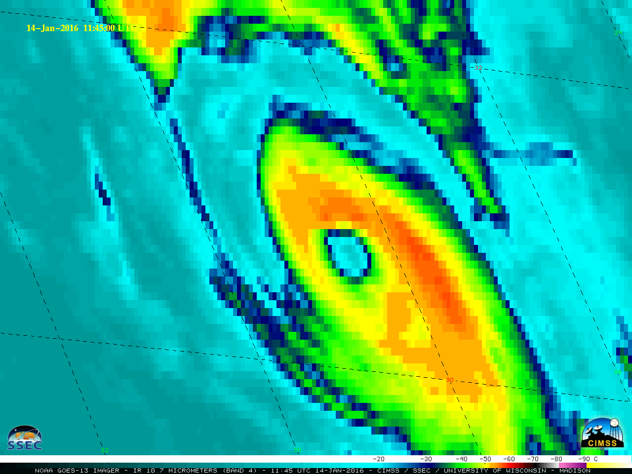
Satellite Images of Hurricane Alex in the Atlantic Ocean: Satellite images of Hurricane Alex were posted on the Cooperative Institute for Meteorological Satellite Studies (CIMSS) Satellite Blog (http://cimss.ssec.wisc.edu/goes/blog/archives/20483). Alex (which transitioned from a subtropical storm to a hurricane on January 14, 2016) was the first known Atlantic hurricane during the month of January since 1938. (S. Bachmeier, CIMSS, 608-263-3958, W. Straka, SSEC)
 (Click image to enlarge)
Ozone manuscript submitted to Environmental Science & Technology: A manuscript entitled “Interannual variability in baseline ozone and its relationship to surface ozone in the western U.S." by Pao Baylan, Dan Jaffe, R. Bradley Pierce, and Mae Gustin was submitted to Environmental Science & Technology. The manuscript uses springtime surface ozone measurements from the Mt. Bachelor Observatory (MBO) and tropospheric ozone analyses from the Real-time Air Quality Modeling System (RAQMS) to investigate the role of inter annual variations in background ozone on increasing springtime ozone at MBO (R.B. Pierce, E/RA2, 608-890-1892, brad.pierce@noaa.gov)
VISITORS:
NEXT WEEK:
LOOKING AHEAD:
| Archived Weeklies Page | Submit a report item |