[ Archive ]
| CIMSS-NOAA Weekly Report
[ Archive ] |
IN THE PRESS:
ITEMS FOR THE ADMINISTRATOR:
ITEMS FOR THE ASSISTANT ADMINISTRATOR:
ITEMS FOR THE OFFICE DIRECTOR, STAR:
ITEMS FOR THE DIVISION CHIEF, CoRP:
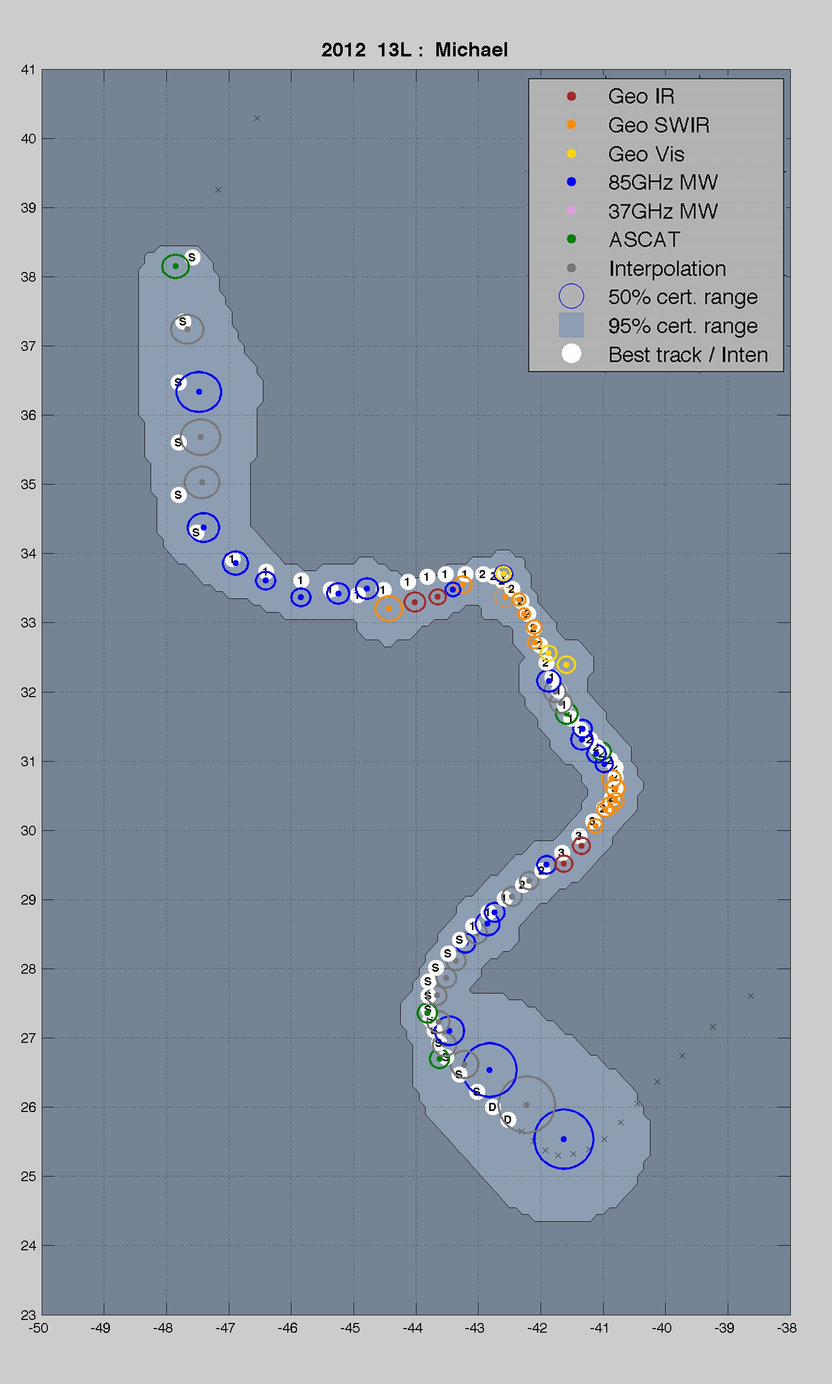
Publication of Hurricane Center-finding Algorithm: A paper by Anthony Wimmers and Chris Velden was published a paper in the latest issue of Journal of Applied Meteorology and Climatology. The paper, titled "Advancements in Objective Multisatellite Tropical Cyclone Center Fixing", presents an updated version of the ARCHER algorithm, which produces an automated tropical cyclone center-fix using IR window, near IR, visible, passive microwave or scatterometer imagery, and uses a uniform standard for estimating the expected error. Applications include providing a complement to the operational forecasting process, and furnishing other automated tropical cyclone analysis methods with objective center-fix information. This is of considerable interest to the National Hurricane Center and other interests in the U.S. that practice real-time tracking of tropical cyclones. The online version links to a downloadable package of the algorithm code, to promote wider usage and begin a stage of more open development. (T. Wimmers, CIMSS; C. Velden, CIMSS, 608-262-9168)
 (Click image to enlarge)
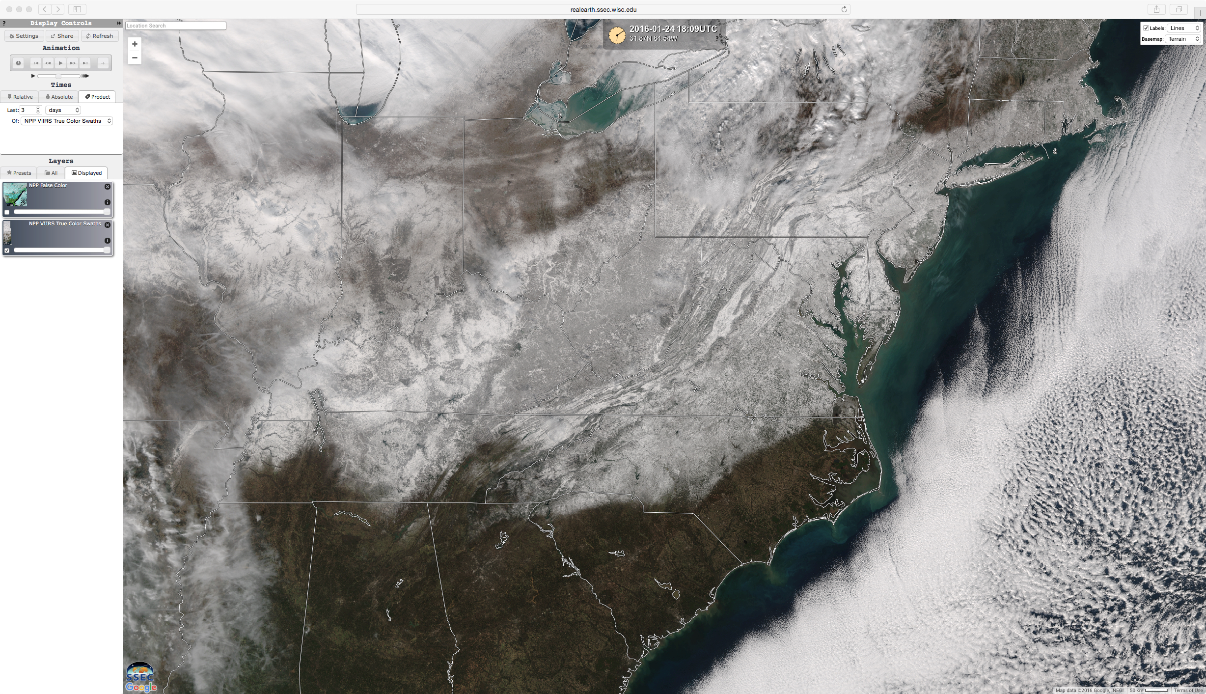
CIMSS VISIT Activities: The Virtual Institute for Satellite Integration Training (VISIT) lessons "TROugh of Warm air ALoft (TROWAL) Identification" (http://rammb.cira.colostate.edu/training/visit/training_sessions/trowal_identification/) and "NOAA/Cooperative Institute for Meteorological Satellite Studies (CIMSS) ProbSevere Product" (http://rammb.cira.colostate.edu/training/visit/training_sessions/noaa_cimss_probsevere_product/) were presented by S. Lindstrom on January 28 and 29, 2016. S. Lindstrom and S. Bachmeier participated in the VISIT Satellite Chat session held on January 27, discussing the Eastern United States Blizzard of 2016 (http://rammb.cira.colostate.edu/training/visit/satellite_chat/20160127). In addition, a wide variety of satellite images showing the development and aftermath of the "Historic Winter Storm Along the US East Coast" were posted on the CIMSS Satellite Blog (http://cimss.ssec.wisc.edu/goes/blog/archives/20550). (S. Lindstrom, CIMSS, 608-263-4425, S. Bachmeier, CIMSS, 608-263-3958)
 (Click image to enlarge)
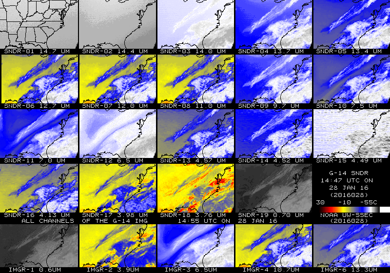
GOES-14 Again Sending Data: Geostationary Operational Environmental Satellite (GOES)-14, located at 105 West longitude, is once again sending experimental data. This is in support of Super Rapid Scan Operations for GOES-R (SRSOR) 1-minute imagery to begin on February 1, 2016. GOES-14 Sounder data are also being generated, emulating the GOES-East schedule. More SRSOR information on the daily schedules and image center points is available at http://cimss.ssec.wisc.edu/goes/srsor2016/GOES-14_SRSOR.html. Near real-time imagery from the GOES-14 sounder can be found at http://cimss.ssec.wisc.edu/goes/rt/viewdata.php?product=gw_all. (T. Schmit, E/RA2, 608-263-0291, tim.j.schmit@noaa.gov; J. Nelson, CIMSS, 608-263-6013)
 (Click image to enlarge)
VISITORS:
NEXT WEEK:
LOOKING AHEAD:
| Archived Weeklies Page | Submit a report item |