[ Archive ]
| CIMSS-NOAA Weekly Report
[ Archive ] |
IN THE PRESS:
ITEMS FOR THE ADMINISTRATOR:
ITEMS FOR THE ASSISTANT ADMINISTRATOR:
ITEMS FOR THE OFFICE DIRECTOR, STAR:
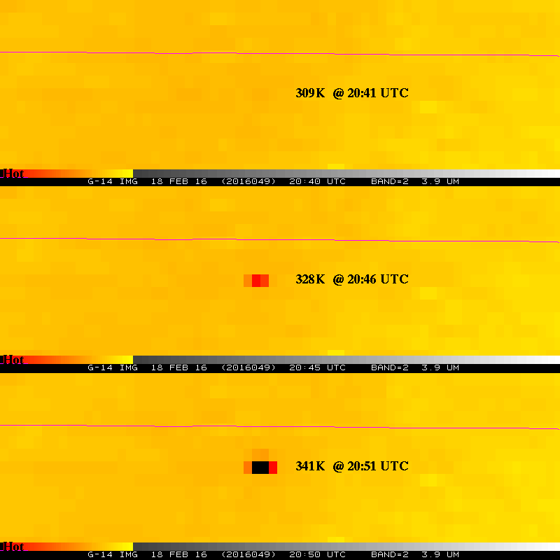
Unique Rapid Scan Observations: The February 2016 Geostationary Operational Environmental Satellite (GOES)-14 Super Rapid Scan Operations for GOES-R (SRSOR) imagery data collection campaign has been completed, which captured many interesting cases including convective snow, severe thunderstorms, wildfires, blowing dust, explosive east coast storms, volcanoes and gravity waves. These 1-minute data are being used to better prepare for the mesoscale mode on the Advanced Baseline Imager (ABI) and were used at a number of national centers, forecast offices and a field experiment. More information on the daily schedules and image center points is available at http://cimss.ssec.wisc.edu/goes/srsor2016/GOES-14_SRSOR.html. Animations, including CIMSS Satellite Blog entries, are available at http://cimss.ssec.wisc.edu/goes/blog/archives/category/goes-14. (T. Schmit, E/RA2, 608-263-0291, tim.j.schmit@noaa.gov; S. Bachmeier, CIMSS, 608-263-3958; M. Gunshor, CIMSS, S. Lindstrom, CIMSS)
 (Click image to enlarge)
Figure caption: Color-enhanced GOES-14 Imager 4 micrometer images showing a rapidly developing fire over northern Oklahoma during the afternoon of February 18, 2016. The top panel does not show the hot spot, while just five minutes later the brightness temperature increased almost 20K. Note that the current GOES Imager repeat time over the contiguous U.S. is between 15 and 30 minutes.
Paper Published on AVHRR Polar Pathfinder Climate Data Records: A paper titled "The AVHRR Polar Pathfinder Climate Data Records", by J. Key, X. Wang, Y. Liu, R. Dworak, and A. Letterly, was published in the journal Remote Sensing (2016, Remote Sens, 8(3), 167, doi:10.3390/rs8030167). This paper describes the Advanced Very High Resolution Radiometer (AVHRR) Polar Pathfinder (APP) dataset, which is a fundamental climate data record that provides channel reflectances and brightness temperatures, and the AVHRR Polar Pathfinder—Extended (APP-x) dataset, which is a thematic climate data record. (J. Key, E/RA2, 608-263-2605, jkey@ssec.wisc.edu)
ITEMS FOR THE DIVISION CHIEF, CoRP:
Cloud Algorithms Delivered to STAR AIT: The first version of the cloud base algorithm was delivered to the STAR Algorithm Implementation Team (AIT) this week. The algorithm was developed by colleagues at the Cooperative Institute for Research in the Atmosphere (CIRA) and the operational implementation was done at the Cooperative Institute for Meteorological Satellite Studies (CIMSS). Also included in this delivery to the AIT were updated versions of the cloud mask and cloud height algorithms. All of these algorithms are part of the NOAA Enterprise suite of algorithms and will be delivered by the AIT to NESDIS operations in April.(A. Heidinger, E/RA2, 608-263-6757, andrew.heidinger@noaa.gov, William Straka, CIMSS, wstraka@ssec.wisc.edu)
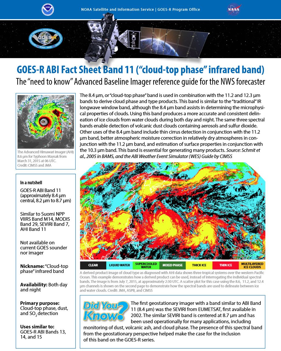
Key ABI Band Quick Information Sheets Developed: Several more Geostationary Operational Environmental Satellite (GOES) -R series Advanced Baseline Imager (ABI) band fact sheets have been developed and posted on the GOES-R website. These fact sheets include the “lower-level tropospheric water vapor" (6.9 um), "cloud-top phase" (8.4 um), “ozone" (9.6 um), "clean infrared longwave window" (10.3 um), and the "infrared longwave window" (11.2 um) bands. These 2-page summaries are meant to be quick references, covering some of the key information relevant to forecasters and others. This includes imagery, spectral information, uses and links for more information. The ABI band quick information (fact sheets) are posted at http://www.goes-r.gov/education/ABI-bands-quick-info.html. (T. Schmit, E/RA2, 608-263-0291, tim.j.schmit@noaa.gov; J. Gerth, CIMSS; M. Gunshor, CIMSS, 608-263-1146; Scott Bachmeier, CIMSS)
 (Click image to enlarge)
VISITORS:
NEXT WEEK:
LOOKING AHEAD:
| Archived Weeklies Page | Submit a report item |