 |
CIMSS-NOAA Weekly Report
[ Archive ] |
 |
CIMSS AND ASPB WEEKLY HIGHLIGHTS FOR THE WEEK ENDING APRIL 1, 2016
IN THE PRESS:
ITEMS FOR THE ADMINISTRATOR:
ITEMS FOR THE ASSISTANT ADMINISTRATOR:
ITEMS FOR THE OFFICE DIRECTOR, STAR:
CIMSS AWARDS: CIMSS Scientists Receive Awards: 1) Satellite pioneer Bill Smith, senior scientist at the Space Science and Engineering Center (SSEC) and first director of the Cooperative Institute for Meteorological Satellite Studies (CIMSS) received the 2016 Losey Atmospheric Sciences Award (http://www.ssec.wisc.edu/news/articles/8720); 2) Michael Pavolonis, physical scientist with NOAA's Advanced Satellite Products Branch has received the 2015 Earth Science and Applications Award from the American Astronautical Society "for developing cutting-edge methods to convert satellite data into actionable information for mitigating hazards caused by volcanic eruptions and severe convection;" 3) Jun Li, senior scientist with CIMSS, has been awarded the Distinguished Scientist prefix by the University of Wisconsin-Madison, a "title reserved for a small number of academic staff whose superlative accomplishments are evidenced by peer recognition." (J. Phillips, SSEC, 608-262-8164, B. Smith, 608-262-1905, M. Pavolonis, E/RA2, 608-263-9597, J. Li, CIMSS, 608-262-3755)
Support for 2016 Severe Weather Warning Operations: The ProbSevere model, which utilizes Numerical Weather Prediction (NWP), satellite, radar, and lightning data to determine the probability that a given developing thunderstorm will produce severe weather up to 60 minutes in the future, is supporting National Weather Service (NWS) severe weather warning operations. A total of 49 NWS Weather Forecast Offices (WFO’s) in the Eastern and Central Regions are utilizing the ProbSevere model in operations and will provide valuable feedback. ProbSevere has been shown to increase the median lead-time of severe weather warnings by 14 minutes, with the lead-time expected to grow in the next generation Geostationary Operational Environmental Satellite (GOES-R) era. Forecaster feedback from the Hazardous Weather Testbed (HWT) showed that 99% percent of forecasters would utilize ProbSevere in severe weather warning operations. The positive HWT feedback lead to the current WFO based experiment in the Eastern and Central NWS Regions. ProbSevere development is being lead by NOAA/NESDIS/STAR in close collaboration with the Cooperative Institute for Meteorological Satellite Studies (CIMSS). (M. Pavolonis, E/RA2, 608-263-9597, Mike.Pavolonis@noaa.gov, J. Cintineo, CIMSS, J. Sieglaff, CIMSS, S. Lindstrom, CIMSS)
ITEMS FOR THE DIVISION CHIEF, CoRP:
WMO Committee: Jim Kossin (NOAA/NCEI) has accepted a position on the World Meteorological Organization (WMO) Commission for Climatology (CCl) ad-hoc Weather and Climate Extremes evaluation committee. (J. Kossin, NOAA/NCEI, 608-265-5356)
Lead Authorship on USGCRP Report: Jim Kossin (NOAA/NCEI) has accepted a position as a Lead Author on a U.S. Global Change Research Program (USGCRP) Climate Science Special Report (CSSR). (J. Kossin, NOAA/NCEI, 608-265-5356)
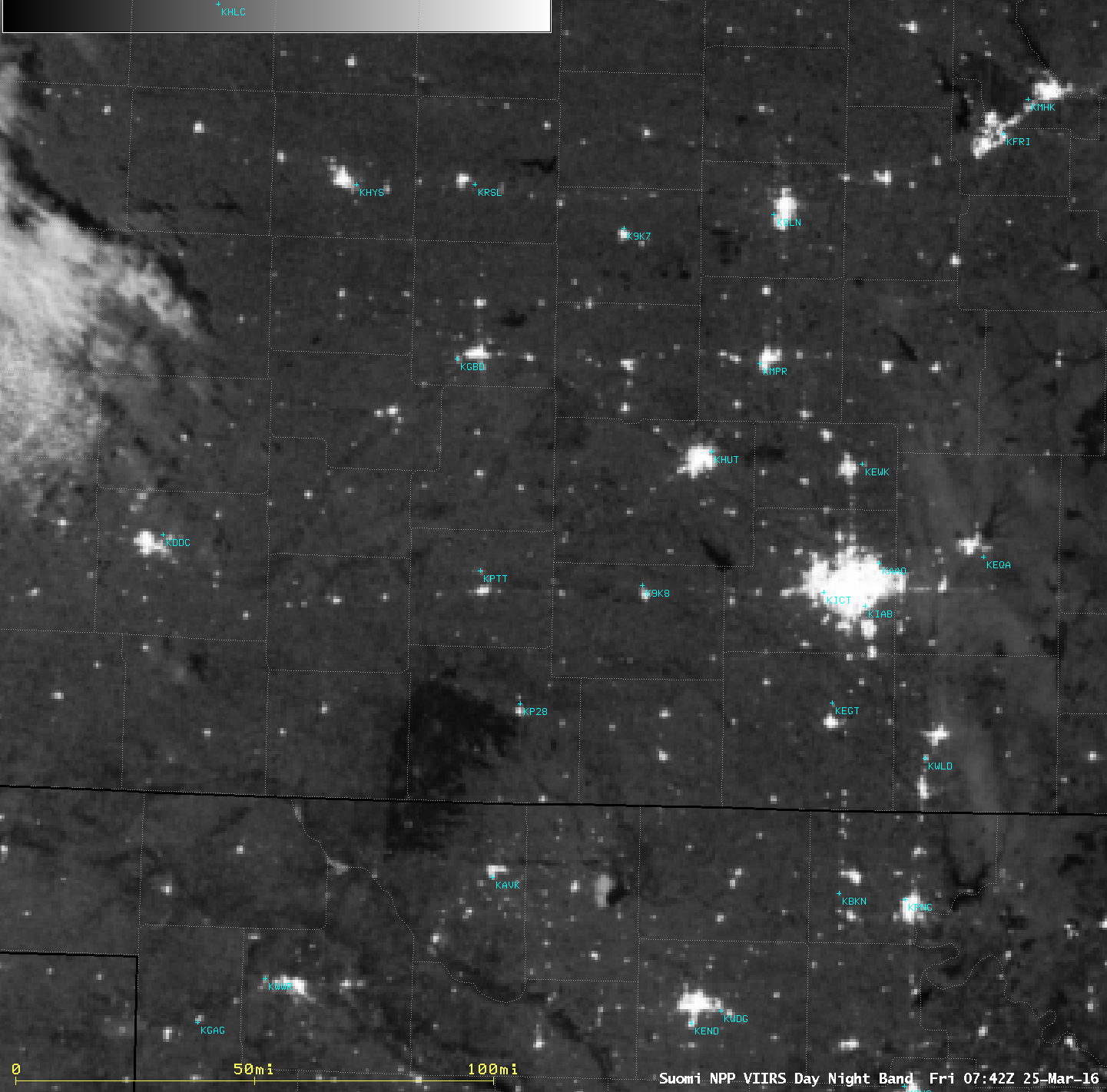
Satellite Images of Largest Wildfire on Record in Kansas: A grass fire began in northern Oklahoma late in the day on March 22, 2016 and rapidly spread into southern Kansas during the overnight hours and continued during the day on March 23. The fire burned 397,420 acres in the state of Kansas, making it the largest wildfire on record in that state. A variety of satellite images of the fire event are posted on the Cooperative Institute for Meteorological Satellite Studies (CIMSS) Satellite Blog (http://cimss.ssec.wisc.edu/goes/blog/archives/20977). (S. Bachmeier, CIMSS, 608-263-3958)
 (Click image to enlarge)
Figure caption: With ample illumination from the moon, the contrast between the dark Anderson Creek fire burn scar and the lighter surrounding grassland was very apparent on a Suomi NPP VIIRS Day/Night Band (0.7 µm) image at 0742 UTC or 2:42 AM local time.
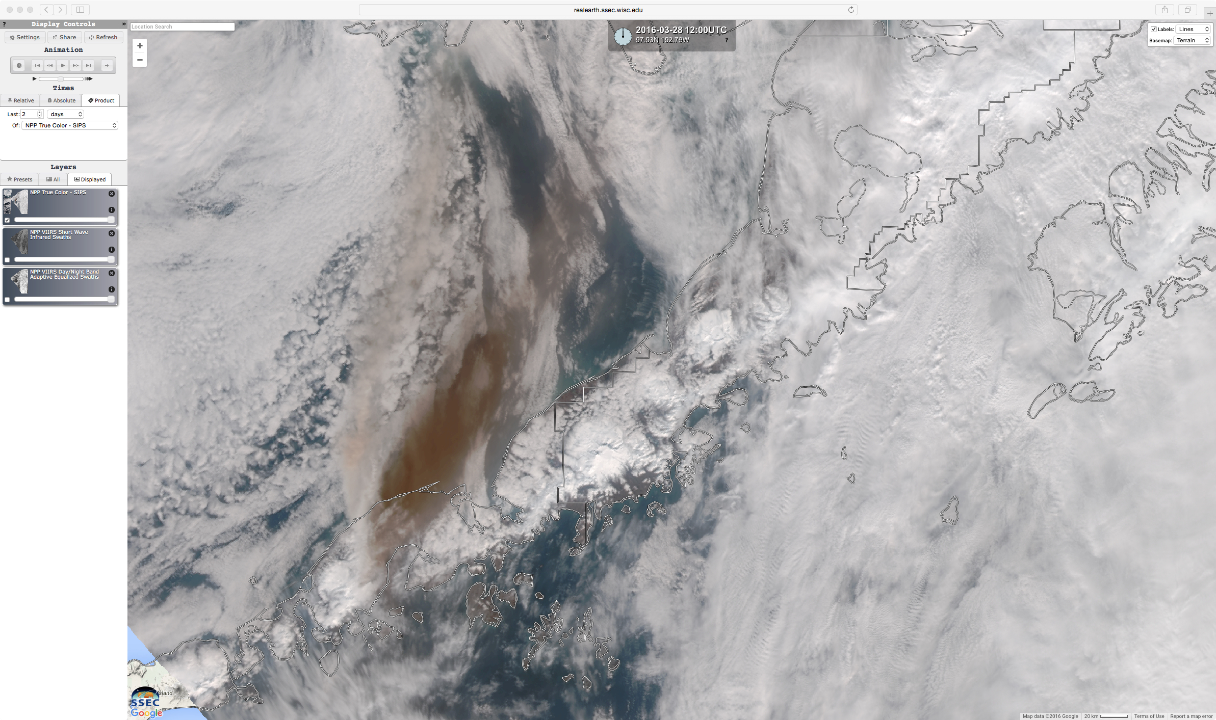
Satellite Images of Mount Pavlof Volcano Eruption in Alaska: A major eruption of the Mount Pavlof volcano on the Alaska Peninsula began on March 28, 2016. The volcanic ash cloud rose to heights of at least 37,000 feet, and quickly moved northeastward over the interior of Alaska forcing a number of cancelled flights. A variety of satellite images of the event are posted on the Cooperative Institute for Meteorological Satellite Studies (CIMSS) Satellite Blog (http://cimss.ssec.wisc.edu/goes/blog/archives/21004). (S. Bachmeier, CIMSS, 608-263-3958)
 (Click image to enlarge)
Figure caption: Suomi NPP VIIRS true-color image showing the brown-colored ash cloud from the eruption of the Mount Pavlof volcano on March 28, 2016.
Support for Operational Volcanic Ash Cloud Tracking in Alaska: During the week of March 27, 2016, volcanic ash emissions from Pavlof Volcano, located on the Alaska Peninsula, disrupted air travel in parts of Alaska. The quantitative and qualitative satellite-based volcanic cloud products developed by NOAA/NESDIS/STAR, in collaboration with the Cooperative Institute for Meteorological Satellite Studies (CIMSS), supported operational efforts to track and characterize the hazardous Pavlof ash clouds. The Anchorage Volcanic Ash Advisory Center utilized near real-time volcanic cloud imagery, derived from Japanese Meteorological Agency (JMA) Himawari-8 geostationary satellite measurements, and quantitative products derived from low earth orbit sensors, to assist in operational decision-making. The near real-time NOAA/NESDIS/STAR/CIMSS volcanic cloud products are available at http://volcano.ssec.wisc.edu/imagery/view/. (M. Pavolonis, E/RA2, 608-263-9597, Mike.Pavolonis@noaa.gov, J. Sieglaff, CIMSS)
STAR JPSS Enterprise Algorithms Workshop: Andy Heidinger and Jeff Key participated (remotely) in the STAR JPSS Enterprise Algorithms Workshop, March 30-31, 2016. The meeting was held in College Park, MD. The purpose of the meeting was to discuss the status of the Enterprise algorithms. Heidinger presented the cloud products; Key presented the cryosphere and polar winds products. (J. Key, E/RA2, 608-263-2605, jkey@ssec.wisc.edu; A. Heidinger, E/RA2, 608-263-6757, andrew.heidinger@noaa.gov)
VISITORS:
NEXT WEEK:
LOOKING AHEAD: