[ Archive ]
| CIMSS-NOAA Weekly Report
[ Archive ] |
IN THE PRESS:
ITEMS FOR THE ADMINISTRATOR:
ITEMS FOR THE ASSISTANT ADMINISTRATOR:
ITEMS FOR THE OFFICE DIRECTOR, STAR:
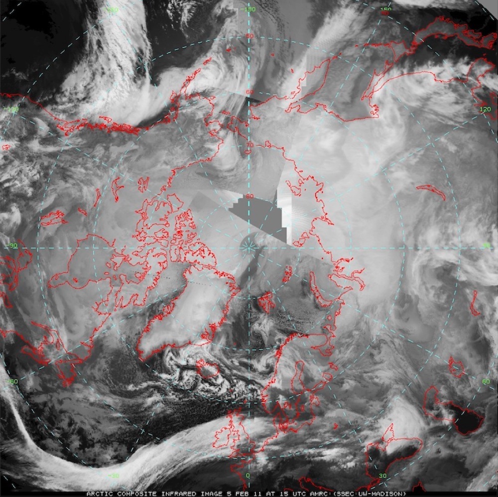
Arctic Composite Imagery Approved for Operations: On April 20, 2016, the NOAA/NESDIS Satellite Products and Services Review Board (SPSRB) approved the Arctic Composite Imagery product for operations. The product provides an hourly mosaic of geostationary and polar-orbiting satellite data over the Arctic region, which can be used to examine the evolution of weather phenomena through time series of images animations. It will be officially operational in May. (M. Lazzara, SSEC; J. Key, E/RA2, 608-263-2605, jkey@ssec.wisc.edu)
 (Click image to enlarge)
Figure caption: An example of the Arctic composite imagery product.
CIMSS Participation at IASI 2016 Conference: Dave Santek, Ralph Petersen, Liam Gumley, and Jessica Gartzke of the Cooperative Institute for Meteorological Satellite Studies (CIMSS) attended the 4th IASI (Infrared Atmospheric Sounding Interferometer) Conference in Juan-les-Pins, France from 11 – 15 April 2016. This conference is a forum to share and review the latest results from the operational and scientific use of nearly a decade of hyperspectral observations with IASI instruments on the Metop satellites. R. Petersen presented “Increasing the utility of real-time IASI moisture and temperature soundings In very-short-range forecasting”, L. Gumley “Real-Time Access to Advanced Sounder Data over North America from the NOAA Direct Broadcast Network”, J. Gartzke “Convective Available Potential Energy (CAPE) derived from Hyperspectral Infrared Satellite Sounders”, and D. Santek’s poster “Satellite-derived 3D Winds: Global Model Impact Studies for Current and Future Observing Systems” was awarded second place in the poster competition for a novel use of IASI data. (D. Santek, CIMSS/SSEC, 608-263-7410; R. Petersen, ralph.petersen@ssec.wisc.edu)
International Radiation Symposium 2016: Yinghui Liu attended the International Radiation Symposium 2016 in Auckland, New Zealand April 16-22, 2016. The International Radiation Symposium provides a forum for the presentation of the best and latest research in Atmospheric Radiation in its many forms. Yinghui Liu presented a talk titled “Assessment of Capability of Depicting Cloud Amount Anomalies from ERA-Interim and MERRA Using MODIS”. (Y. Liu, CIMSS, 608-265-8620)
ITEMS FOR THE DIVISION CHIEF, CoRP:
Manucript on 6.7 μm band water vapor information analysis accepted for publication: A manuscript titled "Geostationary satellite-based 6.7 μm band best water vapor information layer analysis over the Tibetan Plateau", has been accepted for publication in the Journal of Geophysical Research - Atmospheres. This paper shows that surface characteristics over the Tibetan Plateau have a significant influence on the best water vapor information layer (BWIL) of 6.7 μm. For example, topographic elevation, colder skin temperature and lower surface emissivity tend to lift the altitude of the BWIL, decrease its magnitude, and narrow the half-width range. The study also indicates that the altitude of the BWIL reaches the highest in summer and the lowest in winter. The authors are Di Di (China Meteorological Administration - CMA), Yufei Ai (Cooperative Institute for Meteorological Satellite Studies - CIMSS, and Peking University - PKU), and Jun Li (CIMSS). (Jun Li, Jun.Li@ssec.wisc.edu, 608-262-3755). (Click image to enlarge)
VISITORS:
NEXT WEEK:
LOOKING AHEAD:
| Archived Weeklies Page | Submit a report item |