[ Archive ]
| CIMSS-NOAA Weekly Report
[ Archive ] |
IN THE PRESS:
Through the Atmosphere: From Seasoned Scientists to Research Interns: Scientists from the Space Science and Engineering Center (SSEC) and the Cooperative Institute for Meteorological Satellite Studies (CIMSS) work as a community to learn more about Earth's atmosphere, applying that knowledge to protect and improve our lives. Meet a few of them in the Winter/Spring 2016 edition of SSEC's Through the Atmosphere: "From Seasoned Scientists to Research Interns" at http://www.ssec.wisc.edu/news/articles/8794. (J. Phillips, SSEC, 608-262-8164, S. Witman, SSEC, L. Avila, CIMSS, B. Bellon, SSEC)
 (Click image to enlarge)
ITEMS FOR THE ADMINISTRATOR:
ITEMS FOR THE ASSISTANT ADMINISTRATOR:
ITEMS FOR THE OFFICE DIRECTOR, STAR:
GOES-R Training in Mexico City: Scott Lindstrom (CIMSS) accompanied Martin Medina (NESDIS International and Interagency Affairs Division) and Sandra Cauffman (GOES-R Deputy System Program Director) to SMN (Servicio Meteorológico Nacional)/Conaqua in Mexico City, D.F., to provide information on the GOES-R GLM (Geostationary Lightning Mapper; 1 75-minute lecture) and ABI (Advanced Baseline Imager; a 90-minute lecture and a 45-minute lecture) on 2-3 May 2016. Attendees included Forecasters, Managers, and University Professors. (S. Lindstrom, CIMSS, 608-263-4425)
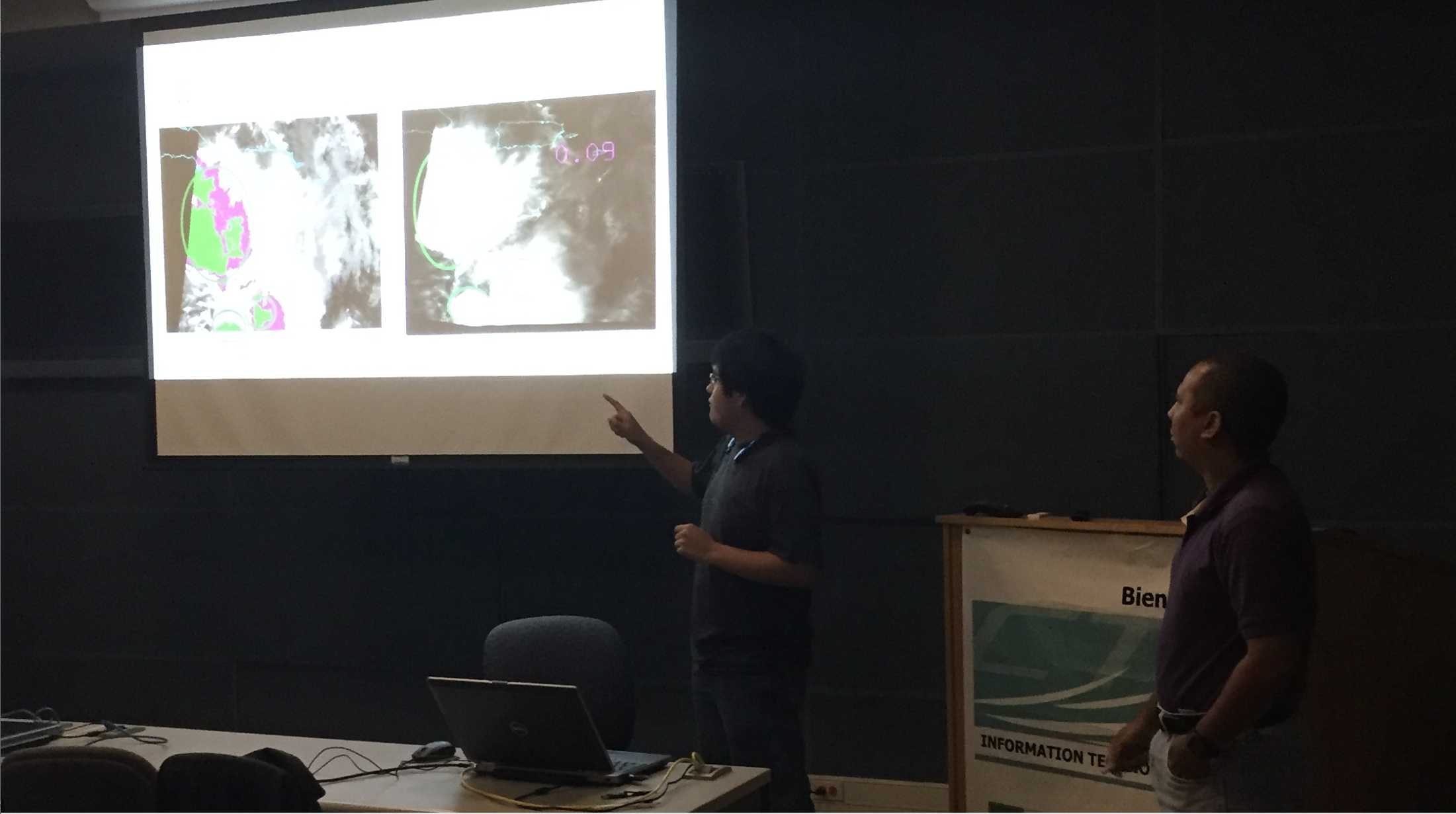
Puerto Rico Direct Broadcast Applications Workshop: Cooperative Institute for Meteorological Satellite Studies (CIMSS) personnel Kathleen Strabala, Liam Gumley and Jessica Braun taught a Direct Broadcast Polar Orbiter Applications Workshop at the University of Puerto Rico in Mayagüez, 26-29 April 2016, in support of the newly installed NOAA sponsored X/L band antenna. Participants included remote sensing image processing, geology and marine science faculty and graduate students. The course focused on the multitude of polar orbiter satellites and sensor data that can be acquired by direct broadcast in real time and the data and products used for environmental applications using free software including the NOAA Community Satellite Processing Package (CSPP), and the NASA International MODIS/AIR Processing Package (IMAPP). The workshop consisted of morning lectures and afternoon hands-on lab sessions investigating local data and products. The course concludes with students presenting results from an investigation into a topic of their choice using local real time or case study data. (K. Strabala, CIMSS, 608-263-8752)
 (Click image to enlarge)
Figure caption: Students presenting results from an investigation of the relationship between 13.9 and 11 micron brightness temperature differences and precipitation over Hurricane Bertha, 2 August 2014, during the Puerto Rico Direct Broadcast Applications Workshop in Mayagüez.
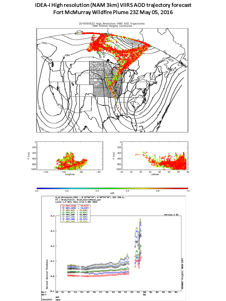
High resolution IDEA-I VIIRS AOD forecast of Fort McMurray Wildfire Plume: New high resolution Infusing satellite Data into Environmental Applications – International (IDEA-I) smoke trajectory forecasts are shown to accurately predict transport of smoke over Madison, WI that originated from wildfires burning near Fort McMurray in northeastern Alberta. The IDEA-I high resolution smoke trajectory forecasts use the North American Model (NAM) 3 km resolution forecasts to predict trajectories initialized with aerosol optical depth (AOD) retrievals from the Visible Infrared Imaging Radiometer Suite (VIIRS) instrument on the Joint Polar Satellite System (JPSS) Suomi National Polar-orbiting Partnership (SNPP). AErosol RObotic NETwork (AERONET) AOD measurements at the University of Wisconsin Space Science and Engineering Center (SSEC) confirms the arrival of the smoke plume over Madison WI at 23Z on May 05, 2016. Development of the high resolution VIIRS AOD trajectories is supported by the JPSS Proving Ground and Risk Reduction Program and is part of the JPSS Fire and Smoke Initiative (R.B. Pierce, E/RA2, 608-890-1892, brad.pierce@noaa.gov)
 (Click image to enlarge)
ITEMS FOR THE DIVISION CHIEF, CoRP:
Presentation at Bi-Lateral Workshop with Environment Canada: Jordan Gerth, of the Cooperative Institute for Meteorological Satellite Studies, participated in the 2016 NOAA-Environment Canada (EC) Bi-Lateral Marine Focus Area Workshop from 3-5 May 2016, at the NOAA Great Lakes Environmental Research Laboratory (GLERL) in Ann Arbor, Michigan. Meeting attendees were from NOAA, particularly the National Weather Service (NWS), EC, and the United States Coast Guard. As part of the workshop, he gave a presentation on marine and arctic applications of new generation weather satellite imagery. The attendees enjoyed the presentation and were interested in specific plans for training operational meteorologists on marine and arctic applications of the imagery. (J. Gerth, CIMSS, 608-263-4942)
Satellite Images of Fort McMurray, Alberta Wildfire: A variety of satellite images of the large wildfire at Fort McMurray, Alberta were posted on the Pyrocumulonimbus (PyroCb) Blog (http://pyrocb.ssec.wisc.edu/archives/1572), including 1-minute super rapid scan images from the Geostationary Operational Environmental Satellite (GOES)-14. The fire forced the evacuation of all residents of the city of Fort McMurray on May 3, 2016 (the largest fire-related evacuation on record for the province of Alberta). (S. Bachmeier, CIMSS, 608-263-3958, W. Straka, SSEC)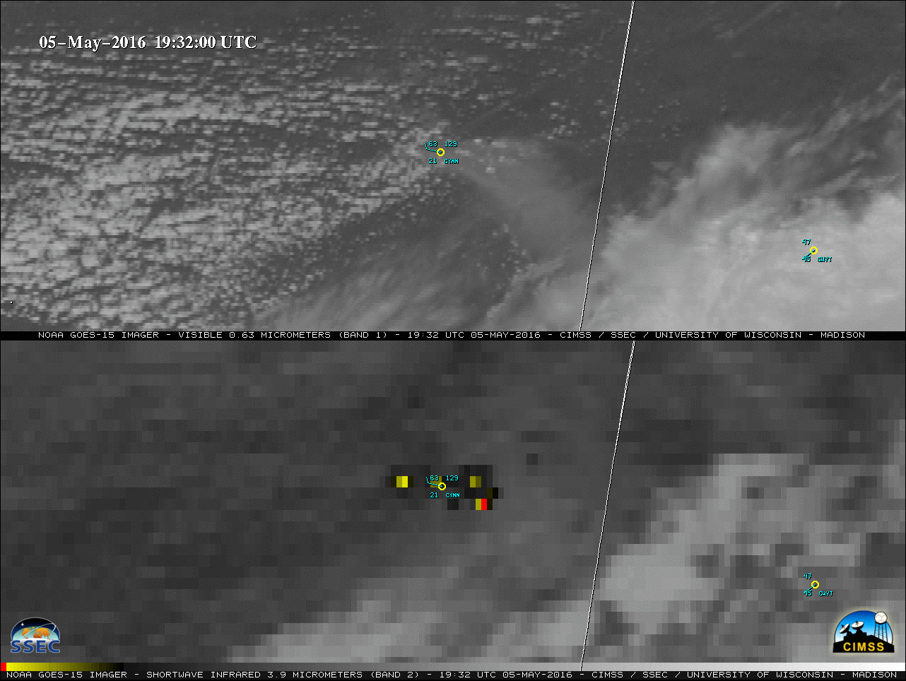 (Click image to enlarge)
VISITORS:
NEXT WEEK:
LOOKING AHEAD:
| Archived Weeklies Page | Submit a report item |