 |
CIMSS-NOAA Weekly Report
[ Archive ] |
 |
CIMSS AND ASPB WEEKLY HIGHLIGHTS FOR THE WEEK ENDING JULY 8, 2016
IN THE PRESS:
ITEMS FOR THE ADMINISTRATOR:
ITEMS FOR THE ASSISTANT ADMINISTRATOR:
ITEMS FOR THE OFFICE DIRECTOR, STAR:
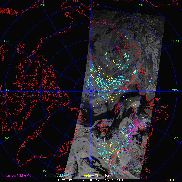
New Shortwave Infrared Polar Winds: Polar winds from the Moderate Resolution Imaging Spectroradiometer (MODIS) 2.1 𝜇m band are now routinely produced at the Cooperative Institute for Meteorological Satellite Studies (CIMSS) for the Arctic and Antarctic (http://stratus.ssec.wisc.edu/products/rtpolarwinds/, labelled as “Terra-SWIR” and “Aqua-SWIR”). This experimental product was created because clouds, which are tracked to derive winds, are notoriously difficult to detect over snow and ice due to the similarities between their temperature and reflectance properties and those of the underlying surface, resulting in less well-defined targets for tracking. In the shortwave infrared (SWIR), however, the scattering properties of liquid clouds and snow/ice are significantly different, and therefore the contrast between low clouds and the surface is large. In theory, SWIR data will provide more good features for cloud tracking and atmospheric motion vector derivation during the “daytime”, especially for low clouds. This work will be extended to the VIIRS 1.6 𝜇m band in the near future. We expect that some numerical weather prediction centers will begin testing the impact of the SWIR polar winds in the near future. (J. Key, E/RA2, 608-263-2605, jkey@ssec.wisc.edu; D. Santek, CIMSS, 608-263-7410; R. Dworak, CIMSS, 608-265-8620)
 (Click image to enlarge)
Figure caption: Winds over the Arctic based on cloud tracking in a shortwave infrared (SWIR) band on MODIS.
ITEMS FOR THE DIVISION CHIEF, CoRP:
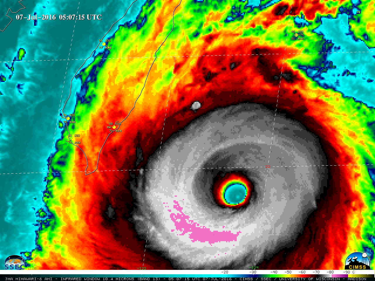
Satellite Imges of Super Typhoon Nepartak: Satellite images of Category 5 Super Typhoon Nepartak were posted on the Cooperative Institute for Meteorological Satellite Studies (CIMSS) Satellite Blog (http://cimss.ssec.wisc.edu/goes/blog/archives/21552), which included examples of 2.5-minute interval rapid scan Himawari-8 visible and infrared. Nepartak was the first tropical cyclone of the 2016 season in the West Pacific Basin, and rapidly intensified to reach Category 5 intensity before making landfall on the island of Taiwan on July 7, 2016. (S. Bachmeier, CIMSS, 608-263-3958)
 (Click image to enlarge)
Figure caption: Himawari-8 Infrared (10.4 µm) image of Super Typhoon Nepartak at 0507 UTC on July 7, 2016.
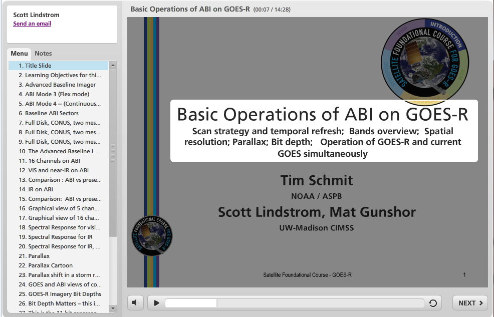
GOES-R Training Modules Produced and Uploaded to the LMS: Four Learning Modules produced by the Cooperative Institute for Meteorological Satellite Studies (CIMSS) that are part of the Office of the Chief Learning Officer (OCLO) Satellite Foundational Course for Geostationary Operational Environmental Satellite (GOES)-R (SatFC-G) have been uploaded to the Weather Service LMS (Learning Management System). The topics (and lengths) of these modules are Basic Operations of GOES-R (15 minutes), Multi-Channel Interpretations of GOES-R Data (30 minutes), Baseline Products: Fire Detection (10 Minutes) and Baseline Products: Volcanic Ash (10 Minutes). Subject Matter Experts (SME) and reviewers included ASPB members. These modules are part of the Day-1 GOES-R Readiness Training designed to familiarize National Weather Service forecasters with the new capabilities associated with GOES-R. (S. Lindstrom, CIMSS, 608-263-4425; T. Schmit, E/RA2, 608-263-0291, tim.j.schmit@noaa.gov; M. Pavolonis, E/RA2, 608-263-9597, michael.pavolonis@noaa.gov; M. Gunshor, CIMSS, 608-263-1146; C. Schmidt, CIMSS, 608-262-7973; C. Calvert, CIMSS; J. Gerth, CIMSS)
 (Click image to enlarge)
Figure caption: Screen Capture of Title Slide of Basic Operations of GOES-R Training now in LMS.
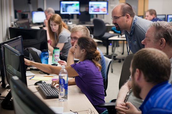
SSEC News Highlights HWT, GOES-3, Data Rescue Initiatives: Recent news stories from the Space Science and Engineering Center (SSEC) and the Cooperative Institute for Meteorological Satellite Studies (CIMSS) highlight participation in the NOAA Hazardous Weather Testbed (HWT), GOES-3 decommissioning, and new data rescue initiatives:
Strong showing by SSEC scientists at annual severe weather experiment: https://www.ssec.wisc.edu/news/articles/8965; GOES-3 satellite to be decommissioned: https://www.ssec.wisc.edu/news/articles/8929; Data ‘rescue’ project blends analog, digital technologies: https://www.ssec.wisc.edu/news/articles/8980. (J. Phillips, SSEC, 608-262-8164, S. Witman, SSEC, 608-263-4206)
 (Click image to enlarge)
Figure caption: SSEC/CIMSS scientist Justin Sieglaff at the 2016 Hazardous Weather Testbed (HWT) Spring Experiment. Credit: NOAA.
JPSS-CUNY Outreach Presentation on the Arctic: Jeff Key gave a (remote) presentation as part of the City University of New York (CUNY) IMSG-JPSS collaborative educational outreach program. A number of CUNY graduate students are stationed at the IMSG facility in College Park, MD for two months. Key's presentation focused on the use of satellites for monitoring Arctic climate, highlighting the variety of NOAA's cryosphere products. (J. Key, E/RA2, 608-263-2605, jkey@ssec.wisc.edu)
VISITORS:
NEXT WEEK:
LOOKING AHEAD: