[ Archive ]
| CIMSS-NOAA Weekly Report [ Archive ] |
ASPB AND CIMSS WEEKLY HIGHLIGHTS FOR THE WEEK ENDING AUGUST 12, 2016
IN THE PRESS:
ITEMS FOR THE ADMINISTRATOR:
ITEMS FOR THE ASSISTANT ADMINISTRATOR:
ITEMS FOR THE OFFICE DIRECTOR, STAR:
ASPB and CIMSS Participation in the STAR JPSS Annual Meeting: Several STAR scientists from the Advanced Satellite Products Branch (ASPB) participated in the 2016 STAR JPSS Annual Meeting held in National Center for Weather and Climate Predication (NCWCP). Jeff Key and Andrew Heidinger led the Cryosphere and Cloud Sessions and gave multiple presentations. Mike Pavolonis and Brad Pierce participated remotely in the Trace Gas Session. Several scientists from the Cooperative Institute for Meteorological Satellite Studies (CIMSS) also attended. The CIMSS contingent included Tony Wimmers, Dave Tobin, Scott Mindock and Wayne Feltz. The meeting serves as programmatic review of all of STAR's activities including sensor calibration, product generation and user interactions. (A.Heidinger, ERA@, 608-263-6757, andrew.heidinger@noaa.gov)
ITEMS FOR THE DIVISION CHIEF, CoRP:
Satellite presentation to Native American students at BIA sponsored course: Bob Rabin (NOAA/National Severe Storms Lab) presented hands-on learning activities on measuring surface and cloud top temperature from satellites, and on the detection of wild fires. This included the use of interactive web tools with real-time GOES satellite imagery, and hand held infrared thermometers. The learning activity was part of a Bureau of Indian Affairs (BIA) sponsored Water Technicians Course at the University of Arizona, Tucson AZ, attended by 32 students from 18 difference tribes. (R. Rabin, NOAA/NSSL and CIMSS, 608-264-5325/405-366-0583)
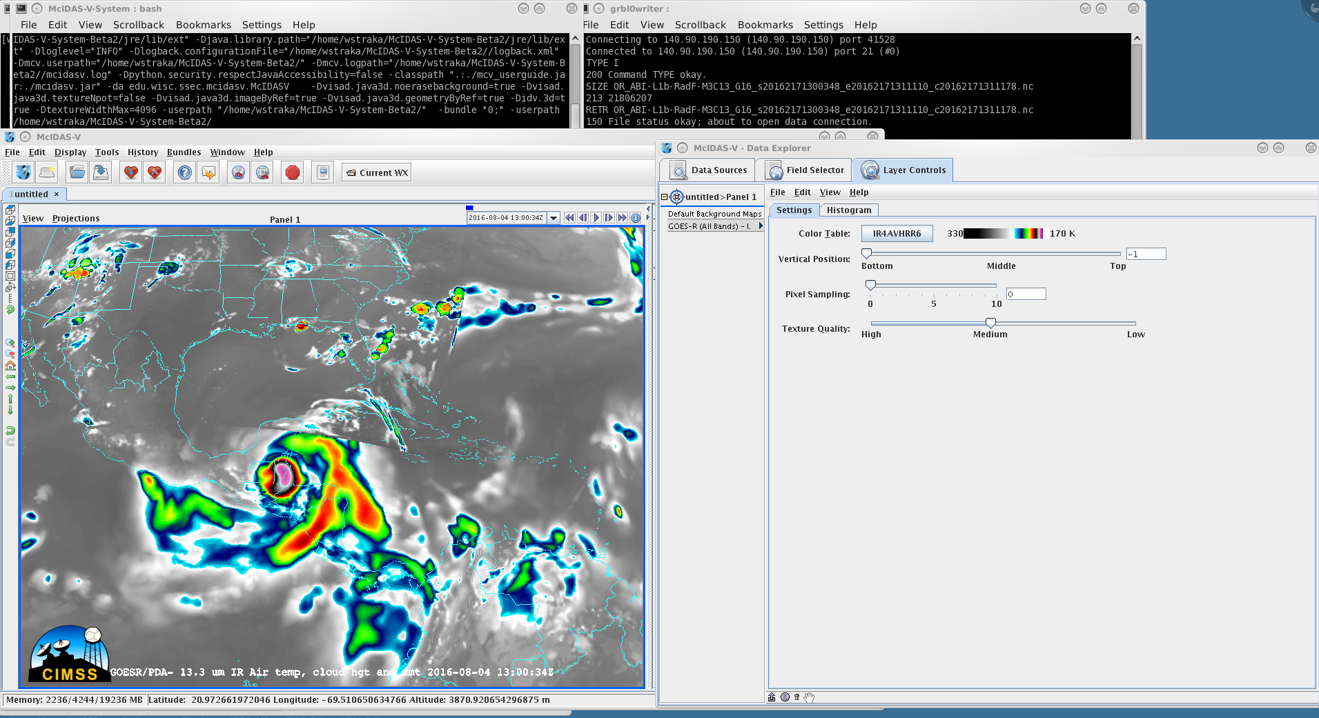
DOE-4 L1b and L2 analysis at CIMSS: Quasi-near realtime simulated Geostationary Operational Environmental Satellite (GOES)-R Advanced Baseline Imager (ABI) imagery and products have been flowing via the Environmental Satellite Product and Distribution System (ESPDS) to the Cooperative Institute for Meteorological Satellite Studies (CIMSS) as part of the GOES-R Data Operations Exercise (DOE)-4. As part of DOE-4, teams have demonstrated their ability to read in and visualize the experimental data through programs such as McIDAS (Man computer Interactive Data Access System)-V. (W. Straka III, CIMSS, 608-262-5128;T. Schmit, tim.j.schmit@noaa.gov, E/RA2, 608 263-0291;D. Santek, CIMSS, 608-263-7410)
 (Click image to enlarge)
Figure caption: A screen capture showing Hurricane Earl in the GOES-R ABI L1b Band 16 data download from ESPDS at CIMSS displayed in McIDAS-V.
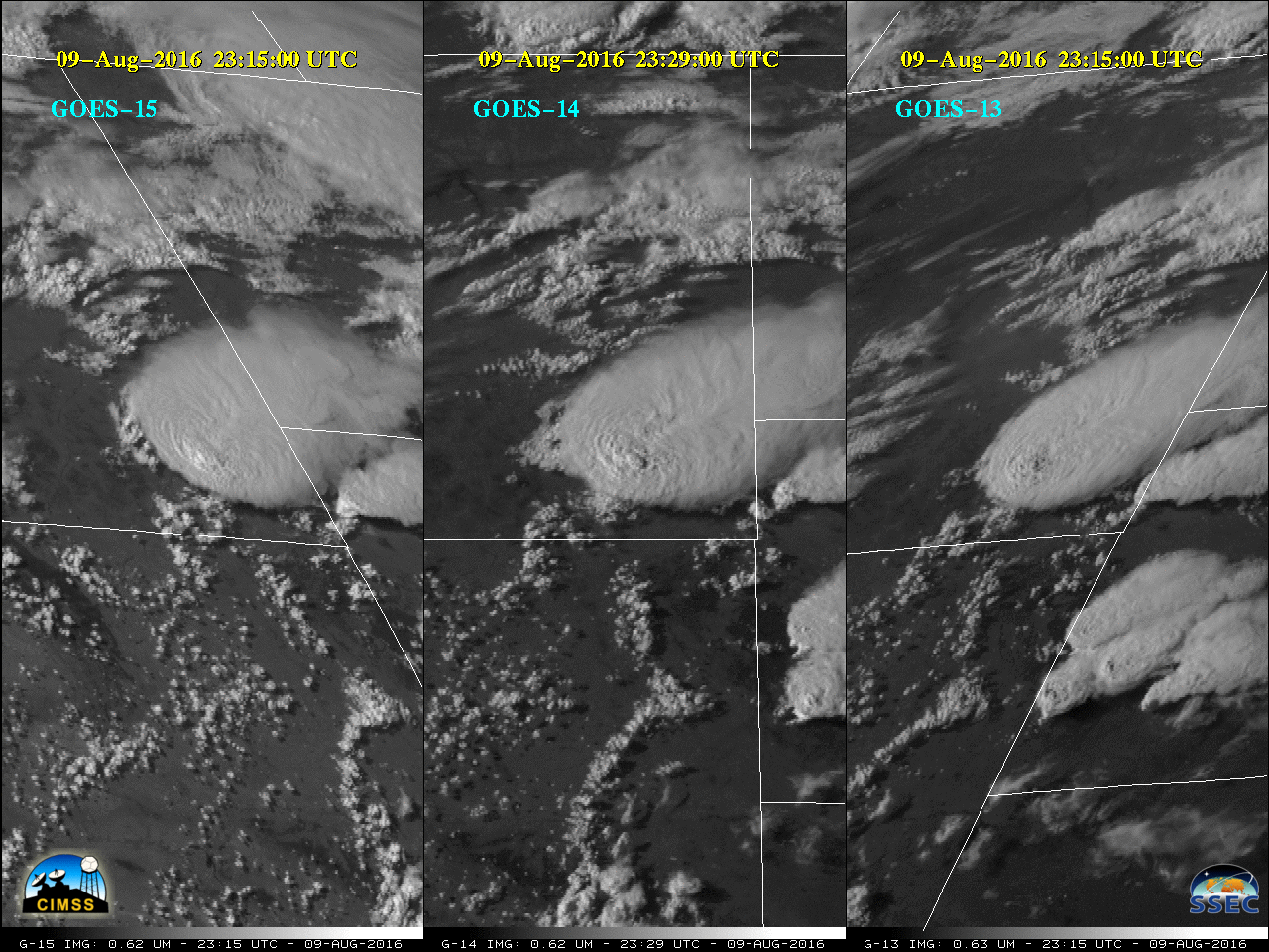
GOES-14 1-min Super Rapid Scan: The August 2016 Super Rapid Scan Operations for GOES-R (SRSOR) data collection from Geostationary Operational Environmental Satellite (GOES)-14 began on August 9, 2016. The SRSOR data are being used operationally by the NWS - some of their comments include: "Perfect timing! We've got the 1-min imagery up on our situational awareness displays. Really great to have it today" (Great Falls, MT), "The SRSOR data no doubt helped us provide a great service to our customers" (Billings, MT) and "Impressive storm with overshooting top in Carter county, MT! 1-min SSEC SRSOR Vis Sat" (Aberdeen, SD). This supercell thunderstorm case in Montana was especially noteworthy since the storms formed in a region of limited radar coverage, producing hail as large as 4 inches. More information and animations are available at at http://cimss.ssec.wisc.edu/goes/blog/archives/category/goes-14. (T. Schmit, E/RA2, 608-263-0291, tim.j.schmit@noaa.gov; S. Bachmeier, CIMSS, 608-263-3958; S. Lindstrom, CIMSS)
 (Click image to enlarge)
Figure caption: The view from three GOES (-15, -14 and -13) of a supercell thunderstorm in southeast Montana on August 9, 2016. These visible images are in their native satellite projections.
VISITORS:
NEXT WEEK:
LOOKING AHEAD:
| Archived Weeklies Page | Submit a report item |