[ Archive ]
| CIMSS-NOAA Weekly Report [ Archive ] |
ASPB AND CIMSS WEEKLY HIGHLIGHTS FOR THE WEEK ENDING SEPTEMBER 2, 2016
IN THE PRESS:
ITEMS FOR THE ADMINISTRATOR:
ITEMS FOR THE ASSISTANT ADMINISTRATOR:
ITEMS FOR THE OFFICE DIRECTOR, STAR:
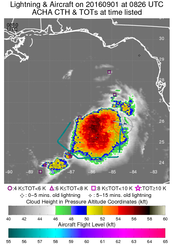
Support for Global Hawk Unmanned Missions into Hermine: The unmanned NASA Global Hawk high-altitude aircraft is flying missions into Tropical Cyclone Hermine as part of the NOAA SHOUT (Sensing Hazards with Operational Unmanned Technology) project. The Cooperative Institute for Meteorological Satellite Studies (CIMSS) is providing real-time satellite-derived product support for hazard avoidance and mission tracking. The CIMSS Tropical Cyclone (TC) Group has developed tailored GOES products such as Tropical Overshooting Tops, and provides access to cloud top heights derived from the GOES-R Algorithm Working Group Cloud Height Algorithm (ACHA) developed by the Advanced Satellite Products Branch. These products are being used extensively to navigate the Global Hawk through active convection and to dropsonde launch locations. The data are being transmitted in real time to be assimilated into numerical models. Several members of the CIMSS TC group are also serving as mission scientists and forecasters for the field project which extends through September. (C. Velden, CIMSS, 608-262-9168, S. Griffin, CIMSS, 608-262-0988, D. Herndon, CIMSS, 608-262-6741, T. Olander, CIMSS, 608-265-8005, A. Heidinger, E/RA2, 608-263-6757, S. Wanzong, CIMSS, 608-263-1950).
 (Click image to enlarge)
Figure caption: Track of the Global Hawk as it flies a mission during TS Hermine on 1 Sept. 2016. The track was deviated around the active convection as the associated GOES-derived cloud top heights indicated a potential hazard at the flight level of the aircraft.
CLAVR-x Update Delivered to OSPO: The current version of the Clouds from AVHRR Extended (CLAVR-x) Processing System was delivered to the Office of Satellite Products and Operations (OSPO) this week. CLAVR-x currently runs on older computers that OSPO would like to retire. This update will allow OSPO is run CLAVR-x on computers running Linux. This update would provide NESDIS customers the products from the same versions of the many of the NOAA Enterprise Algorithms that will be operational on the Visible Infrared Imaging Radiometer Suite (VIIRS) data in two months. In addition, this version of CLAVR-x is identical to the one being provided to the direct broadcast community via the Community Satellite Processing Package (CSPP). CLAVR-x should continue to provide products from the Advanced Very High Resolution Radiometer (AVHRR) throughout 2017. At some point in the future, CLAVR-x will be replaced by the NOAA Enterprise Processing System. (A. Heidinger, E/RA2, 608-263-6757, andrew.heidinger@noaa.gov, William Straka III, CIMSS, wstraka@ssec.wisc.edu)
GOES-14 Rapid Scan Data: Invest 99-L: The Atlantic Ocean tropical wave "Invest 99-L" became the most sampled tropical wave ever, given four straight days of 1-minute GOES-14 data. The animation is both on the CIMSS Satellite Blog (http://cimss.ssec.wisc.edu/goes/blog/archives/21788) and YouTube (http://cimss.ssec.wisc.edu/goes/srsor2016/YouTube_99L.html). The National Hurricane Center reported the observations were "...very useful for tracking low clouds to help determine if the system has a closed circulation. It was also useful for monitoring the new convection that is trying to develop south of the exposed center". These observations may be the last 1-min GOES-14 imagery, due to the upcoming launch of GOES-R with it's mesoscale mode of operations. (T. Schmit, E/RA2, 608-263-0291, tim.j.schmit@noaa.gov; S. Bachmeier, CIMSS, 608-263-3958; S. Lindstrom, CIMSS; SSEC Data Center)
ITEMS FOR THE DIVISION CHIEF, CoRP:
CIMSS in Alaska to Support Direct Broadcast Users: Cooperative Institute for Meteorological Satellite Studies (CIMSS) personnel, Kathy Strabala, Jordan Gerth and David Hoese, traveled to Anchorage and Fairbanks, Alaska to work with the Geographic Information Network of Alaska (GINA) team that supports users of polar orbiter satellite data in their state. GINA uses many of the Community Satellite Processing Package (CSPP) science software suites and supplies users with near-real-time Suomi National Polar-orbiting Parternership (S-NPP) data and products, including the National Weather Service (NWS) forecast offices in Alaska. Tasks included discussions of the best route forward for display in the Advanced Weather Interactive Processing System (AWIPS) of full resolution Visible Infrared Imaging Radiometer Suite (VIIRS) imager data for all bands, and selection of useful Alaskan CSPP Microwave Integrated Retrieval System (MIRS) products like rain rate and sea ice. Jordan Gerth also worked with NWS personnel in both Alaska and Anchorage forecast offices to assist in the transfer and display of Polar Orbiter direct broadcast data in AWIPS. (K. Strabala, CIMSS, 608-263-8752)
Satellite Imagery of Hurricane Hermine: Geostationary Operational Environmental Satellite (GOES-13) and Suomi National Polar-orbiting Partnership (NPP) Visible Infrared Imaging Radiometer Suite (VIIRS) visible and infrared images of Hurricane Hermine were posted on the Cooperative Institute for Meteorological Satellite Studies (CIMSS) Satellite Blog (http://cimss.ssec.wisc.edu/goes/blog/archives/21882). Hermine was the first hurricane to make landfall in Florida since Wilma in 2005. (S. Bachmeier, CIMSS, 608-263-3958, S. Lindstrom, CIMSS, 608-263-4425)
VISITORS:
NEXT WEEK:
LOOKING AHEAD:
| Archived Weeklies Page | Submit a report item |