[ Archive ]
| CIMSS-NOAA Weekly Report [ Archive ] |
ASPB AND CIMSS WEEKLY HIGHLIGHTS FOR THE WEEK ENDING OCTOBER 7, 2016
IN THE PRESS:
SSEC and CIMSS Media Mentions:Data, imagery, and expertise from the Space Science and Engineering Center (SSEC) and the Cooperative Institute for Meteorological Satellite Studies (CIMSS) regularly appear in local, state, and national media. More than 35 median mentions from 11 September 2016 - 6 October 2016 covered Typhoon Meranti to Hurricane Matthew and others: http://www.ssec.wisc.edu/news/articles/category/ssec-in-the-news#sthash. (J. Phillips, SSEC, jean.phillips@ssec.wisc.edu, L. Avila, CIMSS)
 (Click image to enlarge)
ITEMS FOR THE ADMINISTRATOR:
ITEMS FOR THE ASSISTANT ADMINISTRATOR:
ITEMS FOR THE OFFICE DIRECTOR, STAR:
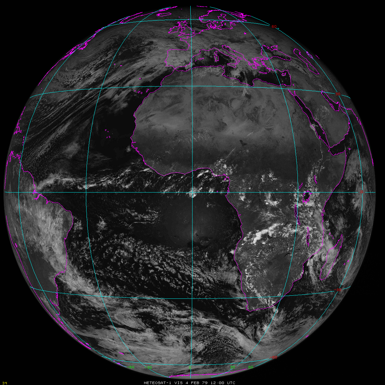
Archive of Meteosat-1 Data Discovered: European Organisation for the Exploitation of Meteorological Satellites (EUMETSAT) Director General Alain Ratier expressed his appreciation, saying it was fantastic that the Space Science and Engineering Center (SSEC) has retrieved Meteosat-1 data from December 1, 1978 through November 24, 1979; thereby some of the oldest data has been restored to their archive. The 226 Gigabytes of data were rescued from 9-track tapes about 15 years ago, and stored on disk in the raw, tape format. Recently, these data files were discovered and decoded, calibrated, and navigated by SSEC with a combination of 30-year old and newly-developed software. The value to climate studies at EUMETSAT was further noted by Joerg Schulz from the EUMETSAT Climate Services. (W.P. Menzel, CIMSS, 608-263-4930; D. Santek, CIMSS, 608-263-7410)
 (Click image to enlarge)
Figure caption: A Meteosat-1 visible image from 4 February 1979 at 1200 UTC.
VIIRS Winds Go Operational at ECMWF: The European Centre for Medium-range Weather Forecasts (ECMWF) began using the NESDIS Visible Infrared Imaging Radiometer Suite (VIIRS) polar winds in their operational numerical weather forecast model on 11 August 2016. First guess departure statistics of the VIIRS winds by ECMWF found that the Root Mean Square Vector Difference (RMSVD) is generally lower than the similar European Organisation for the Exploitation of Meteorological Satellites (EUMETSAT)-generated Metop Advanced Very High Resolution Radiometer (AVHRR) winds. Also, the VIIRS winds provide a small, positive impact in high-latitude forecasts. (D. Santek, CIMSS, 608-263-7410; J. Key, E/RA2, 608-263-2605, jkey@ssec.wisc.edu; S. Wanzong, CIMSS, 608-263-1950)
ITEMS FOR THE DIVISION CHIEF, CoRP:
GOES-R Legacy Atmospheric Profile Product Validation Tool Exercised: The Geostationary Operational Environmental Satellite (GOES)-R Data Operation Experiment (DOE-4) data have been exercised in the legacy atmospheric profile (LAP) product validation tool developed at the Cooperative Institute for Meteorological Satellite Studies (CIMSS). This web-based validation tool (http://soundingval.ssec.wisc.edu) has three main components: (1) imagery animations include a 24-hour loop for full disk, Contiguous U.S. (CONUS), meso-scale coverages. Animations can be viewed for variables such as Total Precipitable Water (TPW), stability parameters, temperature, and water vapor (100, 200, 300, 400, 500, 700, 850, and 1000 hPa); (2) Region-based plotting and visualization includes daily and weekly statistics for DOE4 data. The data are compared to RAOBs and other datasets; (3) Station-based plotting and visualization include daily and weekly comparisons with radiosonde and ground-based observations for each ground site. A deep dive capability is included in the time series of each variable including TPW, and the stability parameters over RAOB sites. The following link shows CONUS TPW animation in the validation tool from DOE-4 of 20 August 2016: http://soundingval.ssec.wisc.edu/imagery?action=view_data¶ms=source,region,output,parameter,level,date¶m_values=Test_DOE-4,GOES_16_CONUS,GOES-R_Algorithm,TPW,NA,20160820. (Tim Schmit, STAR, 608-263-0291, tim.j.schmit@noaa.gov; Jun Li, CIMSS, 608-262-3755, Jun.Li@ssec.wisc.edu)
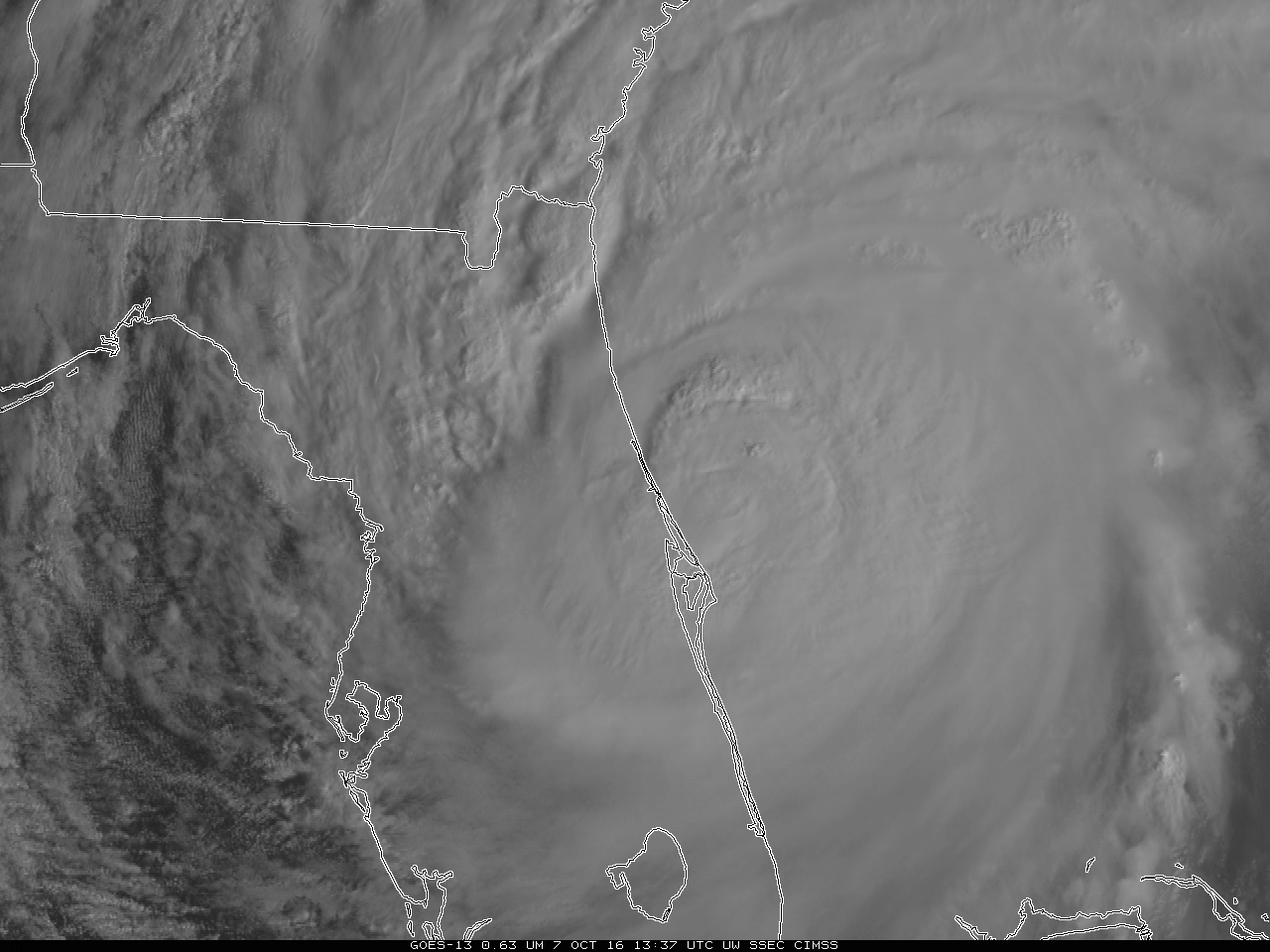
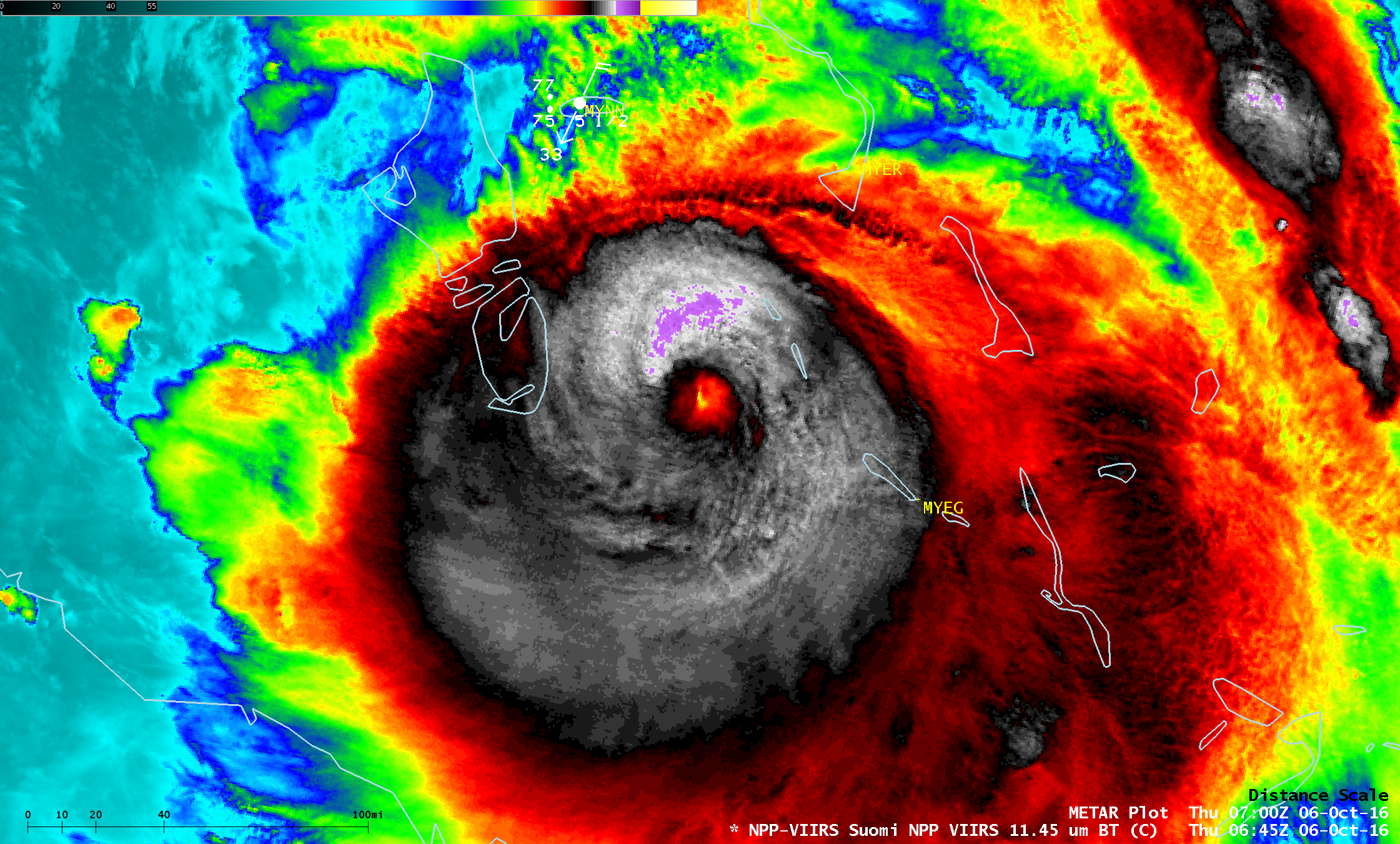
Hurricane Matthew Satellite Imagery: Several examples of images and animations of Hurricane Matthew were posted on the Cooperative Institute for Meteorological Satellite Studies (CIMSS) Satellite Blog (http://cimss.ssec.wisc.edu/goes/blog/?s=Matthew). Matthew reached Category 5 intensity as it moved through the Caribbean. (S. Lindstrom, CIMSS, 608-263-4425, S. Bachmeier, CIMSS, 608-263-3958)
 (Click image to enlarge)
Figure caption: Suomi NPP VIIRS Infrared image of Category 4 Hurricane Matthew over the Bahamas on October 6, 2016.
VISITORS:
NEXT WEEK:
LOOKING AHEAD:
| Archived Weeklies Page | Submit a report item |