[ Archive ]
| CIMSS-NOAA Weekly Report [ Archive ] |
ASPB AND CIMSS WEEKLY HIGHLIGHTS FOR THE WEEK ENDING OCTOBER 21, 2016
IN THE PRESS:
ITEMS FOR THE ADMINISTRATOR:
ITEMS FOR THE ASSISTANT ADMINISTRATOR:
ITEMS FOR THE OFFICE DIRECTOR, STAR:
Satellite Foundational Course for GOES-R Live in NWS LMS: The Satellite Foundational Course for GOES-R is now live in the Department of Commerce Learning Center. Cooperative Institute for Meteorological Satellite Studies (CIMSS) and Advanced Satellite Products Branch (ASPB) scientists contributed directly to 11 of the nearly 40 modules that comprise the training that is mandatory for all National Weather Service forecasters, including introductory material ("Basic Operations of GOES-R Satellites", "Multi-Channel Interpretation Approaches"), information on GOES-R Baseline Products ("Aerosols", "Clouds and Microphysics", "Legacy Atmospheric Profiles", "Derived Motion Winds", "Volcanic Ash", "Fire Characterization and Land Surface Characteristics"), and training on Synoptic Scale Features ("Fog/Low Clouds Formation and Dissipation", "TROWALS", "Cyclogenesis: Potential Vorticity Concepts") as viewed with satellite data. The scientists were also Subject Matter Experts (SME) on a number of other modules. (A. Heidinger, E/RA2, 608-263-6757, andrew.heidinger@noaa.gov; M. Pavolonis, E/RA2, 608-263-9597, mpav@ssec.wisc.edu; J. Key, E/RA2, 608-263-2605, jkey@ssec.wisc.edu; T. Schmit, E/RA2, 608-263-0291, tim.j.schmit@noaa.gov; J. Li, CIMSS, 608-262-3755; C. Velden, CIMSS, 608-262-9168; S. Bachmeier, CIMSS, 608-263-3958; C. Schmidt, CIMSS, 608-262-7973; S. Lindstrom, CIMSS, 608-263-4425; M. Gunshor, CIMSS, 608-263-1146; J. Gerth, CIMSS, 608-263-4942)
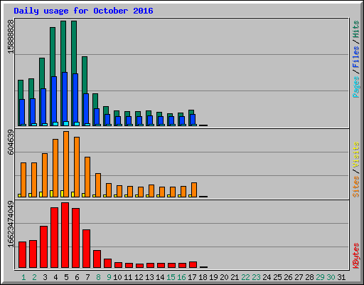
CIMSS Websites Extremely Popular During Hurricane Matthew: Websites at the Cooperative Institute for Meteorological Satellite Studies (CIMSS) were very popular during Hurricane Matthew. The CIMSS Tropical Cyclone webpage, which provides unique satellite-derived atmospheric analysis products in and around the hurricane to the NOAA/National Hurricane Center, NOAA/NESDIS/Satellite Analysis Branch, and many other interests around the world, had an average of almost 13.5TB of data transferred to 500,000 unique IP address each day between October 3-7, inclusive. On October 5 the Tropical Cyclone web server was averaging 185 requests/second and between 2000-2500 simultaneous connections throughout the day. The CIMSS Satellite Blog, which provides unique and educational analysis and discussion of satellite-based events around the globe, averaged over 21K unique site views and 600GB of data transferred during the same period of Hurricane Matthew. These two CIMSS sites continue to be some of the most critical sites for meteorologists to visit during high-impact tropical cyclone events, providing important data analysis and products for US operational forecast centers as well as thought-provoking interpretation of highlighted items of interest during these events. (T. Olander, CIMSS, 608-265-8005, C. Velden, CIMSS, 608-262-9168, S. Bachmeier, CIMSS, 608-263-3958, S. Lindstrom, CIMSS, 608-263-4425, John Lalande, SSEC, 608-263-2268)
 (Click image to enlarge)
Figure caption: Usage statistics for the CIMSS Tropical Cyclone website during October, 2016
VIIRS Polar Winds Validated Maturity Review: A JPSS Validated Maturity Review was held on 18 October 2015 for GCOM Day-1 products, MIRS products, Green Vegetation Fraction, VIIRS Polar Winds, the Vegetation Health Index Suite, and NUCAPS Outgoing Longwave Radiation (OLR) and the CrIS Ozone Profile. Jeff Key presented the VIIRS Polar Winds, with in-depth assessments of product performance relative to the system requirements in the Level-1 Requirements Document (L1RD) and the JPSS Requirements Document (JERD). The polar winds product was accepted as being at the "Validated" maturity stage. (J. Key, E/RA2, 608-263-2605, jkey@ssec.wisc.edu)
ITEMS FOR THE DIVISION CHIEF, CoRP:
Cloud Conference in Leipzig Germany: This week in Leipzig, Germany, the University of Leipzig held a workshop titled "Satellite Retrieval of Cloud Droplet Number Concentration". The workshop's goals were to document and understand capabilities and deficiencies of current approaches to retrieve this important cloud parameter from space. Andi Walther presented a talk on efforts to improve the cloud micro-physical retrievals in the operational NOAA Enterprise Cloud Algorithms. Andy Heidinger participated remotely. The workshop participants analyzed and discussed current retrievals and new ideas to improve passive remote sensing methods. The workshop agreed to draft a related publication, for which the Cooperative Institute for Meteorological Satellite Studies (CIMSS) cloud group will contribute. (A. Walther, CIMSS, andi.walther@ssec.wisc.edu, A. Heidinger, E/RA2, 608-263-6757, andrew.heidinger@noaa.gov)
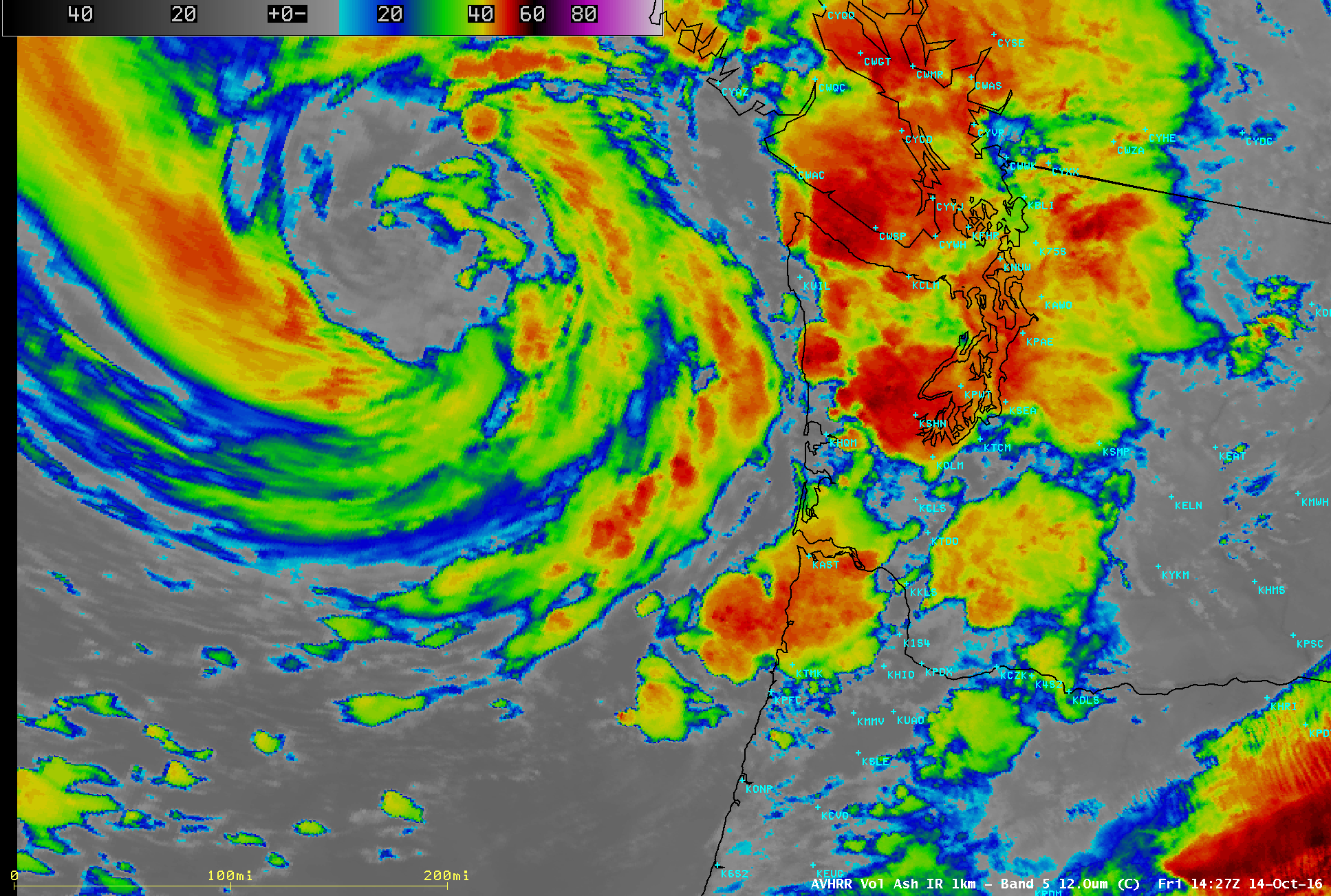
Satellite Imagery of Severe Weather Event in the Pacific Northwest: A variety of satellite images and products documenting a severe weather and heavy precipitation event in the Pacific Northwest were posted on the Cooperative Institute for Meteorological Satellite Studies (CIMSS) Satellite Blog (http://cimss.ssec.wisc.edu/goes/blog/archives/22329). During the 13-15 October 2016 period, two storms impacted the region (including one that was the remnants of West Pacific Super Typhoon Songda), bringing rounds of heavy precipitation and severe weather which included an EF-2 tornado in Manzanita, Oregon on 14 October. The event was also the topic of a Virtual Institute for Satellite Integration Training (VISIT) Satellite Chat (http://rammb.cira.colostate.edu/training/visit/satellite_chat/20161020) led by S. Lindstrom on October 20. (S. Lindstrom, CIMSS, 608-263-4425, S. Bachmeier, CIMSS, 608-263-3958)
 (Click image to enlarge)
Figure caption: POES AVHRR Infrared image of the storm system that produced an EF-2 tornado in Manzanita, Oregon on October 14, 2016.
VISITORS:
NEXT WEEK:
LOOKING AHEAD:
| Archived Weeklies Page | Submit a report item |