[ Archive ]
| CIMSS-NOAA Weekly Report [ Archive ] |
ASPB AND CIMSS WEEKLY HIGHLIGHTS FOR THE WEEK ENDING JANUARY 27, 2017
IN THE PRESS:
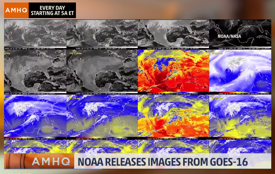
GOES-16 ‘First Light’ In the Media: Media outlets around the world picked up the GOES-16 First Light Advanced Baseline Imager (ABI) images produced by the Geostationary Operational Environmental Satellite (GOES)-R Algorithm Working Group (AWG) imagery team. The University of Wisconsin-Madison Cooperative Institute for Meteorological Satellite Studies (CIMSS) and the Colorado State University (CSU) Cooperative Institute for Research in the Atmosphere (CIRA) processed the images that were released by NOAA on January 23, 2016 (16 panel of all Advanced Baseline Imager (AB bands) and enhanced true color, respectively). These universally acclaimed images demonstrated ABI capabilities. Media coverage included: 1) A Weather Channel interview with T. Schmit that aired Wednesday morning on the AMHQ program (https://www.facebook.com/AMHQonTWC/videos/1535470476483444/); 2) the Milwaukee Journal Sentinel talked with M. Pavolonis and T. Schmit (http://www.jsonline.com/story/news/local/wisconsin/2017/01/25/uw-madison-team-key-developing-game-changing-weather-satellite/97002694/); 3) Channel 3 in Madison, WI did an on-camera piece with M. Pavolonis which aired at 10:00 pm January 24; 4) a University of Wisconsin-Madison news story (http://news.wisc.edu/goes-16-offers-earths-first-light-in-true-color/); and 5) an SSEC News article: (http://www.ssec.wisc.edu/news/articles/9626). Many more articles can be found at https://goo.gl/oZk5MY. (T. Schmit, E/RA2, 608-263-0291, tim.j.schmit@noaa.gov)
 (Click image to enlarge)
Figure caption: The graphic of the 16 ABI spectral bands during an interview with the Weather Channel.
Wall Street Journal Article on Volcanic Ash: Mike Pavolonis (NOAA/NESDIS/STAR) was interviewed for a Wall Street Journal article on the use of next generation satellite data to mitigate volcanic ash related aviation hazards in Indonesia. The article is available at http://www.wsj.com/articles/indonesia-fights-volcanic-risk-to-air-travel-1485086405?mg=id-wsj. (M. Pavolonis, E/RA2, 608-263-9597, Mike.Pavolonis@noaa.gov)
ITEMS FOR THE ADMINISTRATOR:
ITEMS FOR THE ASSISTANT ADMINISTRATOR:
ITEMS FOR THE OFFICE DIRECTOR, STAR:
CIMSS, ASPB, and SSEC Participation at the 2017 AMS Annual Meeting: Representatives from the Cooperative Institute for Meteorological Satellite Studies (CIMSS), Space Science and Engineering Center (SSEC), and the NOAA Advanced Satellite Products Branch (ASPB) participated in the 97th Annual American Meteorological Society (AMS) meeting held the week of January 22, 2017 in Seattle, WA. GOES-R/JPSS Short Courses were conducted on Saturday January 21st and Sunday January 22nd. There were over 80 oral presentations and posters by SSEC, CIMSS, and ASPB staff as part of the Student Conference, 13th Symposium on New Generation Operational Environmental Satellite Systems, 26th Symposium on Education, 29th Conference on Climate Variability and Change, 25th Symposium on Education, 14th Conference on Polar Meteorology and Oceanography, 18th Conference on Aviation, Range, and Aerospace Meteorology, Seventh Symposium on Advances in Modeling and Analysis Using Python, Eighth Conference on Environment and Health, 7th Conference on Transition of Research to Operation, Fifth Symposium on the Joint Center for Satellite Data Assimilation, and Third Symposium on High Performance Computing for Weather, Water, and Climate, 20th Conference Atmospheric Science Librarians International. Many participated in board, committee, and other side meetings on a host of topics. The SSEC booth in the exhibit hall highlighted advances with McIDAS-V, SSEC RealEarth, and other hardware/software support. Selected ‘one-page’ summaries of NOAA funded presentations will be posted at http://www.star.nesdis.noaa.gov/star/meetings.php. (W. Feltz, CIMSS/SSEC, 608-265-6283, wayne.feltz@ssec.wisc.edu; T. Schmit, E/RA2, 608-263-0291, tim.j.schmit@noaa.gov, J. Key E/RA2, A. Heidinger E/RA2)
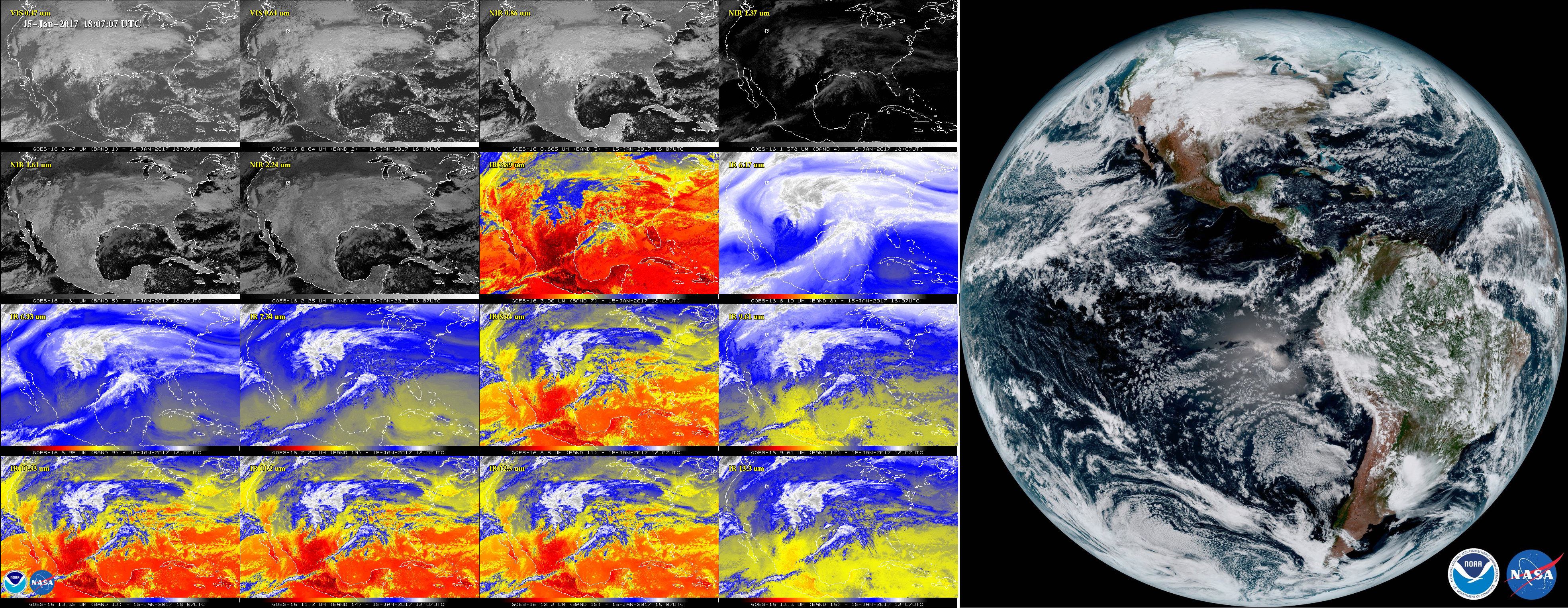
ABI First Light Imagery Provided: The GOES-R Algorithm Working Group (AWG) Imagery Team provided imagery for the NOAA GOES-16 Advanced Baseline Imager (ABI) First Light press release, posted on January 23, 2017. These images were generated using data from January 15th in a collaborative effort between the Cooperative Institute for Meteorological Satellite Studies (CIMSS), the Cooperative Institute for Research in the Atmosphere (CIRA), and NOAA/NESDIS/STAR scientists collocated at the cooperative institutes. The first light images appeared in reports from multiple news organizations online and on television, were featured by NASA, NOAA, and industry partners in the exhibit hall at the American Meteorological Society (AMS) Annual Meeting in Seattle, and they appeared in over half a dozen presentations in various sessions at the AMS Annual Meeting. (M. Gunshor, CIMSS, 608-263-1146, T. Schmit, E/RA2, 608-263-0291, tim.j.schmit@noaa.gov)
 (Click image to enlarge)
Figure caption: The GOES-R Advanced Baseline Imager (ABI) First Light Images from the NOAA Press release with all 16 bands of the ABI shown in the 16 panel on the left (credit CIMSS) and the “Enhanced True Color” full disk image on the right (credit CIRA).
ITEMS FOR THE DIVISION CHIEF, CoRP:
GOES-R presentations part of AMS and ESIP Education Sessions: In an on-going effort to raise awareness around new capabilities associated with the Geostationary Operational Environmental Satellite (GOES)-16, three presentations were conducted during the American Meteorological Society (AMS) Education Symposium in Seattle January 23rd and 24th and another at the Earth Science Information Partners (ESIP) meeting in Washington DC on January 12th. Reaching well over 100 educators, these talks were part of the GOES-R Education Proving Ground project (http://cimss.ssec.wisc.edu/education/goesr/) out of NOAA's Cooperative Institute for Meteorological Satellite Studies. (M. Mooney, CIMSS, 608-265-2123, S. Lindstrom, CIMSS, 608-263-4425, M. Gunshor, CIMSS, 608-263-1146, T. Schmit, E/RA2, 608-263-0291)
 (Click image to enlarge)
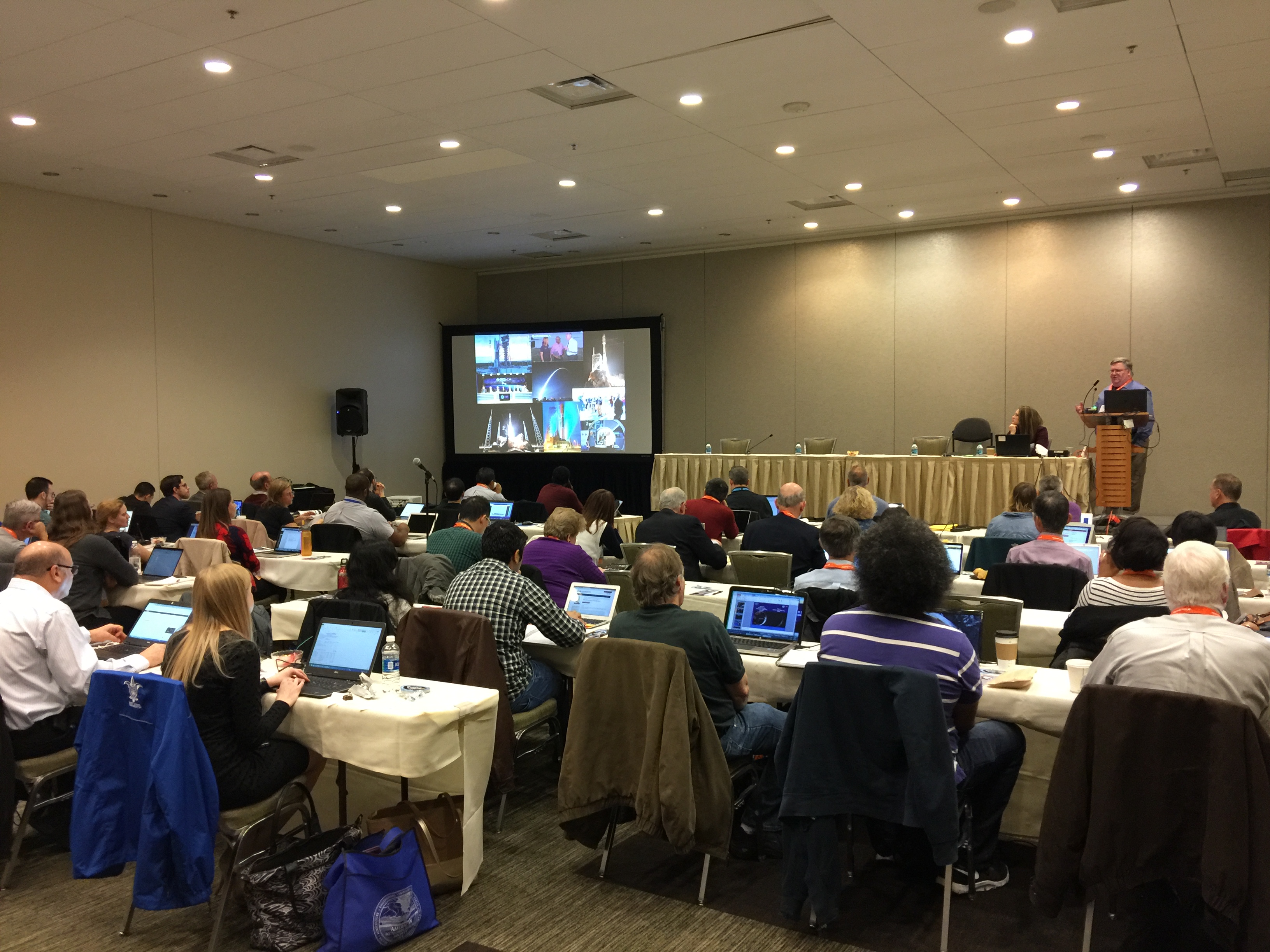
CIMSS and ASPB Support GOES-R AMS Short Course: Scientists from the Cooperative Institute for Meteorological Satellite Studies (CIMSS) and the NOAA Advanced Satellite Products Branch (ASPB) helped organize and successfully led a short course at the American Meteorological Society (AMS) Annual Meeting, focused on Geostationary Operational Environmental Satellite (GOES)-R. The short course, titled "GOES-R Preview for all GOES Users" had high attendance with a diverse mix of about 40 domestic and international participants from government, academia, and private industry, ranging from operational forecasters to university researchers. The course goal was to make current and future GOES users aware of the new GOES-R series capabilities and how they will improve environmental observations and forecasts. There was a mix of presentations (at http://cimss.ssec.wisc.edu/goes/shortcourse/seattle2017.html) and hands-on exercises on the Advanced Baseline Imager (ABI), Geostationary Lightning Mapper (GLM), space weather instruments, and GOES-R derived products and the initial feedback was overwhelmingly positive. (M. Gunshor, CIMSS, 608-263-1146, T. Schmit, E/RA2, 608-263-0291, tim.j.schmit@noaa.gov, J. Gerth, CIMSS, C. Schmidt, CIMSS, S. Lindstrom, CIMSS)
 (Click image to enlarge)
Figure caption: Mike Stringer, GOES-R System Program Director, presenting a GOES-R overview at the AMS Annual Meeting Short Course: GOES-R Preview for all GOES Users.
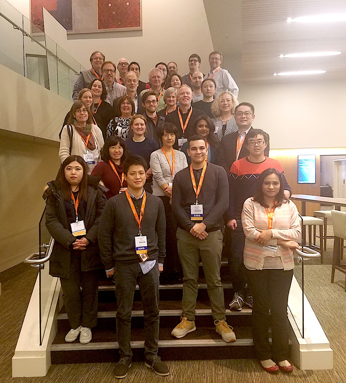
CIMSS and ASPB Support JPSS AMS Short Course: The Cooperative Institute for Meteorological Satellite Studies (CIMSS) and the NOAA Advanced Satellite Products Branch (ASPB) helped organize and lead the JPSS Short Course held on January 21, 2016, in conjunction with the American Meteorological Society (AMS) Annual Meeting in Seattle, WA. The JPSS course focused on applications of the new generation JPSS satellite system to a variety of operational forecasting scenarios. It included both informative lectures and hands-on activities in data access, fires, sea ice, and severe weather. The RealEarth application and other training resources were demonstrated. CIMSS/ASPB instructors included Kathy Strabala, Dave Santek, Nick Bearson, and Jeff Key. Jordan Gerth was the short course co-chair. There were 16 students. (J. Key, E/RA2, 608-263-2605, jkey@ssec.wisc.edu)
 (Click image to enlarge)
Figure caption: JPSS Short Course group photo.
Paper Submitted on Validation of the ATMS/CrIS NUCAPS Temperature Product using COSMIC GPS RO: A paper was recently submitted to the Journal of Geophysical Research - Atmospheres entitled "Assessment of NOAA NUCAPS Upper Air Temperature Profiles Using COSMIC GPS Radio Occultation and ARM Radiosondes" (M.L. Feltz, L. Borg, R.O. Knuteson, D. Tobin, H. Revercomb, and A. Gambacorta ). Comparisons of the NOAA Unique Combined Atmospheric Processing System (NUCAPS) vertical temperature profile product are made to radiosonde, radio occultation (RO), and to other hyperspectral infrared sounder temperature products in attempts to assess the accuracy of the NUCAPS product within the stratosphere. When temperature averaging kernels (AKs) were applied, NUCAPS bias relative to radiosondes from 40-100 hPa was found to be under 0.5 K (with root mean square error under 1 K). When using RO as a common reference and AKs were applied, NUCAPS agreement with Infrared Atmospheric Sounding Interferometer (IASI) and Atmospheric Infrared Sounder (AIRS) operational temperature retrievals was found to be under 0.5 K. (L. Borg, SSEC, 608-265-9911)
VISITORS:
NEXT WEEK:
LOOKING AHEAD:
| Archived Weeklies Page | Submit a report item |