[ Archive ]
| CIMSS-NOAA Weekly Report [ Archive ] |
ASPB AND CIMSS WEEKLY HIGHLIGHTS FOR THE WEEK ENDING FEBRUARY 3, 2017
IN THE PRESS:
Engagement with Reinsurance Stakeholders: There has been continued engagement with NOAA's Insurance and Reinsurance stakeholders regarding the recently published findings on U.S. coastal hurricane risk. A recent story appears here: http://media.bmsgroup.com/?p=5628. (J. Kossin, NCEI/CWC, 608-265-5356)
Through the Atmosphere, Winter/Spring 2017: Through the Atmosphere is a semiannual magazine published by the University of Wisconsin-Madison Space Science and Engineering Center (SSEC) and the Cooperative Institute for Meteorological Satellite Studies (CIMSS). Highlights of the 2017 Winter/Spring issue include: 1) the results of new hurricane research, 2) SSEC scientists' calibration and validation efforts in preparation for JPSS-1, 3) STEM teachers and GOES-16 training at CIMSS, 4) Hank Revercomb, 2017 Fellow of the American Meteorological Society, and 5) a retrospective on the 50th anniversary of ATS-I. The entire issue is available here: http://www.ssec.wisc.edu/news/articles/9713. (J. Phillips, SSEC, 608-262-8164, L. Avila, CIMSS, Eric Verbeten, SSEC) 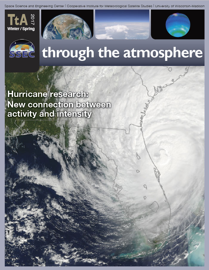 (Click image to enlarge)
ITEMS FOR THE ADMINISTRATOR:
ITEMS FOR THE ASSISTANT ADMINISTRATOR:
ITEMS FOR THE OFFICE DIRECTOR, STAR:
NOAA/CIMSS Products Alert Forecasters to Developing Fog Hazard: On several occasions during the week of January 29, 2017, the National Weather Service (NWS) in Hanford, CA utilized quantitative fog and low stratus products developed by NOAA/NESDIS/STAR, in collaboration with the Cooperative Institute for Meteorological Satellite Studies (CIMSS), to identify regions of developing fog in California’s Great Central Valley. The Great Central Valley fog, known as Tule fog, can reduce surface visibility to less than 1/4 of a mile. As such, the Tule fog is a major hazard that severely disrupts travel, even resulting in school delays. The NOAA/CIMSS fog products were also used by the NWS to directly communicate the hazard to the general public via social media (https://twitter.com/NWSHanford/status/826436211178876928). The NWS routinely utilizes the NOAA/CIMSS fog products via an experimental data feed from the University of Wisconsin. NESDIS operations is tentatively expected to begin production of the NOAA/CIMSS fog products by August of 2017. For additional information on the recent Tule fog events, refer to the CIMSS Satellite Blog (http://cimss.ssec.wisc.edu/goes/blog/archives/23023). (M. Pavolonis, E/RA2, 608-263-9597, Mike.Pavolonis@noaa.gov, S. Bachmeier, CIMSS, C. Calvert, CIMSS, S. Lindstrom, CIMSS) 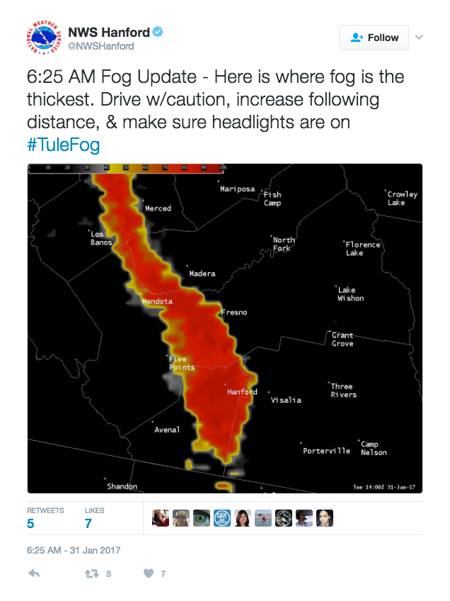 (Click image to enlarge)
Figure caption: Fog and low stratus products developed by NOAA/NESDIS/STAR, in collaboration with the Cooperative Institute for Meteorological Satellite Studies (CIMSS), are used by the National Weather Service (NWS) to directly communicate low visibility hazards to the general public via social media. The orange and red colors in the image indicate a high probability of low visibility conditions as determined by the NOAA/CIMSS algorithm.
ITEMS FOR THE DIVISION CHIEF, CoRP:
UW-Madison AOS Department Seminar on Real-time Air Quality Modeling System: Brad Pierce gave a presentation entitled “Real-time Air Quality Modeling System (RAQMS) Chemical and Aerosol Data Assimilation and Global Air Quality Forecasting” at the University of Wisconsin-Madison Atmospheric and Oceanic Sciences (AOS) Department Seminar on February 1, 2017, in Madison, WI. The talk presented results from RAQMS ozone and aerosol data assimilation experiments assessing the impacts of intercontinental pollution transport, stratospheric intrusions, and wildfires on global air quality. The RAQMS assimilation and forecasting experiments help to guide the development of future operational ozone and aerosol forecasting systems within the NOAA Environmental Modeling System (NEMS) Global Forecasting System (GFS) Aerosol Component (NGAC) and the Next Generation Global Prediction System (NGGPS) under development at the National Centers for Environmental Prediction (NCEP) (R.B. Pierce, E/RA2, 608-890-1892, brad.pierce@noaa.gov)
 (Click image to enlarge)
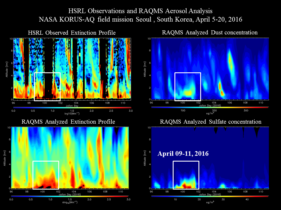
Figure caption: Profiles of University of Wisconsin-Madison Space Science and Engineering Center (SSEC) High Spectral Resolution Lidar (HSRL) observed (upper left, Mm-1) and Real-time Air Quality Modeling System (RAQMS) analyzed (lower left, Mm-1) aerosol extinction along with RAQMS analyzed dust (upper right, ug/m3) and sulfate (lower right, ug/m3) aerosol concentrations at Seoul South Korea on April 5-20, 2016 during the NASA KORUS-AQ field mission.
Manuscript on deep convective cloud monitoring with advanced infrared imager and sounder accepted for publishing: A manuscript titled "Deep Convective Cloud Characterizations from both Broadband Imager and Hyperspectral Infrared Sounder Measurements" has been accepted for publishing in Journal of Geophysical Research - Atmospheres (http://onlinelibrary.wiley.com/doi/10.1002/2016JD025408/abstract). This paper demonstrated that measurements from hyperspectral IR sounders are much more sensitive to high cloud tops than broadband imager measurements, indicating that a hyperspectral IR sounder can identify deep convective clouds (DCCs) with better accuracy. Co-authors are Yufei Ai (Peking University, Wenjing Shi (Institute of Atmospheric Physics, Chinese Academy of Sciences), Jun Li (CIMSS), Timothy J. Schmit (STAR), Changyong Cao (STAR), and Wanbiao Li (Peking University). (Jun Li, CIMSS, Jun.Li@ssec.wisc.edu, 608-262-3755)
VISITORS:
NEXT WEEK:
LOOKING AHEAD:
| Archived Weeklies Page | Submit a report item |