[ Archive ]
| CIMSS-NOAA Weekly Report [ Archive ] |
ASPB AND CIMSS WEEKLY HIGHLIGHTS FOR THE WEEK ENDING MARCH 3, 2017
IN THE PRESS:
GLAWEX 2017 Media Coverage: The last day of the Great LAkes Winter Experiment, held in/on Green Bay, Wisconsin February 24-27, 2017, involved the U.S. Coast Guard icebreaker Mobile Bay. Local media coverage of the work on the icebreaker included articles and videos from CBS (Local 5; http://www.wearegreenbay.com/news/local-news/scientists-look-at-ice-conditions-on-the-bay-of-green-bay/664265796), NBC (NBC26; http://www.nbc26.com/news/us-coast-guards-ship-pushes-through-a-frozen-lake-michigan), and ABC (WBAY; http://wbay.com/2017/02/27/noaa-scientists-to-document-ice-during-coast-guard-operations/). (J. Key, E/RA2, 608-263-2605, jkey@ssec.wisc.edu)
ITEMS FOR THE ADMINISTRATOR:
ITEMS FOR THE ASSISTANT ADMINISTRATOR:
ITEMS FOR THE OFFICE DIRECTOR, STAR:
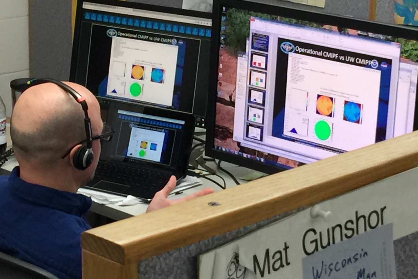
CIMSS Support for the GOES-16 Imagery PS-PVR: On February 28th, T. Schmit and M. Gunshor presented at the Geostationary Operational Environmental Satellite (GOES)-16 Imagery Beta Peer Stakeholder - Product Validation Review (PS-PVR). The purpose of this review was to determine if imagery was mature enough to be at the beta stage, meaning Advanced Baseline Imager (ABI) data could subsequently be sent over the GOES-R ReBroadcast (GRB). The review team stated that the imagery is ready for the beta stage. (T. Schmit, E/RA2, 608-263-0291, tim.j.schmit@noaa.gov; M. Gunshor, CIMSS, 608-263-1146)
 (Click image to enlarge)
Figure caption: Mat Gunshor, CIMSS, presenting at the GOES-R Imagery review.
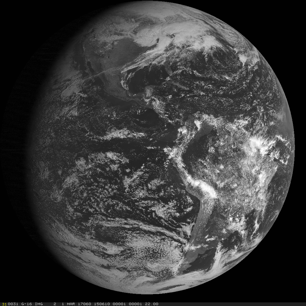
GOES-16 data being ingested at UW SSEC/CIMSS: The University of Wisconsin Space Science and Engineering Center (SSEC) Satellite Data Services' data center is successfully ingesting GOES-16 data. All Advanced Baseline Imager (ABI) data sent over the GOES-ReBroadcast (GRB), including all instruments currently present but not including fill data, have been ingested, and all data are stored on the University of Wisconsin SSEC Satellite Data Services' system.
 (Click image to enlarge)
Figure caption: GOES-16 Channel 02 from March 1, 2017 at 15:06 UTC as received by the University of Wisconsin SSEC/CIMSS.
Two New Papers on Utilizing Satellites to Analyze Tropical Cyclones: Two studies have been published and are to appear in the March issue of Monthly Weather Review that employ satellite observations to observe tropical cyclones. The first is "Reprocessing the Most Intense Historical Tropical Cyclones in the Satellite Era Using the Advanced Dvorak Technique", by C. Velden, T. Olander, D. Herndon and J. Kossin. In this study, the most updated version of an objective satellite-based intensity estimation algorithm [Advanced Dvorak Technique (ADT)] is employed and applied to the highest-resolution (spatial and temporal) geostationary satellite data available for extreme-intensity tropical cyclones that occurred over the globe during the era of these satellites (1979–present). The second paper is "Assimilation of High-Resolution Satellite-Derived Atmospheric Motion Vectors: Impact on HWRF Forecasts of Tropical Cyclone Track and Intensity", by C. Velden, W. Lewis, W. Bresky, D. Stettner, J. Daniels and S. Wanzong. In this study, the impact of direct assimilation of enhanced (higher resolution) satellite-derived atmospheric motion vectors (AMVs) into the NCEP operational Hurricane Weather Research and Forecasting Model (HWRF) system is investigated. Forecasts of Atlantic tropical cyclone track and intensity show a modest positive impact by inclusion of the enhanced AMVs via direct assimilation. (C. Velden, CIMSS, 608-262-9168, T. Olander, CIMSS, 608-265-8005, D. Herndon, CIMSS, 608-262-6741, J. Kossin, NCEI/CWC, 608-265-5356, W. Lewis, CIMSS, 608-262-8954, J. Daniels, STAR, D. Stettner, CIMSS, 608-262-8850, S. Wanzong, CIMSS, 608-263-1950).
NASA Health and Air Quality Applied Science Team Meeting: Brad Pierce presented a talk entitled “Off-line constraints on NEI2011 NOx emissions using CMAQ/GSI/OMI tropospheric NO2 Data Assimilation” at the Second NASA Health and Air Quality Applied Science Team (HAQAST) meeting hosted by the University of Washington on February 27 – March 02, 2017 in Seattle, Washington. HAQAST2 is intended to build dialogue between members the HAQAST research team and organizations related to health and air quality, including local/state/federal agencies, businesses, non-profits, educators, and other organizations. The discussions focused on the role of NASA data in health and air quality applications and included presentation of new research results, perspectives of professionals in the health and air quality communities, examples of earth science data for decision-making applications, and discussion of the barriers and opportunities in linking NASA Earth Science with health and air quality users and needs (R.B. Pierce, E/RA2, 608-890-1892, brad.pierce@noaa.gov)
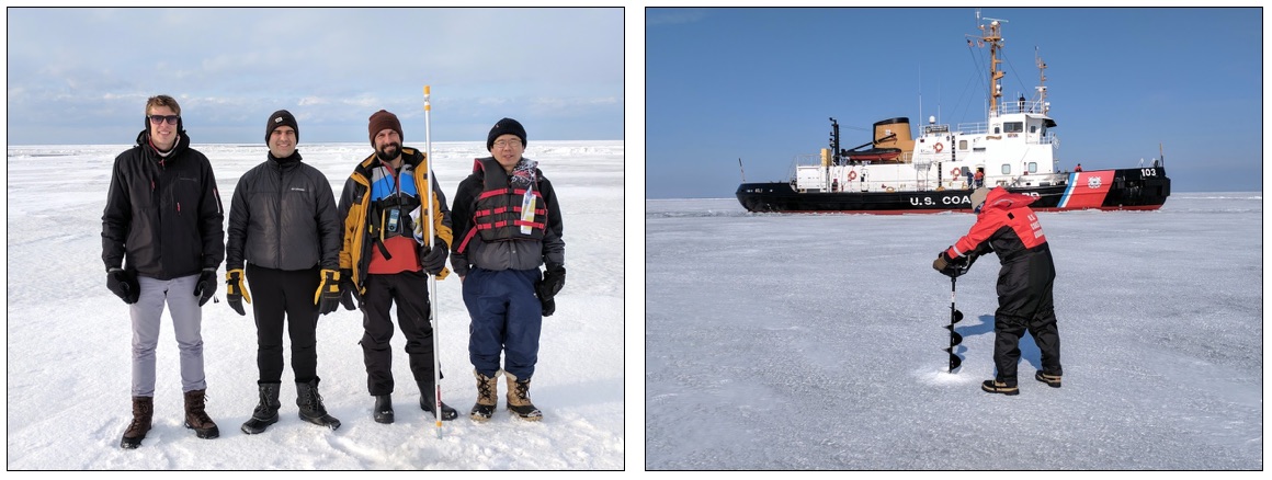
Great LAkes Winter Experiment (GLAWEX), 2017: The Great LAkes Winter Experiment (GLAWEX) took place in Green Bay, Wisconsin and the Upper Peninsula of Michigan, 24-27 February 2017. Scientists from a number of government agencies and universities collected measurements of ice in Green Bay and of snow and lake ice properties in Michigan’s Upper Peninsula, including NOAA/STAR,the Cooperative Institute for Meteorological Satellites Studies (CIMSS), the National Ice Center (NIC), and the Great Lakes Environmental Research Lab (GLERL, Ann Arbor). GLAWEX was supposed to have overflights of the Naval Research Lab (NRL) P3 aircraft, but mechanical problems prevented it from making the flight from Colorado, where it was participating in NASA's SnowEx campaign, to the Great Lakes region. The U.S. Coast Guard icebreaker Mobile Bay took some GLAWEX scientists further into the bay to make ice measurements and to deploy two drifting buoys provided by the University of Washington. Yinghui Liu and Aaron Letterly from CIMSS, and Jeff Key (STAR), participated. The purpose of the CIMSS/NOAA portion of the GLAWEX campaign was to collect ground based and airborne measurements in support of GOES-16 ABI baseline and future product validation during the GOES-16 Post Launch Test (PLT). JPSS (S-NPP) product validation will also be performed. (J. Key, E/RA2, 608-263-2605, jkey@ssec.wisc.edu)
 (Click image to enlarge)
Figure caption: Left: Aaron Letterly (CIMSS), Matt Welshans (NIC), Sean Helfrich (NIC), and Yinghui Liu (CIMSS) on the ice of Green Bay. Right: George Leshkevich (GLERL) drilling a hole near the USCG Mobile Bay ice breaker.
ITEMS FOR THE DIVISION CHIEF, CoRP:
Consulting Expert for PBS Nova Television Series: Jim Kossin (NCEI/CWC) has agreed to serve as an independent content-expert for the Public Broadcasting System (PBS) Nova television series "Volatile Earth", which is currently in production. (J. Kossin, NCEI/CWC, 608-265-5356)
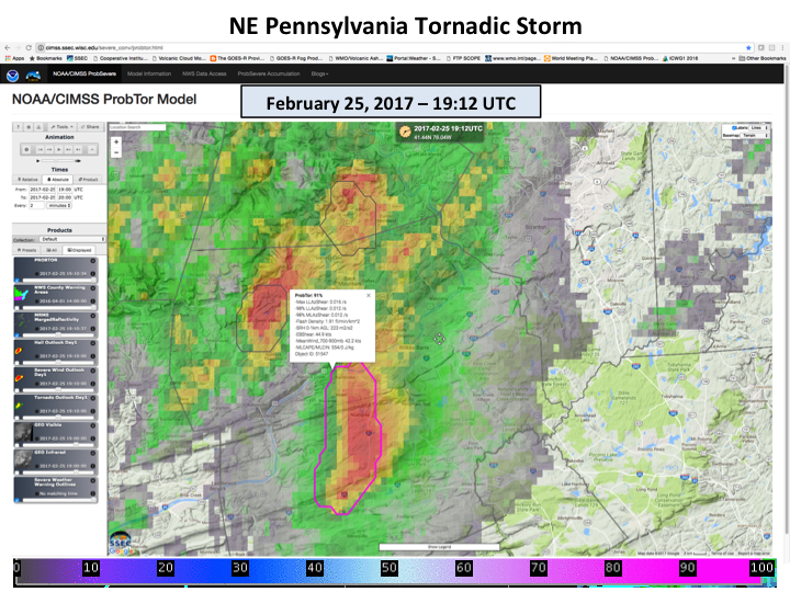
New Model for Improving Tornado Warnings: NOAA/NESDIS/STAR, in collaboration with the Cooperative Institute for Meteorological Satellite Studies (CIMSS), have developed the Probability of Tornado (ProbTor) short term forecast model. ProbTor, which is an extension of the Probability of Severe (ProbSevere) model, is aimed at improving the lead time and accuracy of operational tornado warnings through the provision of probabilistic storm centric guidance. ProbTor combines Numerical Weather Prediction (NWP), radar, and lightning data to determine the probability that a given existing storm cell will produce a tornado up to 30 minutes in the future. In extensive testing, ProbTor was shown to improve the lead time of tornado warnings by 5 to 10 minutes. National Weather Service forecasters at the 2017 Hazardous Weather Testbed will evaluate ProbTor. It is anticipated that cloud property and lightning measurements from GOES-16 will add significant value to ProbTor in the future. (M. Pavolonis, E/RA2, 608-263-9597, Mike.Pavolonis@noaa.gov, J. Cintineo, CIMSS, J. Sieglaff, CIMSS, J. Brunner, CIMSS)
 (Click image to enlarge)
Figure caption: A storm cell in Northeastern Pennsylvania on February 25 at 19:12 UTC (2:12PM EST) is given a 91% chance of producing a tornado by the ProbTor model (radar depicted storm cell with text readout). The storm did produce a damaging tornado, with 120 mph winds, from 19:35 UTC (2:35PM EST) to 19:50 UTC (2:50PM EST). ProbTor strongly implied that tornado generation was very likely 23 minutes before the tornado formed and 10 minutes before the National Weather Service issued a tornado warning.
Class on Weather Satellite Applications: A. Heidinger finished lecturing in the University of Wisconsin-Madison Atmospheric and Oceanic Sciences (AOS) Department's course on Weather Satellite Applications (AOS-745). This class is co-taught with Dr Paul Menzel and Professor Steve Ackerman. A. Heidinger lectured in January and February and topics including radiative transfer modeling, remote sensing with solar reflectances and solar energy applications . This class is being developed in collaboration with Hampton University - a member of the Cooperative Remote Sensing Science and Technology Center (CREST) Consortium. Teaching at the university level provides NOAA scientists opportunities to interact with the next generation of scientists and to keep their skill sets current and relevant. (A. Heidinger, E/RA2, 608-263-6757, andrew.heidinger@noaa.gov)
VISITORS:
NEXT WEEK:
LOOKING AHEAD:
| Archived Weeklies Page | Submit a report item |