[ Archive ]
| CIMSS-NOAA Weekly Report [ Archive ] |
ASPB AND CIMSS WEEKLY HIGHLIGHTS FOR THE WEEK ENDING MAY 19, 2017
IN THE PRESS:
AOSS Photo Contest Entries Featured on weather.com: The entries from this year's Atmospheric, Ocean, and Space Sciences (AOSS) photo contest were featured on weather.com (The Weather Channel), May 18, 2017. See the entries at https://weather.com/news/news/2017-atmospheric-oceanic-space-science-photo-contest-university-wisconsin-madison-ssec. (J. Phillips, SSEC)
ITEMS FOR THE ADMINISTRATOR:
ITEMS FOR THE ASSISTANT ADMINISTRATOR:
ITEMS FOR THE OFFICE DIRECTOR, STAR:
Bob Aune Retires: Bob Aune, Advanced Satellite Products Branch (ASPB), retired from NOAA on April 30, 2017. He worked in meteorology for more than 40 years. After earning his B.S. (1975) and M.S. (1983) degrees from Penn State University, he was commissioned in the U.S. Navy in 1976. He spent four years at Fleet Weather Central in Pearl Harbor, then completed an additional 16 years as a Reserve Officer for the Navy Oceanography Reserve Command in Monterey, Norfolk, Washington (D.C.), Illinois, and Spain. He retired from the Navy in 1993. Before coming to NOAA in Madison in 1987, Bob worked for STX Hughes Corporation for five years on a contract under Dr. Louis Uccellini. His research emphasis has been on the use of satellite observations in numerical prediction models. His most recent work has been on the use of GOES sounders for near-casting. (J. Key, E/RA2, 608-263-2605, jkey@ssec.wisc.edu)
Best Publication Award: The NOAA Atlantic Oceanographic and Meteorological Laboratory (AOML) has named a paper by Jason Dunion, Chris Thorncroft and Chris Velden for the '2016 Best Paper Award'. The publication is "The Tropical Cyclone Diurnal Cycle of Mature Hurricanes", published in Monthly Weather Review in October of 2014. The award considers all relevant publications with an AOML (or affiliated) author over the previous few years. AOML also nominated it for the NOAA Office of Oceanic and Atmospheric Research (OAR) best paper award. (C. Velden, CIMSS, 608-262-9168; J. Dunion, CIMAS)
Manuscript on Improving AIRS Sounding Retrieval Published: The manuscript entitled "Improved AIRS temperature and moisture soundings with local a priori information for the 1DVAR", has been published in the Journal of Atmospheric and Oceanic Technology. Co-authors are Hyun-Sung Jang, B. J. Sohn, Hyoung-Wook Chun (Seoul National University), Jun Li, and Elisabeth Weisz (CIMSS). (Jun Li, CIMSS, 608-262-3755, Jun.Li@ssec.wisc.edu)
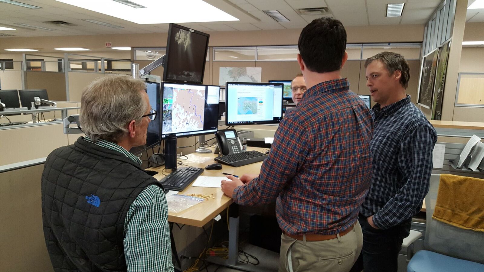
Direct Broadcast Support of Operational Forecasters in Alaska: Cooperative Institute for Meteorological Satellite Studies (CIMSS) personnel made a visit to the Alaska National Weather Service (NWS) forecast offices in Anchorage, Fairbanks and Juneau, May 8-12, to learn how the operational forecasters are using polar orbiter direct broadcast products, and to introduce new products that will soon be available for real-time use. The offices use processing software provided by CIMSS to create and reformat products for display in the Advanced Weather Interactive Processing System (AWIPS). The software packages are the NOAA Community Satellite Processing Package (CSPP), and the NASA International MODIS/AIRS Processing Package (IMAPP). Forecasters provided good feedback on the utility of the direct broadcast products, including recommendations on improvements to delivery and display of the data. (K. Strabala, CIMSS, 608-263-8752, J. Gerth, CIMSS, 608-263-4942, D. Hoese, CIMSS)
 (Click image to enlarge)
Figure caption: Jordan Gerth and Carl Dierking discuss the VIIRS Flood Product with Anchorage, Alaska operational forecasters. The product will soon be part of the CSPP software suite supporting Suomi-National Polar-orbiting Partnership (S-NPP) direct broadcast.
Several GOES-16 Level 2 Products Pass to Beta Stage: An Advanced Baseline Imager (ABI) Level 2 products Beta Peer Stakeholder - Product Validation Review (PS PVR) was held on May 16, 2017. Several products successfully passed to the beta stage, this included: cloud phase, cloud top properties and soundings. Having achieved Beta, these products will now be made experimentally available to users. These products will face a Provisional Review sometime in November, 2017. (A. Heidinger, E/RA2, 608-263-6757, andrew.heidinger@noaa.gov; M. Pavolonis, E/RA2, 608-263-9597, mpav@ssec.wisc.edu; T. Schmit, E/RA2, 608-263-0291, tim.j.schmit@noaa.gov)
ITEMS FOR THE DIVISION CHIEF, CoRP:
WMO Executive Council Side Event on Polar Activities: During the 69th Session of the World Meteorological Organization (WMO) Executive Council, Jeff Key participated in a side event on WMO's polar and high mountain activities. He presented the observational framework of the Global Cryosphere Watch program (GCW, globalcryospherewatch.org) and the Polar Space Task Group (PSTG). (Key is the GCW Science Advisor, a GCW working group co-lead, and the PSTG Vice-Chair.) The side event preceded the Executive Council discussion on Polar and High Mountain activities. On a related note, WMO was just granted observer status in the Arctic Council. The 10th Arctic Council ministerial meeting in Fairbanks, Alaska in May 2017 - where the U.S. ended its two-year chairmanship of the Arctic Council - recognized the “need to increase cooperation in meteorological, oceanographic and terrestrial observations, research and services, and the need for well-maintained and sustained observation networks and continuous monitoring of the Arctic, such as the World Meteorological Organization’s Global Cryosphere Watch Program.” (J. Key, E/RA2, 608-263-2605, jkey@ssec.wisc.edu)
 (Click image to enlarge)
TROPICS User-Applications Workshop: Last spring, NASA selected the Time-Resolved Observations of Precipitation structure and storm Intensity with a Constellation of Smallsats (TROPICS) Mission as part of a venture-class proposal solicitation. TROPICS is a mission that will be launched in the 2020 timeframe and will be comprised of a constellation of microsatellites with passive microwave sounders similar to the NOAA/NASA Suomi-NPP and Joint Polar Satellite System (JPSS) Advanced Technology Microwave Sounder (ATMS) and will provide temperature, humidity, and precipitation measurements with temporal frequency of around 30 minutes in the tropics. This mission will help our understanding of tropical cyclone development through tracking of temperature, humidity, and precipitation changes, as well as inform collaborating agencies on the potential utility of smallsat constellations. As a first step in examining the potential of the mission for applied science, NASA’s Earth Science Division Applied Sciences Program sponsored the 1st TROPICS Applications Workshop at the University of Miami on May 8-10, 2017. The objectives of this meeting were to 1) introduce a broad community of potential end-users (e.g., university, operational forecasting, broader applications/decision making community) to the expected value of TROPICS by reviewing mission specifications and status, 2) provide a forum for applied researchers and operational decision makers to share insight into how observations from TROPICS can be used in their organizations, and 3) begin establishment an early adopter community that will be used to highlight potential TROPICS applications and accelerate post-launch application for users. The workshop hosted about 50 attendees, and successfully met its goals. (C. Velden, CIMSS, 608-262-9168)
NWS Virtual Lab Forum on ProbSevere: M. Pavolonis (NOAA/NESDIS/STAR) gave a National Weather Service (NWS) Virtual Lab (VLab) forum briefing on the ProbSevere (“Probability of Severe”) model developed by STAR, in collaboration with the Cooperative Institute for Meteorological Satellite Studies (CIMSS). The NWS VLab is a service and framework, which enables NOAA employees, and their partners to share ideas, collaborate, engage in software development, and conduct applied research. The ProbSevere briefing included an overview of ProbSevere, an update on the effort to transition ProbSevere to NWS operations, and a summary of recent research to improve ProbSevere, including the determination of hazard specific severe weather probabilities (wind, hail, and tornado). The VLab forum, which included 30 minutes of questions and discussion, is an effective way to interact and communicate with NWS users on a broad scale. The briefing was recorded and is available at https://vlab.ncep.noaa.gov/web/guest/vlab-forum. (M. Pavolonis, E/RA2, 608-263-9597, Mike.Pavolonis@noaa.gov)
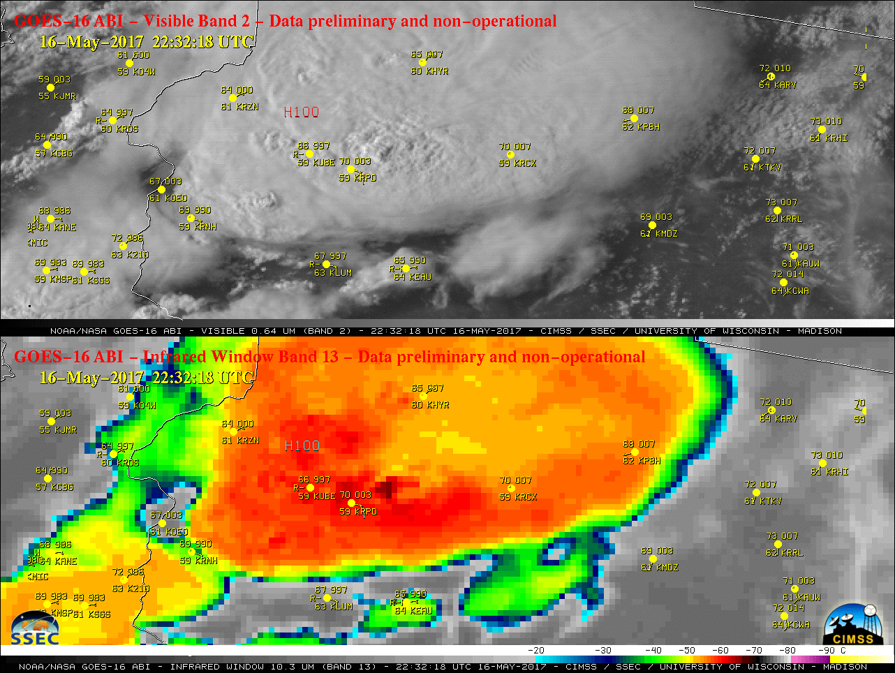
GOES-16 Images of Large Hail and Fatal Tornado Event in Wisconsin: Geostationary Operational Environmental Satellite (GOES)-16 visible and infrared images of a large hail and tornado event in northwestern Wisconsin on May 16, 2017 were posted on the Cooperative Institute for Meteorological Satellite Studies (CIMSS) Satellite Blog (http://cimss.ssec.wisc.edu/goes/blog/archives/23962). A strong supercell thunderstorm produced hail as large as 3.0 inches in diameter, as well as a long-track tornado that was responsible for 1 fatality and 25 injuries. (S. Bachmeier, CIMSS, 608-263-3958, K. Bah, CIMSS)
 (Click image to enlarge)
Figure caption: GOES-16 Visible (0.64 µm, top) and Infrared Window (10.3 µm, bottom) images near the time of the fatal tornado event in Chetek, Wisconsin.
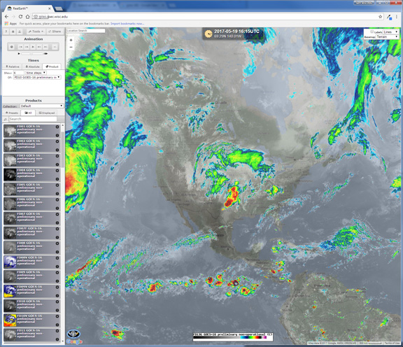
Real-time GOES-16 Data Available in RealEarth: The RealEarth web-mapping platform hosted at the Space Science and Engineering Center (SSEC), is providing visualization access to real-time (preliminary non-operational) GOES-16 Advanced Baseline Imager (ABI) imagery. A majority of the bands, some with enhancements, are available for all sectors (full disk, CONUS, and meso) at full temporal and spatial resolution. These ABI images can be overlaid and combined with over 500 other products in RealEarth, including radar, surface observations, and satellite-derived products (e.g., fire, smoke, flood, cloud properties) from other geostationary and polar orbiting platforms. Due to the large data volume, only the most recent time-steps are kept for any given product based on its coverage and frequency. RealEarth can be accessed through web browsers (https://realearth.ssec.wisc.edu) and mobile apps for iOS and Android devices: Just search the app store for "RealEarth." A dedicated website for just the RealEarth GOES products is now live at https://goes.ssec.wisc.edu. A "GOES App" will be released in the iOS store in the coming weeks.
 (Click image to enlarge)
Figure caption: Screenshot of the dedicated GOES-RealEarth webmap (https://goes.ssec.wisc.edu).
VISITORS:
NEXT WEEK:
LOOKING AHEAD:
| Archived Weeklies Page | Submit a report item |