[ Archive ]
| CIMSS-NOAA Weekly Report [ Archive ] |
ASPB AND CIMSS WEEKLY HIGHLIGHTS FOR THE WEEK ENDING JULY 28, 2017
IN THE PRESS:
ITEMS FOR THE ADMINISTRATOR:
ITEMS FOR THE ASSISTANT ADMINISTRATOR:
ITEMS FOR THE OFFICE DIRECTOR, STAR:
Book Chapter on GOES now available: A book chapter entitled "GOES (Geostationary Operational Environmental Satellite): Past, Present, and Future" is now available. The publisher is Elsevier Inc. The authors are: S.J. Goodman, T.J. Schmit, J. Daniels, W. Denig, and K. Metcalf. More information can be found at http://www.sciencedirect.com/science/article/pii/B978012409548910315X. (T. Schmit, E/RA2, 608-263-0291)
 (Click image to enlarge)
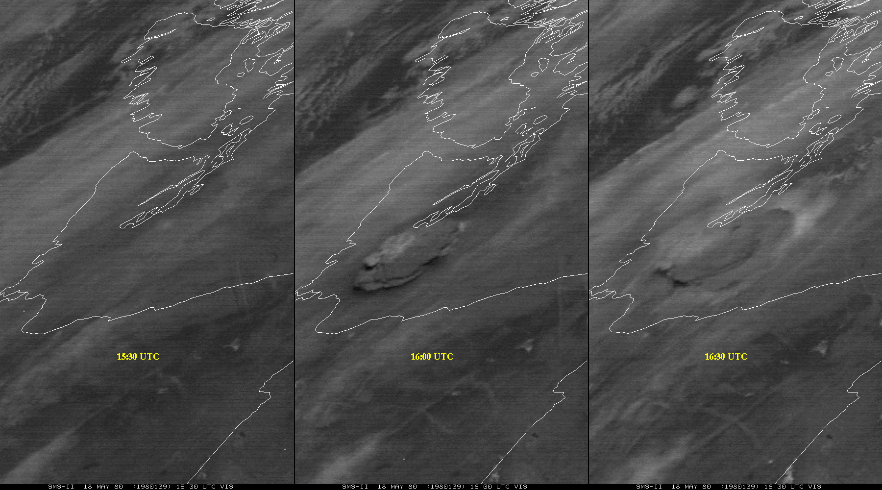
Figure caption: Synchronous Meteorological Satellite (SMS)-2 visible image from May 18, 1980. The left panel is a before image, while the middle and right panel is after the Mt. St. Helen’s eruption in Washington State (note the large ash plume).The data was from the SSEC Data Center. This figure is in the book chapter.
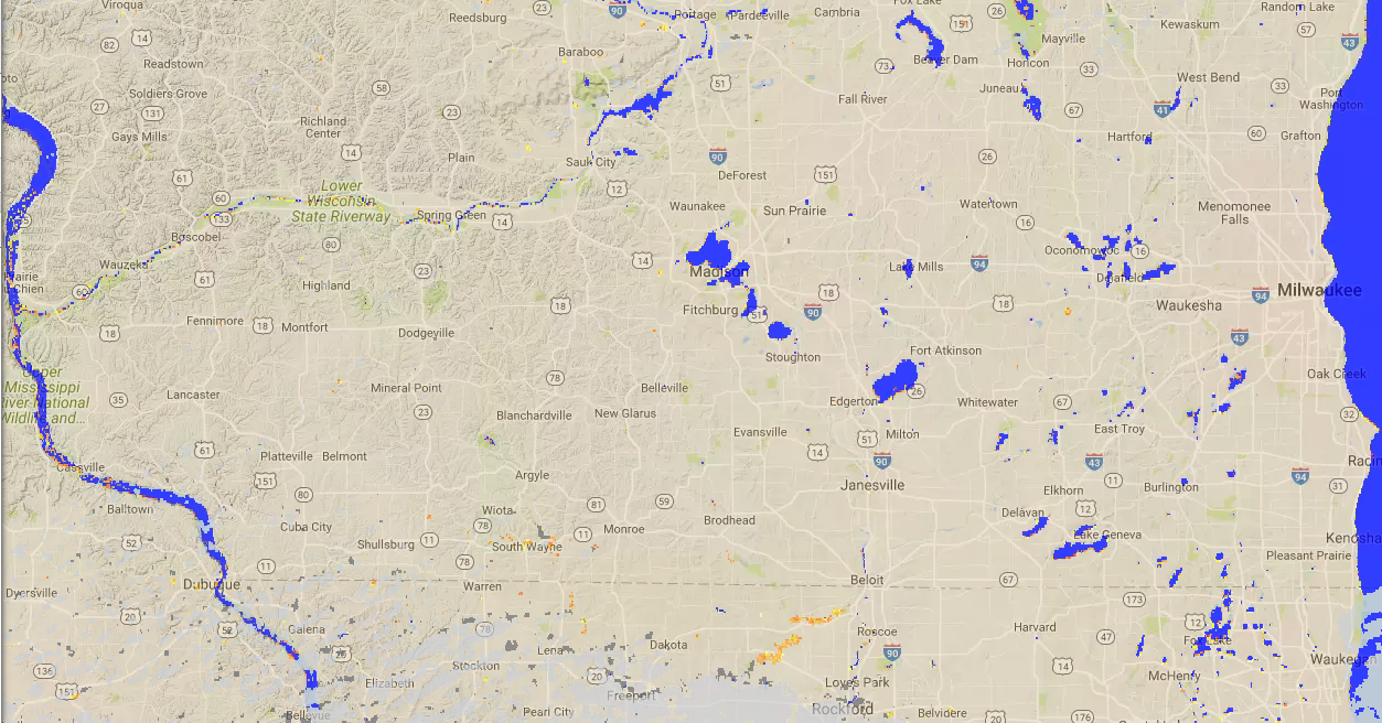
VIIRS Flood Product to FEMA: Using Visible Infrared Imaging Radiometer Suite (VIIRS) Direct Broadcast imagery a flood detection product developed by George Mason University (GMU) is processed at the Cooperative Institute for Meteorological Satellite Studies (CIMSS). In response to recent flooding in Southern Wisconsin and Northern Illinois, CIMSS began distributing this product to the Federal Emergency Management Agency (FEMA) this week. In addition to FEMA, several NOAA River Forecast Center offices access this product that via an Advanced Weather Interactive Processing System (AWIPS) terminal, and the product is publically available online via RealEarth (http://realearth.ssec.wisc.edu). (J. Hoffman, CIMSS, 608-780-1690, D. Santek, CIMSS, 608-263-7410)
 (Click image to enlarge)
Figure caption: A screen capture of 27 July, 2017 VIIRS Flood Product from RealEarth, showing regions of flooding detected in Southern Wisconsin and Northern Illinois.
ITEMS FOR THE DIVISION CHIEF, CoRP:
CIMSS at IGARSS Meeting in Fort Worth TX: Scott Lindstrom (CIMSS) Presented the talk "Latest Assessment of GOES-R (16) Advanced Baseline Imager (ABI) Data Quality from an Application and Training Perspective" at the 2017 IEEE International Geoscience and Remote Sensing Symposium (IGARSS) in Fort Worth Texas. The session in which the paper was presented was "New GEO/LEO Mission Advanced Imagery Products: Optical Sensor Calibration and Applications I"; the session included talks on both the ABI and on the Geostationary Lightning Mapper (GLM). (S. Lindstrom, CIMSS, 608-263-4425)
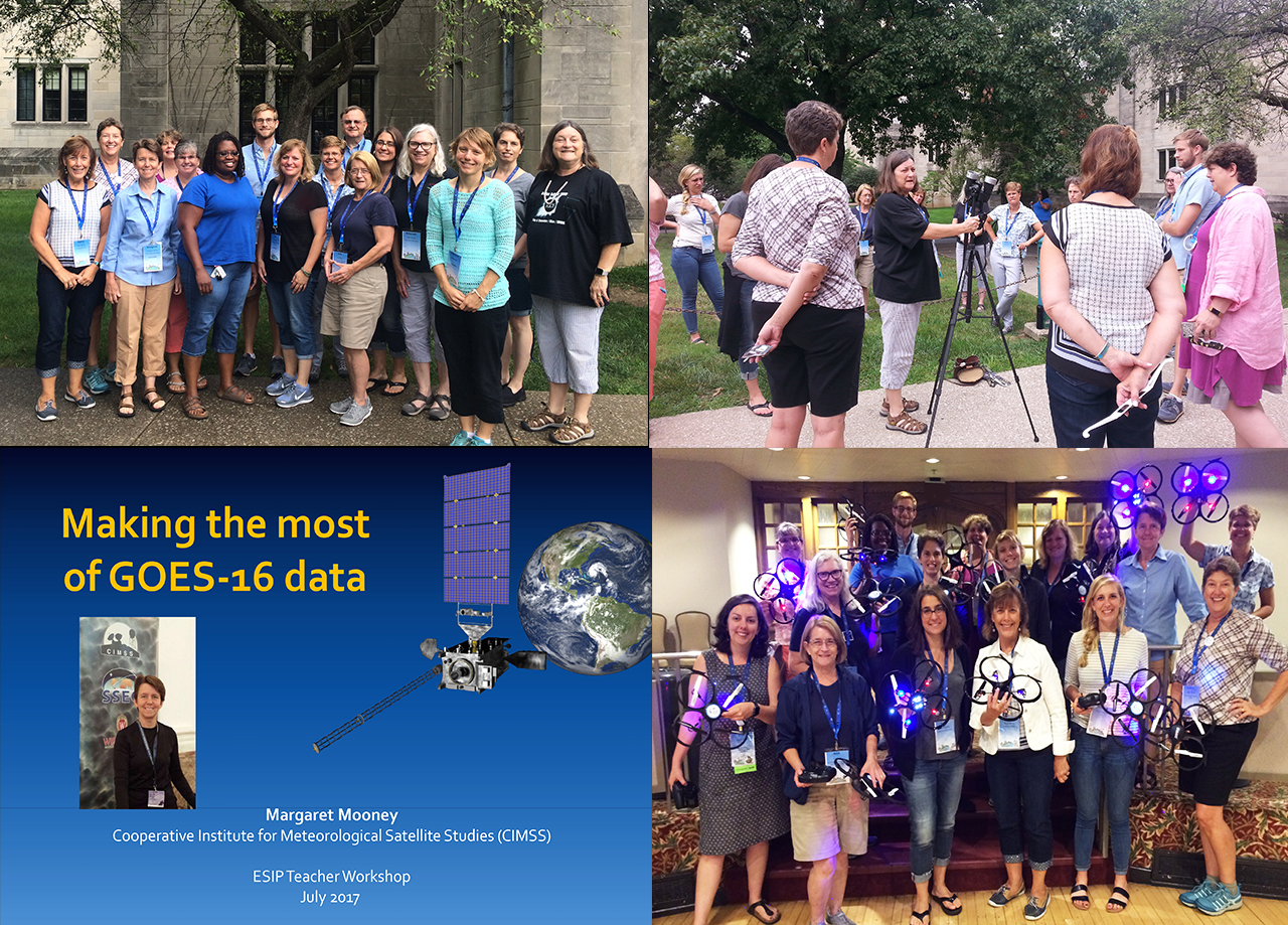
NOAA Data in the Classroom and GOES-16 Featured at Teacher Workshop: Margaret Mooney from the Cooperative Institute for Meteorological Satellite Studies (CIMSS) co-organized and presented a teacher workshop at the ESIP (Earth Science Information Partners) summer meeting in Bloomington Indiana on July 27th. The workshop was entitled "Drones, Data and The Great American Eclipse". Data topics included NOAA's Data in the Classroom activities and GOES-16 resources from the CIMSS GOES-R Education Proving Ground. (M. Mooney, CIMSS, 608-265-2123)
 (Click image to enlarge)
Critical Design Review for GOES-R Fog/Low Stratus Products: A Critical design Review (CDR) for the GOES-R version of the enterprise Fog/Low Stratus (FLS) products was held on July 25, 2017. No significant issues were identified during the review. Analogous FLS products, derived from GOES-NOP data, are routinely utilized to help manage air traffic, resulting in significant cost savings. The GOES-R version of the FLS products is expected to further enhance operational FLS monitoring and forecasting capabilities. (M. Pavolonis, E/RA2, 608-263-9597, Mike.Pavolonis@noaa.gov)
Enhanced Version of ProbSevere Evaluated at Hazardous Weather Testbed: National Weather Service (NWS) forecasters evaluated an enhanced version of the Probability of Severe (ProbSevere) model in the 2017 Hazardous Weather Testbed (HWT). ProbSevere, which was developed by NOAA/NESDIS/STAR in collaboration with the Cooperative Institute for Meteorological Satellite Studies (CIMSS), is a multi-sensor statistical model that determines the probability that a given developing thunderstorm will produce severe weather up to 60 minutes in the future. The enhanced version of ProbSevere includes probabilistic guidance on specific severe weather hazards (wind, hail, and tornado). Forecasters in the HWT provided valuable feedback, which will be used to improve ProbSevere. Most of the forecaster feedback, documented on the Satellite Proving Ground HWT blog (http://goesrhwt.blogspot.com/), was positive, with forecasters noting that the enhanced version of ProbSevere adds value to severe weather warning operations, which is a core component of NOAA’s mission. (M. Pavolonis, E/RA2, 608-263-9597, Mike.Pavolonis@noaa.gov, J. Cintineo, CIMSS, J. Sieglaff, CIMSS)
VISITORS:
Visitor from Australian Bureau of Meteorology: Leon Majewski, from the Australian Bureau of Meteorology, visited the Advanced Satellite Products Branch and the Cooperative Institute for Meteorological Satellite Studies (CIMSS) from July 25-28, 2017. His visit was in support of ongoing collaborations related to various satellite products (volcanic clouds, tropical cyclones, fires, and clouds) and processing systems (Community Satellite Processing Package, Geostationary Cloud Algorithm Testbed, and the Volcanic Cloud Analysis Toolkit). The Bureau is leveraging NOAA’s algorithm development efforts to improve their operational services, while helping NOAA validate and improve the products. (M. Pavolonis, E/RA2, 608-263-9597, Mike.Pavolonis@noaa.gov)
Visitors from NWS Meteorological Development Laboratory (MDL): Jung-Sun Im and John Crockett, from the National Weather Service (NWS) Meteorological Development Laboratory (MDL), visited the Advanced Satellite Products Branch and the Cooperative Institute for Meteorological Satellite Studies (CIMSS) July 26-27, 2017. The purpose of their visit was to discuss a pending project to transition the Probability of Severe (ProbSevere) model to National Centers for Environmental Prediction (NCEP) Central Operations (NCO). The ProbSevere transition to NCO is a milestone in the Fiscal Year 2018 (FY18) NWS Annual Operating Plan, pending the results of the FY18 budget process. Dr. Im and Mr. Crockett provided guidance on the NWS research-to-operations process. A successful transition of ProbSevere to NCO will help ensure that NWS forecasters have sustained and reliable access to ProbSevere products, which have been shown to improve severe weather warnings. (M. Pavolonis, E/RA2, 608-263-9597, Mike.Pavolonis@noaa.gov, J. Cintineo, CIMSS, J. Sieglaff, CIMSS)
NEXT WEEK:
LOOKING AHEAD:
| Archived Weeklies Page | Submit a report item |